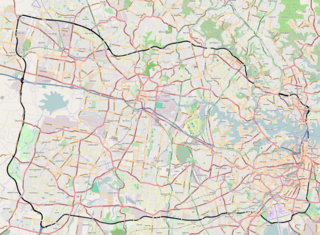
The now cancelled route that the expressway would have taken from Tarban Creek Bridge to Epping Road at East Ryde
The North Western Expressway or Castlereagh Freeway was a planned freeway route in Sydney, New South Wales, Australia, intended to link the Sydney CBD to its north-western suburbs, and ultimately the F3 Freeway to Newcastle.
Australia, officially the Commonwealth of Australia, is a sovereign country comprising the mainland of the Australian continent, the island of Tasmania, and numerous smaller islands. It is the largest country in Oceania and the world's sixth-largest country by total area. The neighbouring countries are Papua New Guinea, Indonesia, and East Timor to the north; the Solomon Islands and Vanuatu to the north-east; and New Zealand to the south-east. The population of 26 million is highly urbanised and heavily concentrated on the eastern seaboard. Australia's capital is Canberra, and its largest city is Sydney. The country's other major metropolitan areas are Melbourne, Brisbane, Perth, and Adelaide.
The M1 Pacific Motorway, also known by the former names F3 Freeway, Sydney–Newcastle Freeway, and Sydney–Newcastle Expressway; is a 127 km (79 mi) stretch of freeway linking Sydney to the Central Coast, Newcastle and Hunter regions of New South Wales. It is part of the AusLink road corridor between Sydney and Brisbane. The name "F3 Freeway", reflects its former route allocation, but is commonly used by both the public and the government to refer to the roadway long after the route allocation itself was no longer in use.
The Newcastle metropolitan area is the second most populated area in the Australian state of New South Wales and includes the Newcastle and Lake Macquarie local government areas. It is the hub of the Greater Newcastle area which includes most parts of the local government areas of City of Newcastle, City of Lake Macquarie, City of Cessnock, City of Maitland and Port Stephens Council.
The route was planned as early as 1962 (even providing a proposed freeway "dotted line" in the UBD street directories of the 1970s), with the section from Fig Tree Bridge to Gladesville Bridge and the Western Distributor being the only completed sections. Work on stage one, from Ultimo to Pyrmont Bridge Road, began in 1974. Twelve people were arrested during protests in Ultimo against the expressway, a green ban was imposed by the Builders Labourers Federation,[1] and the Whitlam government threatened to cut off $42 billion in road funding if the NSW government continued with construction.[2] As a result, construction was suspended.
Universal Publishers produce the ubiquitous UBD-Gregory's street directories in Australia. The names of these publications have come to be used as a generic term for street directories in many Australian cities.
Fig Tree Bridge is a concrete girder bridge that spans the Lane Cove River, 7 km northwest of the central business district of Sydney in New South Wales, Australia. It is immediately to the north of Tarban Creek Bridge. The bridge carries Burns Bay Road and a footpath and connects the suburbs of Hunters Hill and Linley Point.
Gladesville Bridge is an arch bridge near Gladesville that spans the Parramatta River, west of central Sydney, Australia. It links the suburbs of Huntleys Point and Drummoyne. It is a few kilometres upstream of the more famous Sydney Harbour Bridge and is part of Victoria Road. When it was completed in 1964, Gladesville Bridge was the longest single span concrete arch ever constructed. Gladesville Bridge is the largest of a complex of three bridges, including Fig Tree Bridge and Tarban Creek Bridge, designed to carry traffic as part of the North Western Expressway. The bridge was the first phase of this freeway project that was to connect traffic from the Newcastle via Wahroonga/Lane Cove, then through Glebe/Annandale to connect into the city. Due to community action the freeway project was abandoned by the Wran government in 1977, leaving the Gladesville bridge connecting the existing arterial roads.
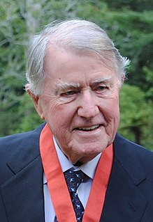
The Wran Government cancelled the project in 1977, as a part of a change in government policy regarding freeways.[3]
Neville Kenneth Wran, was an Australian politician who was the Premier of New South Wales from 1976 to 1986. He was the national president of the Australian Labor Party (ALP) from 1980 to 1986 and chairman of both the Lionel Murphy Foundation and the Commonwealth Scientific and Industrial Research Organisation (CSIRO) from 1986 to 1991.
The Western Distributor is a 3.8-kilometre-long (2.4 mi) grade-separated freeway that is primarily elevated for the majority of its route on the western fringe of the Sydney central business district in New South Wales, Australia. From its northern terminus, it links the southern end of the Bradfield Highway at the Sydney Harbour Bridge to Victoria Road in Rozelle, at its western terminus near White Bay. The freeway is designated as part of the A4 for its entire distance.
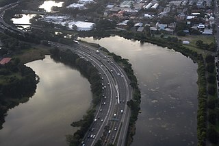
The section of freeway from Gladesville Bridge to Fig Tree Bridge at Hunters Hill was completed in 1965 with the opening of Tarban Creek Bridge.
The Tarban Creek Bridge, a prestressed concrete arch bridge that spans the Tarban Creek, is located west of the Sydney central business district in New South Wales, Australia. The bridge is situated between the Gladesville Bridge and the Fig Tree Bridge, being immediately to the north of Gladesville Bridge. The bridge carries the Burns Bay Road and a footpath and connects the suburbs of Hunters Hill and Huntleys Point.
The route from there to approximately the intersection of Delhi Road and Epping Road was shown on a 1984 Department of Main Roads map, but was removed by 1988 when that map was reprinted.
Epping Road is a 10-kilometre-long (6.2 mi) arterial road located on the Lower North Shore and Northern Suburbs in Sydney, New South Wales, Australia. Epping Road is a major route linking the lower north shore and Sydney central business district to the north western suburbs and Hills District of metropolitan Sydney, being a major access road to the commercial, industrial and university areas of North Ryde and Macquarie Park.
The Westlink M7 continues along the original route from the M2 to Dean Park, where the M7 turns south while the North West Freeway corridor continues west.
The unused but still reserved corridor passes north of suburbs including Shalvey and Willmot, continuing west past Llandilo to stop abruptly near Londonderry at the foot of the Blue Mountains.
The North Shore refers to a group of suburbs north of Sydney Central Business District in New South Wales, Australia. The term generally refers to the suburbs located on the northern side of Sydney Harbour up to and including Hornsby and between Middle Harbour and the Lane Cove River.
The Lane Cove River, a northern tributary of the Parramatta River, is a tide-dominated, drowned valley estuary west of Sydney Harbour, located in Sydney, New South Wales, Australia. The river is a tributary of the Parramatta River, winding through a bushland valley. It joins Parramatta River at Greenwich and Woolwich, where together they form an arm of Sydney Harbour.
Wynyard railway station is a heritage-listed underground commuter rail station located in the north-west precinct of the Sydney central business district, in New South Wales, Australia. The station opened on 28 February 1932 to coincide with the opening of the Sydney Harbour Bridge.
The M2 is a route in Sydney, New South Wales, Australia. It links Artarmon to Bella Vista. It consists of two separately named motorways, the M2 Hills Motorway and the Lane Cove Tunnel. The M2 route replaces the motorway sections of what was known as Metroad 2 from 1993 to 2013, with the non-motorway sections replaced by the A2 route.
The Sydney Orbital Network is a 110 kilometre motorway standard ring road or orbital around the city of Sydney, the capital of New South Wales in Australia. It runs north from Sydney Airport, underneath the CBD to the North Shore, west to the Hills District, south to Prestons and then east to connect with the airport. Much of the road is privately owned and financed by tolls.
The Warringah Freeway is a 3-kilometre (1.9 mi) divided freeway located in Sydney, New South Wales, Australia. The freeway forms part of the M1, the Sydney Orbital Network, and the Highway 1 network. The primary function of the freeway is to provide an alternative high-grade route from the Sydney Harbour Tunnel and the Bradfield Highway at Milsons Point to the A8 and the Gore Hill Freeway. The freeway reduces traffic demands on the Pacific Highway throughout Sydney's lower north shore, bypassing North Sydney and Crows Nest. Completed in a series of stages between June 1968 and August 1992, the Warringah Freeway provides a vital link to access most of the suburbs in Sydney and is also a major route to the north, south, east and west of the central business district.
The Hills Motorway is a tollway in north-western Sydney, Australia, owned by toll road operator Transurban. It forms part of Sydney's M2 route and the 110 km Sydney Orbital Network. West of Pennant Hills Road, the M2 is also part of the National Highway.
The M4 Western Motorway is a 51.5-kilometre-long (32.0 mi) dual carriageway motorway in western Sydney, New South Wales, Australia. The partially-tolled motorway stretches from Haberfield in the east, to Glenbrook in west, where it continues as the Great Western Highway as the A32.
The Southern Cross Drive is a 4.8 km (3 mi) dual carriage untolled motorway in Sydney, New South Wales, Australia. Part of the M1 and Sydney Orbital Network, the road, a freeway that opened in 1969, links the Eastern Distributor and South Dowling Street at Kensington in the north to General Holmes Drive at Sydney Airport in the south.
Sydney Bypass refers to a number of roads, existing and proposed, that motorists can use to avoid the congested approaches to the city's central business district (CBD). The main bypasses are:
The Northern Suburbs is the metropolitan area on the northern bank of the Parramatta River in Sydney, New South Wales, Australia beginning with suburbs in line with or east of West Pennant Hills and ending with suburbs west of the Lane Cove National Park, south of Hornsby. This area includes suburbs in the local government areas of Hornsby Shire, City of Ryde, the Municipality of Hunter's Hill, and parts of the City of Parramatta.
This is a list of freeways in Australia, sorted by states and territories and their corresponding routes. This list includes tollways / toll roads such as the CityLink freeway system in Melbourne. This list has over 70 entries. The only jurisdiction in Australia without freeways is the Northern Territory. Victoria has the largest and densest freeway network in Australia.
The Lane Cove Valley Expressway was a planned freeway route in Sydney, New South Wales, Australia, intended to link the Sydney CBD to its north-western suburbs, and ultimately to the Pacific Motorway and Newcastle.
NorthConnex is a 9-kilometre (5.6 mi) motorway tunnel under construction in northern Sydney, New South Wales, Australia. When completed in 2020, it will connect the M1 Pacific Motorway to the M2 Hills Motorway. It was previously known as the F3 to M2 link, then the M1 to M2 link after alpha numeric route numbers began to be used in New South Wales. The road has also colloquially been referred to as the "missing link", because its construction will complete the combination of the Sydney Orbital Network and its north-south motorway links to the National Highway.
Longueville Motor Bus Company was an Australian bus company operating route bus services on Sydney's Lower North Shore.
This page is based on this Wikipedia article Text is available under the CC BY-SA 4.0 license; additional terms may apply. Images, videos and audio are available under their respective licenses.