
The Georges River, also known as Tucoerah River, is an intermediate tide-dominated drowned valley estuary, that is located in Sydney in the state of New South Wales, Australia. The Georges River is located south and south-west from the Sydney CBD, with the mouth of the river being at Botany Bay.

Penrith is a city in New South Wales, Australia, located in Greater Western Sydney, 55 kilometres (31 mi) west of the Sydney central business district on the banks of the Nepean River, on the outskirts of the Cumberland Plain. Its elevation is 32 metres (105 ft).

The Royal Alexandra Interprovincial Bridge, also known as the Alexandra Bridge or Interprovincial Bridge, is a steel truss cantilever bridge spanning the Ottawa River between Ottawa, Ontario and Gatineau, Quebec. In addition to carrying vehicle traffic, a shared use pathway on the bridge for pedestrians and cyclists is maintained by the National Capital Commission.

Great Western Highway is a 202-kilometre-long (126 mi) state highway in New South Wales, Australia. From east to west, the highway links Sydney with Bathurst, on the state's Central Tablelands.

The Hawkesbury River, or Hawkesbury-Nepean River a river located northwest of Sydney, New South Wales, Australia. The Hawkesbury River and its associated main tributary, the Nepean River, almost encircle the metropolitan region of Sydney. Between Wisemans Ferry and the Pacific Ocean marks the boundary of Greater Metropolitan Sydney in the south and the Central Coast region to the north.

The Nepean River, is a major perennial river, located in the south-west and west of Sydney, New South Wales, Australia. The Nepean River, and, continuing by its downstream name, the Hawkesbury River, almost encircles the metropolitan region of Sydney.
Victoria Bridge may be a reference to:

Emu Plains is a suburb of Sydney in the state of New South Wales, Australia. It is 58 kilometres west of the Sydney central business district, in the local government area of the City of Penrith and is part of the Greater Western Sydney region.
The Division of Nepean was an Australian Electoral Division in the state of New South Wales. It was located in the western suburbs of Sydney. It originally covered the suburbs of Granville, Lithgow and Penrith. After the redistribution of 27 February 1913 it also included the suburb of Homebush.

Wallacia is a suburb of Sydney, in the state of New South Wales, Australia. Formerly a rural village it is 68 kilometres (42 mi) west of the Sydney GPO, in the local government areas of the City of Penrith, City of Liverpool and Wollondilly Shire. It is part of the Greater Western Sydney region.

The City of Penrith is a local government area in the state of New South Wales, Australia. The seat of the city is located in Penrith, located within Sydney about 50 kilometres (31 mi) west of Sydney central business district. It occupies part of the traditional lands of the Darug people. First incorporated as a municipality on 12 May 1871, on 1 January 1949, the municipalities of Penrith, St Marys and Castlereagh and part of the Nepean Shire amalgamated to form a new Municipality of Penrith. Penrith was declared a City on 21 October 1959, and expanded westwards to include Emu Plains and Emu Heights, formerly part of the City of Blue Mountains, on 25 October 1963. As of the 2021 census the City of Penrith had an estimated population of 217,664.

Emu Plains railway station is a heritage-listed railway station located on the Main Western line in the western Sydney suburb of Emu Plains in the City of Penrith local government area of New South Wales, Australia. It was designed by the New South Wales Government Railways and built from 1884 to 1907 by M. Reed, et al. It is also known as Emu Plains Railway Station group. The property was added to the New South Wales State Heritage Register on 2 April 1999. The station is served by Sydney Trains T1 Western line services and NSW TrainLink Blue Mountains line services.

The Victoria Bridge, also known as the Victoria Bridge over the Nepean River, is a heritage-listed former railway bridge and now wrought iron box plate girder road bridge across the Nepean River on the Great Western Highway in the western Sydney suburb of Penrith in the City of Penrith local government area of New South Wales, Australia. The bridge was designed by John Whitton, the Engineer–in–Chief of New South Wales Government Railways, and built from 1862 to 1867 by William Piper, Peto Brassey and Betts (superstructure), William Watkins (piers). It is also known as Victoria Bridge, The Nepean Bridge and RTA Bridge No. 333. It was added to the New South Wales State Heritage Register on 27 May 2016.
The Nepean Creative and Performing Arts High School is a government-funded co-educational comprehensive and specialist secondary day school with speciality in performing arts, located in Emu Plains, a suburb in western Sydney, New South Wales, Australia. The school is located adjacent to the Emu Plains railway station.

Maldon is a locality in the Macarthur Region of New South Wales, Australia, in the Wollondilly Shire. In the 2016 census it had a population of 15.

The Nepean River railway bridge is a heritage-listed railway bridge that carries the Main Southern railway line across Menangle Road and the Nepean River located at the outer south-western Sydney settlement of Menangle in the Wollondilly Shire local government area of New South Wales, Australia. It was designed by John Whitton as the Engineer-in-Chief, of the New South Wales Government Railways and NSW Department of Public Works. The railway bridge was built in 1863 by Messers Peto, Brassey and Betts. It is also known as Menangle rail bridge over Nepean River and Menangle Railway Bridge. The property was added to the New South Wales State Heritage Register on 2 April 1999.
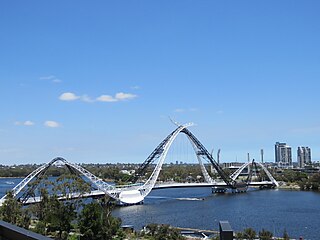
Matagarup Bridge is a suspension pedestrian bridge crossing over the Swan River in Perth, Western Australia. Situated approximately half-way between Heirisson Island and the Goongoongup Bridge, it provides pedestrian access between Burswood and East Perth. The bridge connects visitors to the Burswood Peninsula, including the Perth Stadium, with public transport and car parks in East Perth and the Perth central business district.

Nepean Football Association (NFA) is the governing body of amateur football across the Penrith, Hawkesbury and Blue Mountains areas of western Sydney. Clubs are located in four council areas, City of Penrith, City of Blue Mountains, City of Hawkesbury and Wollondilly Shire. Its administrative offices are located in Penrith.

Emu Plains Underbridge is a heritage-listed steel truss railway underbridge located off Bruce Neale Dr approximately 1.3 kilometres (0.81 mi) west of the Penrith railway station in the western Sydney suburb of Penrith in the City of Penrith local government area of New South Wales, Australia. It was designed by James Fraser, the existing lines branch and the New South Wales Government Railways. It was built in 1907, with fabrication by R. Tulloch & Co.; and erection by day labour. It is also known as Emu Plains Underbridge and Penrith Underbridge. The property is owned by Transport Asset Holding Entity, an agency of the Government of New South Wales. It was added to the New South Wales State Heritage Register on 28 June 2013.

