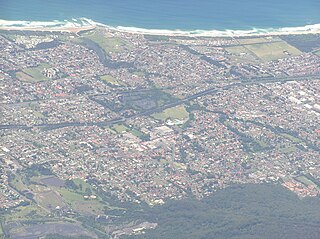
Wollongong, colloquially referred to as The Gong, is a city located in the Illawarra region of New South Wales, Australia. The name is believed to originate from the Dharawal language, meaning either 'five islands/clouds', 'ground near water' or 'sound of the sea'. Wollongong lies on the narrow coastal strip between the Illawarra Escarpment and the Pacific Ocean, 85 kilometres south of central Sydney. Wollongong had an estimated urban population of 302,739 at June 2018, making it the third-largest city in New South Wales after Sydney and Newcastle and the tenth-largest city in Australia by population. The city's current Lord Mayor is Gordon Bradbery AM who was elected in 2021.

Fairy Meadow is a suburb in the City of Wollongong, New South Wales, Australia. Located in the Illawarra region and only 4 km from the city centre, it is a mainly low-density residential area, with a large strip of commercial and industrial properties along and off the Princes Highway.

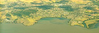
Lake Illawarra is an open and trained intermediate wave dominated barrier estuary or large coastal lagoon, is located in the Illawarra region of New South Wales, situated about 100 kilometres (62 mi) south of Sydney, Australia.
Dapto is a suburb of Wollongong in the Illawarra region of New South Wales, Australia, located on the western side of Lake Illawarra and covering 7.15 square kilometres (2.76 sq mi). As at the 2021 census, the suburb had a population of 10,954.

The Illawarra is a coastal region in the southeast of the Australian state of New South Wales. It is situated immediately south of Sydney and north of the South Coast region. It encompasses the two cities of Wollongong, Shellharbour and the coastal town of Kiama. Wollongong is the largest city of the Illawarra with a population of 240,000, then Shellharbour with a population of 70,000 and Kiama with a population of 10,000. These three cities have their own suburbs. Wollongong stretches from Otford in the north to Windang in the south, with Maddens Plains and Cordeaux in the west.
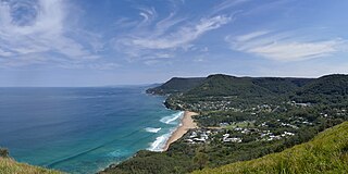
Stanwell Park is a coastal village and northern suburb of Wollongong, New South Wales, Australia. It is the northernmost point of the Illawarra coastal strip and lies south of Sydney's Royal National Park. It is situated in a small valley between Bald Hill to the north, Stanwell Tops to the west and Mount Mitchell to the south. It has two lagoons from the village's two creeks, Stanwell and Hargrave Creeks and a beach running between headlands. Stanwell Park and the surrounding suburbs are colloquially referred to by its postcode 2508.

Gerringong is a town located about ten minutes drive south of Kiama, and about twenty minutes north of Nowra in the Illawarra region of New South Wales, Australia in the Municipality of Kiama. At the 2016 census, Gerringong had a population of 3,966. One theory says that the name derives from an Aboriginal word meaning "fearful place".

Princes Motorway is a 62-kilometre (39 mi) predominantly dual carriage untolled motorway that links Sydney to Wollongong and further south through the Illawarra region to Oak Flats. Part of the Australian Highway 1 network, the motorway is designated route M1.
Albion Park is a suburb situated in the Macquarie Valley in the City of Shellharbour, which is in turn one of the three local government areas that comprise the Wollongong Metropolitan Area, New South Wales, Australia. Although it is surrounded by a 'green belt' of farms, Albion Park had a population of 13,316 at the 2016 census.

Windang is a suburb of Wollongong in New South Wales on the southern tip of the peninsula guarding the ocean entrance to Lake Illawarra. Windang is popular for its fishing, prawning, boating, windsurfing and yachting. Windang is about 98 km south of Sydney, approximately 20 minutes drive south of the Wollongong CBD and about seven minutes from Shellharbour.

Albion Park railway station is a heritage-listed railway station located on the South Coast railway line on the Princes Highway in Albion Park Rail, New South Wales, Australia. The station was designed by New South Wales Government Railways and built during 1887 by William Monie & Company, with the single line railway line built by David Proudfoot and Thomas Logan. The complex is also known as the Albion Park Railway Station Group. The property was added to the New South Wales State Heritage Register on 2 April 1999. The station is located close to Shellharbour Airport.

Woonona is a suburb north of Wollongong, New South Wales, Australia, south of Sydney. It is served by Woonona Station on the South Coast Line, and by the Princes Highway.

The City of Shellharbour is a local government area in the Illawarra region of New South Wales, Australia. The city is located about 100 kilometres (62 mi) south of Sydney and covers the southern suburbs of the Wollongong urban area centred on Shellharbour and it had an estimated population of 68,460 at the 2016 census.

Oak Flats is a suburb of Shellharbour, New South Wales, Australia situated on the south western shores of Lake Illawarra and within the Illawarra region of New South Wales. It is a residential area, which had a population of 6,415 at the 2016 census.

Warrawong is a suburb of Wollongong in the Illawarra region of New South Wales, Australia. It is situated on the northeast corner of Lake Illawarra.
Corrimal is a suburb north of the city of Wollongong, New South Wales, Australia. Corrimal's CBD is situated on the Princes Highway, and several streets adjacent to it. The main shopping centres are Lederer Corrimal and Corrimal Park Mall next to the park on the main thoroughfare of Corrimal itself. Outside this centre is an old locomotive that is affectionately known as "The Green Frog". Corrimal's welcome signs feature The Green Frog, as it ran on the Bulli Colliery Line to Bellambi Haven from 1909 to 1967. To the west is a lawn bowls club and a wealthy foothill neighbourhood of residences bordering bushland.

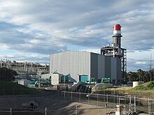
Tallawarra Power Station is a 435-megawatt (583,000 hp) combined cycle natural gas power station in the city of Wollongong, New South Wales, Australia. Owned and operated by EnergyAustralia, the station is the first of its type in New South Wales and produces electricity for the state during periods of high demand. It is located on the western shore of Lake Illawarra in the suburb of Yallah.

Marshall Mount is a suburb of Wollongong in New South Wales, Australia. It is located between the larger centres of Dapto and Albion Park.
Koonawarra is a suburb of Wollongong, New South Wales, Australia. It is located on the western shore of Lake Illawarra. Koonawarra, or Exmouth, as it was then called, was one of the first five land grants located in the Illawarra. It was a grant of 1300 acres made to Richard Brooks in 1817. The grant faced Lake Illawarra and extended from Brook's Creek to Mullet Creek. Koonawarra was the aboriginal name for the area. "Exmouth" was later secured by Henry Osborne and became part of his central Illawarra estate, extending from Macquarie Rivulet to Mullet Creek, and from Lake Illawarra to the mountains. The name Koonawarra is from the aboriginal word "Koonawarra” meaning "swan”

Wongawilli is a southern suburb of Wollongong, Australia at the foot hills of the Illawarra escarpment. The word 'Wonga' is a native Aboriginal word meaning native pigeon.