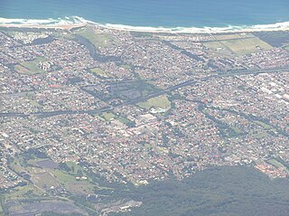
Wollongong is a city located in the Illawarra region of New South Wales, Australia. The name is believed to originate from the Dharawal language, meaning either 'five islands/clouds', 'ground near water' or 'sound of the sea'. Wollongong lies on the narrow coastal strip between the Illawarra Escarpment and the Pacific Ocean, 85 kilometres south of central Sydney. Wollongong had an estimated urban population of 302,739 at June 2018, making it the third-largest city in New South Wales after Sydney and Newcastle and the tenth-largest city in Australia by population. The city's current Lord Mayor is Gordon Bradbery AM who was elected in 2021.
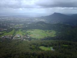
Mount Kembla is a suburb and a mountain in the Illawarra region of New South Wales, Australia.

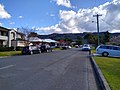
Balgownie is a small suburb of Wollongong, New South Wales, Australia.
Mount Pleasant is a hilly suburb in the city of Wollongong, New South Wales, Australia. It is situated on the northern flank of Mount Keira extending across to the Illawarra escarpment and is exclusively residential. It is home to the Rhododendron Park, found on Parrish Avenue. Mount Pleasant has a small local primary school Pleasant Heights Public School which has approximately 180 enrolled students. The suburb is locally notable for its commonly known Brokers Road which is amongst the steepest roads in New South Wales.

Coalcliff is a town on the coast of New South Wales, Australia, between Sydney and Wollongong.

Clifton is a village on the coast of New South Wales, Australia, between Sydney and Wollongong. Along with nearby Coalcliff, the village began life as a coal-mining centre. It is situated on a narrow area between the sea and the Illawarra escarpment. The electrified South Coast railway line passes through, but the station at Clifton was closed in 1915. It reopened on 4 July 1934 and closed for the last time on 27 November 1983, at the time of double tracking and electrification.

Austinmer is a northern village of Wollongong on the south coast of New South Wales, Australia. It sits in the northern Illawarra region, south of Stanwell Park and immediately north of Thirroul.

Scarborough is a small northern seaside suburb of Wollongong on the south coast of New South Wales, Australia. It sits in the northern Illawarra region on a narrow stretch between the Illawarra escarpment and sea cliffs.
Corrimal is a suburb north of the city of Wollongong, New South Wales, Australia. Corrimal's CBD is situated on the Princes Highway, and several streets adjacent to it. The main shopping centres are Lederer Corrimal and Corrimal Park Mall next to the park on the main thoroughfare of Corrimal itself. Outside this centre is an old locomotive that is affectionately known as "The Green Frog". Corrimal's welcome signs feature The Green Frog, as it ran on the Bulli Colliery Line to Bellambi Haven from 1909 to 1967. To the west is a lawn bowls club and a wealthy foothill neighbourhood of residences bordering bushland.

Bellambi is a suburb of Wollongong in the Illawarra region of New South Wales, Australia. It has a railway station on the NSW TrainLink South Coast Line.

Abernethy is a small town in the City of Cessnock, in the Hunter Region in the state of New South Wales, Australia. Abernethy is located 8 kilometres south-east of the town of Cessnock, NSW and is adjacent to Werakata National Park and the Aberdare State Forest. The town was founded near a coal mine and some of the historic buildings remain. In 2016 348 lived there with the median age being 32 and 74.8% being born in Australia.
Kembla Heights is a village west of Wollongong, New South Wales in the Parish of Kembla County of Camden. It is situated along Harry Graham Drive and upper Cordeaux Road and is part of a tourist route that runs along the Illawarra escarpment for a distance between Mount Kembla and Mount Keira. The Dendrobium Colliery is located in Kembla Heights.
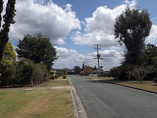
Ebbw Vale is a suburb of Ipswich in the City of Ipswich, Queensland, Australia. Ebbw Vale is a Welsh name, so the ‘w’ is pronounced with an ‘oo’ sound. In the 2021 census, Ebbw Vale had a population of 540 people.
Pelaw Main is a hamlet a few kilometres south-west of Kurri Kurri, in the Hunter Region of New South Wales, Australia. It owes its origins entirely to the colliery there of the same name. It had a population of 1,027 in 2011

Primbee is a small suburb of Wollongong, New South Wales, Australia. It is located on the northern end of the Windang Peninsula separating Lake Illawarra and the Pacific Ocean. Primbee is close to Windang and Warrawong in the Illawarra. It was originally referred to as “The Lake Suburb” until formally being named as Primbee. It is sometimes referred to as "The Upper Peninsula" or "The Upper Island". The latter refers to a local legend that there was once a second entrance to Lake Illawarra located between Primbee and Kemblawarra Industrial Park.

The Cordeaux River, a perennial river of the Hawkesbury-Nepean catchment, is located in the Southern Highlands and Macarthur regions of New South Wales, Australia.
Berkeley is a suburb of Wollongong, New South Wales. The suburb is located in Wollongong's southern suburbs, on the northern shore of Lake Illawarra, and is one of the city's most populous suburbs. At the 2021 census, it had a population of 7,798.

Wongawilli is a southern suburb of Wollongong, Australia at the foot hills of the Illawarra escarpment. The word "Wonga" is a native Aboriginal word meaning native pigeon.
Huntley is a suburb of the City of Wollongong to the west of Dapto. At the 2021 census, it had a population of 66.
Kembla Grange is a suburb west of Berkeley, in the City of Wollongong. At the 2021 census, it had a population of 1,452.