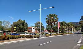
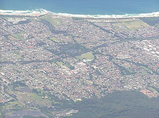
Wollongong is a city located in the Illawarra region of New South Wales, Australia. The name is believed to originate from the Dharawal language, meaning either 'five islands/clouds', 'ground near water' or 'sound of the sea'. Wollongong lies on the narrow coastal strip between the Illawarra Escarpment and the Pacific Ocean, 85 kilometres south of central Sydney. Wollongong had an estimated urban population of 302,739 at June 2018, making it the third-largest city in New South Wales after Sydney and Newcastle and the tenth-largest city in Australia by population. The city's current Lord Mayor is Gordon Bradbery AM who was elected in 2021.

Fairy Meadow is a suburb in the City of Wollongong, New South Wales, Australia. Located in the Illawarra region and only 4 km from the city centre, it is a mainly low-density residential area, with a large strip of commercial and industrial properties along and off the Princes Highway.
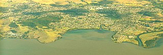
Dapto is a suburb of Wollongong in the Illawarra region of New South Wales, Australia, located on the western side of Lake Illawarra and covering 7.15 square kilometres (2.76 sq mi). As at the 2021 census, the suburb had a population of 10,954.

Mount Keira is a suburb and mountain in the Illawarra region of New South Wales, Australia.

Princes Motorway is a 62-kilometre (39 mi) predominantly dual carriage untolled motorway that links Sydney to Wollongong and further south through the Illawarra region to Oak Flats. Part of the Australian Highway 1 network, the motorway is designated route M1.

Balgownie is a small suburb of Wollongong, New South Wales, Australia.
Mount Pleasant is a hilly suburb in the city of Wollongong, New South Wales, Australia. It is situated on the northern flank of Mount Keira extending across to the Illawarra escarpment and is exclusively residential. It is home to the Rhododendron Park, found on Parrish Avenue. Mount Pleasant has a small local primary school Pleasant Heights Public School which has approximately 180 enrolled students. The suburb is locally notable for its commonly known Brokers Road which is amongst the steepest roads in New South Wales.

The Illawarra escarpment, or officially the Illawarra Range, is the fold-created cliffs and plateau-eroded outcrop mountain range west of the Illawarra coastal plain south of Sydney, in the state of New South Wales, Australia. The range encloses the Illawarra region which stretches from Stanwell Park in the north to Kiama, Gerringong and the Shoalhaven River in the south.
Keira is an electoral district of the Legislative Assembly in the Australian state of New South Wales. It is currently represented by Ryan Park of the Labor Party.

North Wollongong is a coastal suburb of the City of Wollongong, New South Wales, Australia. It is immediately to the north of the Wollongong city centre. Although North Wollongong is an official suburb with precise boundaries, the term North Wollongong may refer to northern areas of Wollongong which are not part of the suburb.

Keiraville is an inner suburb of the city of Wollongong, New South Wales, Australia in the Illawarra region. It is situated in the foothills of Mount Keira, approximately three kilometres northwest of Wollongong.
Cordeaux Heights is a suburb in the city of Wollongong, New South Wales, Australia. It is situated on the eastern foothills of Mount Kembla as is its southern neighbour Farmborough Heights. Its northern boundary of housing is along Cordeaux Road which goes to Mount Kembla Village. Cordeaux Heights has several shops, including a cafe, supermarket/takeaway, bottle shop, hairdresser, dentist and pizzeria.

Figtree is an inner western suburb of Wollongong, New South Wales, Australia. It is south-west of West Wollongong and connected to Wollongong by the Princes Highway
West Wollongong is the innermost western suburb of the coastal city of Wollongong, New South Wales, Australia. It is mainly a residential area, serviced by a small commercial strip with a music store, chicken shop, electric goods store and carpet store along the Princes Highway with several petrol stations, two restaurants, a liquor store, a chemist and a flower shop.
Elonera Montessori School is located in Wollongong, New South Wales, and was established in 1987 by parents and friends of an alternative school who wished to offer a Montessori education.

Marshall Mount is a suburb of Wollongong in New South Wales, Australia. It is located between the larger centres of Dapto and Albion Park.
Berkeley is a suburb of Wollongong, New South Wales. The suburb is located in Wollongong's southern suburbs, on the northern shore of Lake Illawarra, and is one of the city's most populous suburbs. At the 2021 census, it had a population of 7,798.
East Corrimal is a northern seaside suburb of Wollongong, New South Wales, Australia. Predominantly residential, the suburb includes Corrimal High School and Corrimal East Public School, as well as Corrimal Beach and Corrimal Beach Tourist Park at the eastern end. A public park was opened in 1959 to the west of the high school and north of the primary school, named Phil Adams Park, which features tall trees, paths and several seats.
Ouseley or Ousley is a surname. Notable people with the surname include: