
Wollongong is a city located in the Illawarra region of New South Wales, Australia. The name is believed to originate from the Dharawal language, meaning either 'five islands/clouds', 'ground near water' or 'sound of the sea'. Wollongong lies on the narrow coastal strip between the Illawarra Escarpment and the Pacific Ocean, 85 kilometres south of central Sydney. Wollongong had an estimated urban population of 302,739 at June 2018, making it the third-largest city in New South Wales after Sydney and Newcastle and the tenth-largest city in Australia by population. The city's current Lord Mayor is Gordon Bradbery AM who was elected in 2021.

Fairy Meadow is a suburb in the City of Wollongong, New South Wales, Australia. Located in the Illawarra region and only 4 km from the city centre, it is a mainly low-density residential area, with a large strip of commercial and industrial properties along and off the Princes Highway.

Port Kembla is a suburb of Wollongong 10 km south of the CBD and part of the Illawarra region of New South Wales. The suburb comprises a seaport, industrial complex, a small harbour foreshore nature reserve, and a small commercial sector. It is situated on the tip of Red Point: its first European sighting was by Captain James Cook in 1770. The name "Kembla" is an Aboriginal word meaning "plenty [of] wild fowl".

Mount Keira is a suburb and mountain in the Illawarra region of New South Wales, Australia.
Mount Kembla is a suburb and a mountain in the Illawarra region of New South Wales, Australia.
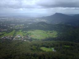
Unanderra is a suburb of Wollongong in New South Wales, Australia. It is located approximately 6 km south-west of the Wollongong CBD. It is bordered to the west by Farmborough, Cordeaux Heights and Farmborough Heights in the Mount Kembla foothills, the north by Figtree, the east by Berkeley and Flagstaff Hill, site of the Nan Tien Temple, and the south by Kembla Grange.

Ballajura is a suburb of Perth, Western Australia, in the City of Swan local government area. Ballajura is located 14 kilometres (8.7 mi) north of the Perth central business district. Situated on its side of its western boundary with Koondoola is Emu Swamp.

Unanderra railway station is located on the South Coast railway line in the Wollongong suburb of Unanderra, New South Wales, Australia.

The Illawarra escarpment, or officially the Illawarra Range, is the fold-created cliffs and plateau-eroded outcrop mountain range west of the Illawarra coastal plain south of Sydney, in the state of New South Wales, Australia. The range encloses the Illawarra region which stretches from Stanwell Park in the north to Kiama, Gerringong and the Shoalhaven River in the south.
Wollongong is an electoral district of the Legislative Assembly in the Australian state of New South Wales. It is represented by Paul Scully of the Labor Party. Since a redistribution in 2013, it has covered an area of 79.25 square kilometres and includes the localities of Berkeley, Coachwood Park, Coniston, Cordeaux Heights, Corrimal, Cringila, Fairy Meadow, Farmborough Chase, Farmborough Heights, Figtree, Gwynneville, Kembla Grange, Kembla Heights, Kemblawarra, Lake Heights, Lindsay Heights, Mangerton, Mount Kembla, Mount Saint Thomas, North Wollongong, Port Kembla, Primbee, Spring Hill, Towradgi, Unanderra, Warrawong, West Wollongong, Windang, Wollongong.

Oak Flats is a suburb of Shellharbour, New South Wales, Australia situated on the south western shores of Lake Illawarra and within the Illawarra region of New South Wales. It is a residential area, which had a population of 6,415 at the 2016 census.

Coalcliff is a town on the coast of New South Wales, Australia, between Sydney and Wollongong.
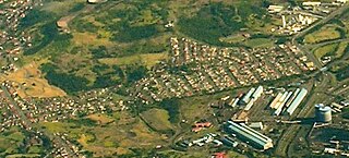
Cringila is a southern suburb of the city of Wollongong, New South Wales, Australia. The suburb is bounded by Berkeley, Unanderra, Lake Heights and Warrawong.
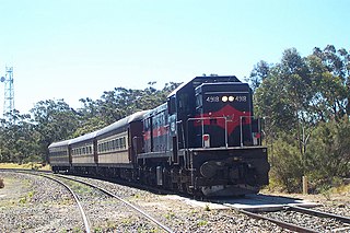
The Unanderra–Moss Vale railway line is a cross country railway line in New South Wales, Australia. The line branches from the Illawarra line at Unanderra and winds west up the Illawarra escarpment to join the Main South line at Moss Vale. The line is one of the most scenic in New South Wales, and for the first 20 km (12 mi) after leaving Unanderra has an almost continuous grade 1 in 30 providing extensive views over the Illawarra coastline.
Cordeaux Heights is a suburb in the city of Wollongong, New South Wales, Australia. It is situated on the eastern foothills of Mount Kembla as is its southern neighbour Farmborough Heights. Its northern boundary of housing is along Cordeaux Road which goes to Mount Kembla Village. Cordeaux Heights has several shops, including a cafe, supermarket/takeaway, bottle shop, hairdresser, dentist and pizzeria.

Figtree is an inner western suburb of Wollongong, New South Wales, Australia. It is south-west of West Wollongong and connected to Wollongong by the Princes Highway
Kembla Heights is a village west of Wollongong, New South Wales in the Parish of Kembla County of Camden. It is situated along Harry Graham Drive and upper Cordeaux Road and is part of a tourist route that runs along the Illawarra escarpment for a distance between Mount Kembla and Mount Keira. The Dendrobium Colliery is located in Kembla Heights.
Summit Tank is a railway platform on the Unanderra–Moss Vale line in the Southern Highlands of New South Wales, Australia. The platform is located on the main line; there is an active passing loop and perway siding beside it.

Port Kembla is a man-made cargo port or artificial harbour, with an outer harbour protected by breakwaters and an inner harbour constructed by dredging, located in the Illawarra region of New South Wales, Australia.
