Corrimal, New South Wales

Last updated

Corrimal
Wollongong,  New South Wales
Corrimal to Tarrawanna.jpg
Aerial photo of Corrimal to Tarrawanna
Australia New South Wales location map blank.svg
Red pog.svg
Corrimal
Coordinates 34°22′S150°53.5′E / 34.367°S 150.8917°E / -34.367; 150.8917
Population6,519 (2016 census) [1]
Postcode(s) 2518
Elevation25 m (82 ft)
Location
LGA(s) City of Wollongong
State electorate(s)
Federal division(s) Cunningham
Suburbs around Corrimal:
Russell Vale Bellambi
Corrimal East Corrimal
Tarrawanna Fernhill Towradgi

Corrimal is a suburb north of the city of Wollongong, New South Wales, Australia. Corrimal's CBD is situated on the Princes Highway, and several streets adjacent to it. The main shopping centres are Lederer Corrimal and Corrimal Park Mall next to the park on the main thoroughfare of Corrimal itself. Outside this centre is an old locomotive that is affectionately known as "The Green Frog". Corrimal's welcome signs feature The Green Frog, as it ran on the Bulli Colliery Line to Bellambi Haven from 1909 to 1967. To the west is a lawn bowls club and a wealthy foothill neighbourhood of residences bordering bushland.

Contents

Corrimal is served by Corrimal railway station on the Illawarra railway line, located on Railway Street which connects the station to the heart of the town. Immediately west of Corrimal railway station is the Corrimal Cokeworks, after 100 years of operation it closed in 2014. The towers are a prominent local sight and can be seen from Wollongong. The railway crosses the first level crossing north of Wollongong immediately north of the station. On the second Sunday in September Corrimal hosts the annual Spring Into Corrimal family festival, which includes market stalls on the closed main streets, a parade, contest and other activities. 2009 was the 30th anniversary of the parade. In the 2007 festival, the world's largest skateboard was displayed. In 2018 the attendance rate was approx. 70,000 people and cemented "Spring into Corrimal" as the largest one day free family festival in Regional NSW. [2]

Corrimal's community is serviced by Corrimal Chamber of Commerce (CCC), a volunteer organisation that formed in 1949 who then supported the businesses houses. In 2014 the new President (Paul Boultwood) and his committee developed a community arm to also help the citizens of the area. The Corrimal Chamber of Commerce was instrumental in making Corrimal the first autism-friendly community in Australia. Since 2014 CCC has won the best Local Chamber of Commerce in the Illawarra 3 times (2014, 2018, 2019) and won the prestigious Best Local Chamber in NSW for 2018/2019. Also looking after the community is Corrimal Region Action Group (CRAG) (formally Corrimal Revitalization Action Group), a volunteer organization that is made up of community citizens and organizations for the betterment of Corrimal and surrounding suburbs. CRAG continues to work with Wollongong City Council to revitalize the township. CRAG were instrumental in developing the "Corrimal Town Centre Plan 2015-2025" along with Council. CRAG is a true volunteer organization that has no alignment to any political group and strives to work only for the citizens and area.

Corrimal is the birthplace of ice cream manufacturer Streets. Edwin (Ted) Street started making ice cream in a small churn, just after the depression, to supply his milk bar. It tasted so good that other shops wanted to buy it and before long, Mr. Street was supplying ice cream to dozens of shops in and out of the area. He built an ice works and factory near the corner of Princes Highway and Tarrawanna Road. Many locals still remember the huge neon sign, featuring a polar bear licking an ice cream outside the Corrimal Works (The first moving neon sign in Wollongong). Streets was sold to Unilever in 1960 and is still in operation.

1891- Corrimal Cougars Cricket Club and Corrimal Rangers Football Club established. 1912- Corrimal Cougars Rugby League team established, in the 1930s, Arthur Ziems donates land next to his butchery for a rugby league field. [3]

Corrimal has four primary schools and one high school. St Columbkille's is Corrimal's local Roman Catholic school. There is also Corrimal Public School, Illawarra Adventist School, Corrimal High School and Aspect, a school for children with autism. [4] [5]

History

The suburb takes its name from a point on the bordering Illawarra escarpment which was known as Mount Corrimal (named after the Aboriginal Dreamtime warrior Kurimul) and now called Broker's Nose. [6] It could also mean Black Mountain (corri mala) as it is a coal belt. The first industry and settlement at Corrimal was that of logging, followed by mining operations. In 1830 the first grant of land was made, to James Martin, of 50 acres (200,000 m2). Corrimal was first recorded in 1839 when a grant was sold at Corrimal. In 1834 the Bulli Parish road was made with convict labour, directed by Major Mitchell. In 1883 Thomas Bertram opened the Corrimal colliery, [7] also known as the Corrimal-Balgownie Colliery. [8]

Corrimal station opened in 1887, when bullock teams ceased transporting coal from the mine to the railway and were replaced by a private colliery mine constructed by the Southern Coal Company, which had taken over operations from Bertram. In 1889 Broker's Nose Colliery was renamed Corrimal Colliery, which closed in 1985. Streets ice cream was founded there in the 1930s.

Politics

Stephen Martin of the Australian Labor Party served as Corrimal's federal MP in the Australian House of Representatives for 18 years from 1984 until his resignation in 2002. Martin served as Speaker of the House under the Keating government from 4 May 1993 to 29 January 1996. The present Federal MP is Alison Byrnes, also of Labor. In state politics Ryan Park is the member for Keira and at time of writing Ryan is the Shadow minister for Health and the Shadow Minister for the Illawarra.

Corrimal was formerly in the seat of Macarthur, until the 1993 redistribution transferred it to Cunningham.

Sport

The most popular sport in the suburb is rugby league, with the local team, the Corrimal Cougars, representing Corrimal in the Illawarra Rugby League competition. Winners of First Grade titles in 1948 and 1974, the club plays its home games at Ziems Park.

Related Research Articles

<span class="mw-page-title-main">Wollongong</span> City in New South Wales, Australia

Wollongong, colloquially referred to as The Gong, is a city located in the Illawarra region of New South Wales, Australia. The name is believed to originate from the Dharawal language, meaning either 'five islands/clouds', 'ground near water' or 'sound of the sea'. Wollongong lies on the narrow coastal strip between the Illawarra Escarpment and the Pacific Ocean, 85 kilometres south of central Sydney. Wollongong had an estimated urban population of 302,739 at June 2018, making it the third-largest city in New South Wales after Sydney and Newcastle and the tenth-largest city in Australia by population. The city's current Lord Mayor is Gordon Bradbery AM who was elected in 2021.

<span class="mw-page-title-main">Bulli, New South Wales</span> Suburb of Wollongong, New South Wales, Australia

Bulli is a northern suburb of Wollongong situated on the south coast of New South Wales, Australia.

<span class="mw-page-title-main">Mount Keira</span> Suburb of Wollongong, New South Wales, Australia

Mount Keira is a suburb and mountain in the Illawarra region of New South Wales, Australia.

<span class="mw-page-title-main">Stanwell Park, New South Wales</span> Suburb of Wollongong, New South Wales, Australia

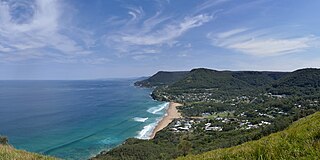
Stanwell Park is a coastal village and northern suburb of Wollongong, New South Wales, Australia. It is the northernmost point of the Illawarra coastal strip and lies south of Sydney's Royal National Park. It is situated in a small valley between Bald Hill to the north, Stanwell Tops to the west and Mount Mitchell to the south. It has two lagoons from the village's two creeks, Stanwell and Hargrave Creeks and a beach running between headlands. Stanwell Park and the surrounding suburbs are colloquially referred to by its postcode 2508.

<span class="mw-page-title-main">Towradgi, New South Wales</span> Suburb of Wollongong, New South Wales, Australia

Towradgi is a small beach-side suburb approximately 5 km (3.1 mi) north of Wollongong, New South Wales, Australia. Towradgi is derived from the Dharawal word Kow-radgi, meaning "guardian of the sacred stones". On an early map it was called Towroger. Towradgi is served by electric trains at Towradgi railway station, opened in 1948.

<span class="mw-page-title-main">Thirroul, New South Wales</span> Suburb of Wollongong, New South Wales, Australia

Thirroul is a northern seaside suburb of the city of Wollongong, Australia. Situated between Austinmer and Bulli, it is approximately 13 kilometres north of Wollongong, and 73 km south of Sydney. It lies between the Pacific Ocean and a section of the Illawarra escarpment known as Lady Fuller Park, adjacent to Bulli Pass Scenic Reserve.

<span class="mw-page-title-main">Bulli railway station</span> Railway station in New South Wales, Australia

Bulli railway station is a heritage-listed railway station on the South Coast railway line in New South Wales, Australia, serving the northern Wollongong suburb of Bulli. It was added to the New South Wales State Heritage Register on 30 August 2013.

<span class="mw-page-title-main">Woonona, New South Wales</span> Suburb of Wollongong, New South Wales, Australia

Woonona is a suburb north of Wollongong, New South Wales, Australia, south of Sydney. It is served by Woonona Station on the South Coast Line, and by the Princes Highway.

<span class="mw-page-title-main">North Wollongong railway station</span> Railway station in Australia

North Wollongong railway station is located on the South Coast railway line in New South Wales, Australia. It serves the Northern Wollongong suburb of North Wollongong, opening on 19 July 1915. It is the primary station for the University of Wollongong.

<span class="mw-page-title-main">Coalcliff, New South Wales</span> Suburb of Wollongong, New South Wales, Australia

Coalcliff is a town on the coast of New South Wales, Australia, between Sydney and Wollongong.

<span class="mw-page-title-main">Illawarra Rugby League</span>

The Illawarra Rugby League is a rugby league competition in Wollongong, NSW. It is one of the oldest rugby league competitions in Australia, founded in 1911 with five clubs. The area provides a nursery of juniors for the Illawarra Steelers and St George Illawarra Dragons. The season is contested by seven teams and concludes with a finals series involving the top four teams.

<span class="mw-page-title-main">Austinmer, New South Wales</span> Suburb of Wollongong, New South Wales, Australia

Austinmer is a northern village of Wollongong on the south coast of New South Wales, Australia. It sits in the northern Illawarra region, south of Stanwell Park and immediately north of Thirroul.

<span class="mw-page-title-main">Scarborough, New South Wales</span> Suburb of Wollongong, New South Wales, Australia

Scarborough is a small northern seaside suburb of Wollongong on the south coast of New South Wales, Australia. It sits in the northern Illawarra region on a narrow stretch between the Illawarra escarpment and sea cliffs.

<span class="mw-page-title-main">Cringila, New South Wales</span> Suburb of Wollongong, New South Wales, Australia

Cringila is a southern suburb of the city of Wollongong, New South Wales, Australia. The suburb is bounded by Berkeley, Unanderra, Lake Heights and Warrawong.

<span class="mw-page-title-main">Bellambi, New South Wales</span> Suburb of Wollongong, New South Wales, Australia

Bellambi is a suburb of Wollongong in the Illawarra region of New South Wales, Australia. It has a railway station on the NSW TrainLink South Coast Line.

<span class="mw-page-title-main">East Corrimal, New South Wales</span> Suburb of Wollongong, New South Wales, Australia

East Corrimal is a northern seaside suburb of Wollongong, New South Wales, Australia. Predominantly residential, the suburb includes Corrimal High School and Corrimal East Public School, as well as Corrimal Beach and Corrimal Beach Tourist Park at the eastern end. A public park was opened in 1959 to the west of the high school and north of the primary school, named Phil Adams Park, which features tall trees, paths and several seats.

<span class="mw-page-title-main">Berkeley Eagles</span> Australian rugby league club, based in Berkeley, NSW

The Berkeley Eagles are an Australian rugby league football team based in Berkeley, a suburb of Wollongong. The club are a part of Country Rugby League and has competed in the Illawarra competition.

<span class="mw-page-title-main">Corrimal Cougars</span> Australian rugby league club, based in Corrimal, NSW

The Corrimal Cougars are an Australian rugby league football team based in Corrimal, a northern suburb of the city of Wollongong. The club are a part of Country Rugby League and has competed in the Illawarra Rugby League premiership since 1912.

<span class="mw-page-title-main">Port Kembla harbour</span> Port in Australia

Port Kembla is a man-made cargo port or artificial harbour, with an outer harbour protected by breakwaters and an inner harbour constructed by dredging, located in the Illawarra region of New South Wales, Australia.

References

  1. Australian Bureau of Statistics (27 June 2017). "Corrimal (State Suburb)". 2016 Census QuickStats. Retrieved 16 July 2017. OOjs UI icon edit-ltr-progressive.svg
  2. Corrimal Chamber of Commerce
  3. Corrimal Town Centre Plan, Wollongong City Council 2015.
  4. "HUNTER SCHOOL FOR CHILDREN WITH AUTISM" . Retrieved 4 February 2012.
  5. Autism Spectrum Australia (Aspect). "AspectSouthCoastSchool" . Retrieved 4 February 2012.
  6. "Place names of the Wollongong region". Wollongong City Council. Archived from the original on 30 December 2008. Retrieved 7 March 2009.
  7. The Corrimal Railway Singleton, C.C. Australian Railway Historical Society Bulletin January 1957 pp1-7
  8. The Corrimal Colliery Railway Light Railways issue 60 April 1978 pages 5-44