
Wollongong is a city located in the Illawarra region of New South Wales, Australia. The name is believed to originate from the Dharawal language, meaning either 'five islands/clouds', 'ground near water' or 'sound of the sea'. Wollongong lies on the narrow coastal strip between the Illawarra Escarpment and the Pacific Ocean, 85 kilometres south of central Sydney. Wollongong had an estimated urban population of 302,739 at June 2018, making it the third-largest city in New South Wales after Sydney and Newcastle and the tenth-largest city in Australia by population. The city's current Lord Mayor is Tania Brown who was elected in 2024.
Dapto is a suburb of Wollongong in the Illawarra region of New South Wales, Australia, located on the western side of Lake Illawarra and covering 7.15 square kilometres (2.76 sq mi). As at the 2021 census, the suburb had a population of 10,954.

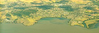
The Illawarra is a coastal region in the southeast of the Australian state of New South Wales. It is situated immediately south of Sydney and north of the South Coast region. It encompasses the two cities of Wollongong, Shellharbour and the coastal town of Kiama. Wollongong is the largest city of the Illawarra with a population of 240,000, then Shellharbour with a population of 70,000 and Kiama with a population of 10,000. These three cities have their own suburbs. Wollongong stretches from Otford in the north to Windang in the south, with Maddens Plains and Cordeaux in the west.

Mount Waverley is a suburb in Melbourne, Victoria, Australia, 16 km (9.9 mi) south-east of Melbourne's Central Business District, located within the City of Monash local government area. Mount Waverley recorded a population of 35,340 at the 2021 census.
Shellharbour is a suburb located in the Illawarra region of New South Wales, Australia. It also gives its name to the local government area, City of Shellharbour, and its central business district, Shellharbour City Centre.
Albion Park is a suburb situated in the Macquarie Valley in the City of Shellharbour, which is in turn one of the three local government areas that comprise the Wollongong Metropolitan Area, New South Wales, Australia. Although it is surrounded by a 'green belt' of farms, Albion Park had a population of 13,316 at the 2016 census.

Mortdale is a suburb located in southern Sydney, in the state of New South Wales, Australia. Mortdale is located 20 kilometres south of the Sydney central business district and is part of the St George area. Mortdale is situated in the local government area of Georges River Council. Mortdale extends south to Lime Kiln Bay, on the Georges River. Mortdale Heights is a locality in the western corner of the suburb.
Warilla High School is a government-funded co-educational comprehensive secondary day school, located in Barrack Heights, a suburb of the City of Shellharbour, in the Illawarra region of New South Wales, Australia.

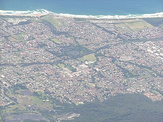
The City of Shellharbour is a local government area in the Illawarra region of New South Wales, Australia. The city is located about 100 kilometres (62 mi) south of Sydney and covers the southern suburbs of the Wollongong urban area centred on Shellharbour and it had an estimated population of 68,460 at the 2016 census.

Oak Flats is a suburb of Shellharbour, New South Wales, Australia situated on the south western shores of Lake Illawarra and within the Illawarra region of New South Wales. It is a residential area, which had a population of 6,840 at the 2021 census.

South Coast Group 7 Rugby League is the divisional boundary drawn from the Southern Illawarra and South Coast regions of New South Wales, Australia and is governed by the NSWCRL. The main semi-professional competition,, comprises ten (10) teams from across the region. Group 7 Rugby League also administers reserve grade, third grade, and under-18s competitions, Ladies League Tag, as well as looking over many junior competitions.
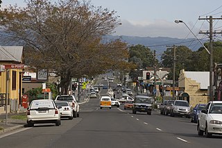
Corrimal is a suburb north of the city of Wollongong, New South Wales, Australia. Corrimal's CBD is situated on the Princes Highway, and several streets adjacent to it. The main shopping centres are Lederer Corrimal and Corrimal Park Mall next to the park on the main thoroughfare of Corrimal itself. Outside this centre is an old locomotive that is affectionately known as "The Green Frog". Corrimal's welcome signs feature The Green Frog, as it ran on the Bulli Colliery Line to Bellambi Haven from 1909 to 1967. To the west is a lawn bowls club and a wealthy foothill neighbourhood of residences bordering bushland.
Shellharbour is an electoral district of the Legislative Assembly in the Australian state of New South Wales. It is represented by Anna Watson who won Labor preselection after the former member Lylea McMahon decided not to contest the 2011 election.

Barrack Heights is a suburb of the City of Shellharbour in New South Wales, Australia in the local government area of the same name. Many institutions are located in Barrack Heights, including Shellharbour Public Hospital, Shellharbour Private Hospital, Warilla Bowling Club, Warilla Sports Club and Warilla High School.

Mount Warrigal is a large suburb of Shellharbour, New South Wales, Australia. The population, according to the 2021 Australian Census, was 4,880. The suburb is in the Shellharbour City LGA.

Kane Linnett is a retired Scotland international rugby league footballer, who plays as a centre or second-row forward for Sarina Crocodiles in the Mackay & District Rugby League.

The Shellharbour City Sharks are a Country Rugby League club founded in 1920 located on the South Coast of NSW that compete in the South Coast Group 7 competition.

The Warilla-Lake South Gorillas are an Australian rugby league football team based in Lake Illawarra, a coastal town of the Illawarra region. The club is a part of Country Rugby League and have competed in the South Coast first grade competition since 1970. The club's greatest achievement to date is winning the Clayton Cup in 1982.
Barrack Point is a seaside suburb of the City of Shellharbour, New South Wales, Australia which sits within the southern Wollongong urban area. Surrounding suburbs are Warilla to the north, Barrack Heights to the west, and Shellharbour to the south.


