
Bomaderry is a suburb in the City of Shoalhaven local government area in New South Wales, Australia. At the 2021 census, it had a population of 8,718 people. It is on the north shore of the Shoalhaven River, across the river from Nowra, the major town of the City of Shoalhaven, of which Bomaderry is locally regarded as being a suburb of the city.
Cooranbong is a town in a suburb of the City of Lake Macquarie, Greater Newcastle in New South Wales, Australia, west of the town of Morisset off the M1 Pacific Motorway. Cooranbong is surrounded by the Watagans National Park.
Charlestown is a suburb of the City of Lake Macquarie, New South Wales, Australia, and the largest suburb in Lake Macquarie and in the Greater Newcastle area. It is approximately 10 kilometres (6 mi) west-south-west of the central business district of Newcastle.

The Welsh are an ethnic group native to Wales. Wales is one of the four countries of the United Kingdom. The majority of people living in Wales are British citizens.

Hebersham is a suburb of Sydney, in the state of New South Wales, Australia. Hebersham is located 47 kilometres west of the Sydney central business district, in the local government area of the City of Blacktown and is part of the Greater Western Sydney region.

Rosehill is a suburb of Sydney, in the state of New South Wales, Australia. Rosehill is located 18 kilometres west of the Sydney central business district in the local government area of the City of Parramatta and is part of the Greater Western Sydney region.

North Parramatta is a suburb on the North Shore of Sydney, in the state of New South Wales, Australia. North Parramatta is 24 kilometres north-west of the Sydney central business district in the local government area of the City of Parramatta.

Wareemba is a suburb in the Inner West of Sydney in the state of New South Wales, Australia. Wareemba is 12 kilometres west of the Sydney central business district in the local government area of the City of Canada Bay. Wareemba sits on the eastern shore of Hen and Chicken Bay, on the Parramatta River. It is almost the smallest suburb in Sydney by land area.

Denistone West is a suburb in Northern Sydney, in the state of New South Wales, Australia. Denistone West is located 16 kilometres north-west of the Sydney central business district in the local government area of the City of Ryde. Denistone and Denistone East are separate suburbs; Denistone West was gazetted as a suburb in its own right on 5 February 1999.
Culburra Beach, commonly referred to as Culburra, is a town located in the South Coast region of New South Wales, Australia. Located within the Shoalhaven local government area, the town is 18 kilometres (11 mi) east-southeast of Nowra on Jerrinja Wandi Wandian Aboriginal Country. At the 2016 census, the town had a population of 2,874 and is the regional centre for the coastal villages of Currarong, Callala Beach, Callala Bay and Orient Point.

Sinnamon Park is a suburb in the City of Brisbane, Queensland, Australia. In the 2016 census, Sinnamon Park had a population of 6,419 people.

Lake Conjola is a small town situated on the South Coast of New South Wales, Australia. It is located in the region of Ulladulla, in the City of Shoalhaven. At the 2016 census, Lake Conjola had a population of 437. Lake Conjola is a popular tourist destination for boaters and fisherman. Fish in the lake include bream, whiting, tailor, flathead, luderick and jewfish. Lake Conjola is located on the southern side of Green Island, a renowned surf break. There are four caravan parks with cabins, caravan areas, tent areas, and waterfronts.
Adamstown is a suburb of Newcastle, New South Wales, Australia, located 6 kilometres (4 mi) from Newcastle's central business district. It is split between the City of Newcastle and City of Lake Macquarie local government areas.
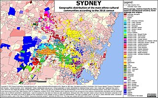
Sydney is Australia's most populous city, and is also the most populous city in Oceania. In the 2021 census, 5,231,147 persons declared themselves as residents of the Sydney Statistical Division–about one-fifth (20.58%) of Australia's total population. With a population density of 2037 people per square kilometre, the urban core has population density five times that of the greater region.

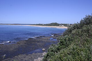
Shoalhaven Heads is a town in Shoalhaven, New South Wales, Australia. At the 2016 census, Shoalhaven Heads had a population of 3,059 people. It has a surfing beach, access to the Shoalhaven River and is surrounded by wineries.
Batehaven is a locality approximately 4 kilometres (2 mi) from Batemans Bay in south-central New South Wales.
Calderwood is a suburb in the City of Shellharbour in New South Wales, Australia, lying to the northwest of Albion Park. At the 2021 census, Calderwood had a population of 3,013. It is currently undergoing suburban redevelopment through Lendlease.

Ellalong 'The Jewel of the Mountain' is a small town located in the Hunter Region of New South Wales, Australia at the foot of the Watagan Mountains.
The 2016 Australian census was the 17th national population census held in Australia. The census was officially conducted with effect on Tuesday, 9 August 2016. The total population of the Commonwealth of Australia was counted as 23,401,892 – an increase of 8.8 per cent or 1,894,175 people over the 2011 census. Norfolk Island joined the census for the first time in 2016, adding 1,748 to the population.
Punjabi Australians are Australians who are of Punjabi descent. According to the 2016 census, Punjabi is one of the fastest-growing languages in Australia, with 132,499 individuals identifying as Punjabi-speakers. This is an increase from 71,230 individuals in 2011 and 26,000 individuals in 2006, representing a five-fold growth in 10 years.
