
The Jervis Bay Territory is an internal territory of the Commonwealth of Australia. It was surrendered by the state of New South Wales to the Commonwealth Government in 1915 so that the Australian Capital Territory would have access to the sea.

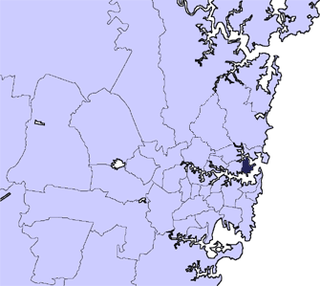
The City of Shoalhaven is a local government area in the south-eastern coastal region of New South Wales, Australia. The area is approximately 200 kilometres (120 mi) south of Sydney. The area is located adjacent to the Tasman Sea. The Princes Highway passes through the area and the South Coast railway line traverses the northern section of the area and terminates at Bomaderry. At the 2016 census, the population of the City of Shoalhaven was 99,650.

Hayward is a city located in Alameda County, California in the East Bay subregion of the San Francisco Bay Area. With a 2019 population of 159,203, Hayward is the sixth largest city in the Bay Area and the third largest in Alameda County. Hayward was ranked as the 32nd most populous municipality in California. It is included in the San Francisco–Oakland–Fremont Metropolitan Statistical Area by the US Census. It is located primarily between Castro Valley, San Leandro and Union City, and lies at the eastern terminus of the San Mateo–Hayward Bridge. The city was devastated early in its history by the 1868 Hayward earthquake. From the early 20th century until the beginning of the 1980s, Hayward's economy was dominated by its now defunct food canning and salt production industries.

The City of Lake Macquarie is a local government area in the Hunter Region of New South Wales, Australia and was proclaimed a city from 7 September 1984. The area is situated adjacent to the city of Newcastle and is part of the Greater Newcastle Area. The city is approximately 150 km (93 mi) north of Sydney. One of its major tourist attractions is its lake, also named Lake Macquarie.
The City of Botany Bay was a local government area in the eastern region of Sydney, in the state of New South Wales, Australia. The area encompassed the suburbs to the north of Botany Bay, such as Botany. First proclaimed in 1888 as the "Borough of Botany", the council became the "Municipality of Botany" from 1906 to 1996, when it was proclaimed a city as the "City of Botany Bay".
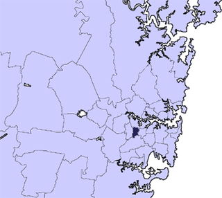
The City of Kogarah was a local government area in the St George region of southern Sydney, in the state of New South Wales, Australia. The centre of the city is located 14 kilometres (8.7 mi) south-west of the Sydney central business district and west of Botany Bay.

The City of Willoughby is a local government area on the Lower North Shore of Northern Sydney, in the state of New South Wales, Australia. It is located 6 kilometres (3.7 mi) north of the Sydney central business district. It was first proclaimed in October 1865 as the Municipality of North Willoughby.
The City of Canada Bay is a local government area in the Inner West of Sydney, New South Wales, Australia. The city was formed on 1 December 2000, following the merger of Concord and Drummoyne councils. The city covers an area of 19.82 square kilometres (7.65 sq mi) and as at the 2016 census had a resident population of 88,015. The city is ultimately named after Canada Bay, a bay on the Parramatta River.
The Municipality of Burwood is a local government area in the inner-west of Sydney, in the state of New South Wales, Australia.
The Mosman Council is a local government area on the Lower North Shore of Sydney, New South Wales, Australia.

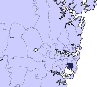
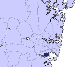
The City of Randwick is a local government area in the eastern suburbs of Sydney, New South Wales, Australia. Established in 1859, Randwick is the second-oldest local government area in New South Wales, after the City of Sydney. It comprises an area of 36 square kilometres (14 sq mi) and as at the 2016 census had a population of 140,660.

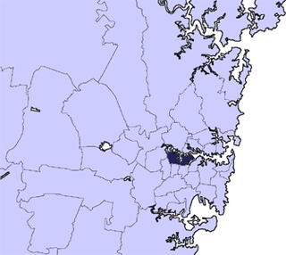
Woollahra Municipal Council is a local government area in the eastern suburbs of Sydney, in the state of New South Wales, Australia. Woollahra is bounded by Sydney Harbour in the north, Waverley Council in the east, Randwick City in the south and the City of Sydney in the west.

The states and territories of Australia are the second level of government division in Australia, between the federal government and local governments. States and territories are self-administered regions with a local legislature, police force and certain civil authorities, and are represented in the Parliament of Australia. Territories though, unlike states, rely on federal legislation and additional financial contributions to operate, and have less representation in the Senate.

Port Stephens Council is a local government area in the Hunter Region of New South Wales, Australia. The area is just north of Newcastle and is adjacent to the Pacific Highway which runs through Raymond Terrace, the largest town and Council seat. The area is named after Port Stephens, which is the major geographical feature of the area. It extends generally from the Hunter River in the south, to near Clarence Town in the north, and from the Tasman Sea in the east, to just south of Paterson in the west. The mayor of Port Stephens Council is Ryan Palmer. Port Stephens is about two and a half hours north of Sydney.

Sussex Inlet is a town in the South Coast region of New South Wales, Australia. The town lies on the west bank of the waterway called Sussex Inlet, which divides New South Wales from the Jervis Bay Territory. The town lies within the City of Shoalhaven.
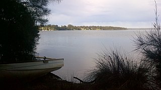
Erowal Bay is a small town in the Shoalhaven local government area on the New South Wales south coast, on the northern side of St Georges Basin. It lies west of Hyams Beach and east of Old Erowal Bay. At the 2016 census, Erowal Bay had a population of 623.

The Northern Beaches Council is a local government area located in the Northern Beaches region of Sydney, in the state of New South Wales, Australia. The Council was formed on 12 May 2016 after the amalgamation of Manly, Pittwater and Warringah Councils.

The Georges River Council is a local government area located in the St George region of Sydney located south of the CBD, in New South Wales, Australia. The Council was formed on 12 May 2016 from the merger of the Kogarah City Council and Hurstville City Council.

Bayside Council is a local government area located around Botany Bay which is split between the eastern suburbs and St George areas of Sydney, located between 7 kilometres (4.3 mi) and 12 kilometres (7.5 mi) south of the CBD in the state of New South Wales, Australia. The Council was formed on 9 September 2016 from the merger of the City of Botany Bay and the Rockdale City Councils.

East Palmerston is a rural locality in the Cassowary Coast Region, Queensland, Australia. In the 2016 census East Palmerston had a population of 173 people.
