
The City of Lake Macquarie is a local government area in the Hunter Region of New South Wales, Australia and was proclaimed a city from 7 September 1984. The area is situated adjacent to the city of Newcastle and is part of the Greater Newcastle Area. The city is approximately 150 km (93 mi) north of Sydney. One of its major tourist attractions is its lake, also named Lake Macquarie.
Liverpool is a suburb of Greater Western Sydney, in the state of New South Wales, Australia. It is located 27 kilometres (17 mi) south-west of the Sydney CBD. Liverpool is the administrative seat of the local government area of the City of Liverpool and is situated in the Cumberland Plain.
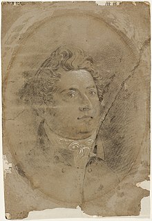
Francis Howard Greenway was an English-born architect who was transported to Australia as a convict for the crime of forgery. In New South Wales he worked for the Governor, Lachlan Macquarie, as Australia's first government architect. He became widely known and admired for his work displayed in buildings such as St Matthew's Church in Windsor, New South Wales, St James' Church, Sydney and Hyde Park Barracks, Sydney.
Mount Hutton is a suburb of the City of Lake Macquarie, New South Wales, Australia, located 14 kilometres (9 mi) from Newcastle's central business district on the eastern side of Lake Macquarie. It is part of the City of Lake Macquarie North Ward.

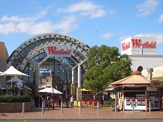
Macquarie Park is a suburb in northern Sydney, New South Wales, Australia. Macquarie Park is located 15 kilometres north-west of the Sydney central business district in the local government area of the City of Ryde. Macquarie Park is part of the Northern Suburbs region.

Port Macquarie-Hastings Council is a local government area in the mid north coast region of New South Wales, Australia.

Speers Point is a suburb within, and the location of the council seat of the City of Lake Macquarie local government area in New South Wales, Australia. It is 17 kilometres (10.6 mi) west-southwest of the city of Newcastle on the northern shore of Lake Macquarie, in Cockle and Warners Bays, between the suburbs of Cardiff and Warners Bay.
Windale is a suburb of the city of Lake Macquarie, in the Newcastle metropolitan area. It is located west of the junction of the Pacific Highway and Newcastle Inner City Bypass, covering an area of 1.7 km2 (0.7 sq mi).
Garden Suburb is a suburb of the City of Lake Macquarie in New South Wales 12 kilometres (7 mi) west of Newcastle's central business district in Lake Macquarie's North Ward.
Floraville is a suburb of the City of Lake Macquarie in New South Wales, Australia 17 kilometres (11 mi) from Newcastle's central business district on the eastern side of Lake Macquarie and north of the town of Belmont.
Jewells is a suburb of the City of Lake Macquarie in New South Wales, Australia 15 kilometres (9 mi) from Newcastle's central business district on the eastern side of Lake Macquarie and north-east of the town of Belmont.
Lakelands is a residential suburb of the City of Lake Macquarie, New South Wales, Australia 16 kilometres (10 mi) south-west of Newcastle's central business district near the northern end of Lake Macquarie. It is part of the City of Lake Macquarie west ward, and was formerly part of Warners Bay.
Gateshead is a suburb of the City of Lake Macquarie, New South Wales, Australia, 12 kilometres (7 mi) from Newcastle's central business district on the eastern side of Lake Macquarie. It is part of the City of Lake Macquarie East ward, and is home to a number of primary and high schools and a private hospital. Gateshead is named after Gateshead, a town in North East England.
Kilaben Bay is a suburb of the city of Lake Macquarie in the Hunter Region of New South Wales, Australia. It is named for the bay of the same name that lies to the south of the suburb. The suburb's western boundary is heavily forested. Kilaben Bay is one of many suburbs that ring Lake Macquarie, Lake Munmorah, and Tuggerah Lake. Kilaben Bay is part of the West Ward of the City of Lake Macquarie local government area. For telephone call charges, Kilaben Bay is within the local call zone of the City of Newcastle.
Ingleburn was an electoral district of the Legislative Assembly in the Australian state of New South Wales, created in 1981, and named after and including the Sydney suburb of Ingleburn. It was abolished in 1988 and largely replaced by Macquarie Fields.
Silverwater is a suburb of the City of Lake Macquarie in New South Wales, Australia, and is located on a peninsula east of the town of Morisset on the western side of Lake Macquarie.
Macquarie Hills is a residential suburb of the City of Lake Macquarie, New South Wales, Australia, located 15 kilometres (9 mi) west of Newcastle's central business district near the northern end of Lake Macquarie between the town centres of Cardiff and Warners Bay. It is part of the City of Lake Macquarie north ward.
Cardiff South is a suburb of the City of Lake Macquarie, New South Wales, Australia, located 13 kilometres (8 mi) west-southwest of Newcastle's central business district. It is part of the City of Lake Macquarie north ward.

Peter Board High School, known from 1962-1985 as North Ryde High School, is a former government-funded co-educational comprehensive secondary day school, that was located in North Ryde, a lower north shore suburb of Sydney, New South Wales, Australia. The school opened in 1962 and closed in 1998.


