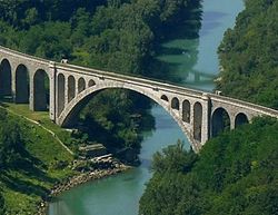
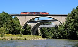
List of longest masonry arch bridge spans

Last updated

The masonry arch bridges of stone or brick are the most genuine of arch bridges, some lasting a thousand years. Because they are made of worked stone, there is a slight chance they might even stand without mortar, like the Pont du Gard aqueduct. Yet arch bridges using rough hewn stones like Changhong Bridge need mortar to stand. Arches with a core of reinforced concrete covered by facade stone for decoration are not to be included in this list, the load-bearing part of the arch should be cut stone or brick, or as follows, unreinforced concrete.

Contents

In a closed spandrel stone arch bridge the hollow space can be filled with rubble and loose material. It can also be filled with concrete, in which case the filling itself become able to bear load in addition to the load carried by the ring of voussoirs. If the voussoir stones are thin they can not take a lot of weight so instead it is the concrete filling that becomes the structural part of the arch. The next step is to remove the voussoir stones completely, or only use them as facade stones. An unreinforced concrete arch is technically a masonry arch that use only very small stones, that is the aggregate of the concrete, sand and gravel. Such an arch would not stand without mortar.

Some modern bridges are built masonry style with precast concrete blocks, like Gladesville Bridge that has a span of 305 metres (1000 ft). These types are not in this list because their blocks are most likely made of reinforced concrete, that may make the assembled arch to have more in common with a modern reinforced concrete arch than a stone masonry arch.

The Maidenhead Railway Bridge may have the two longest arches made of bricks, 39 metres (128 ft).

Building new masonry arch bridges today is a solely Chinese business. There are 18 stone arch bridges with spans exceeding 100 m (330 ft). [1] There are probably several dozens of stone arches exceeding 40m in the Fujian province only. [2] Almost all bridges were built after 1950.

This list contains the longest masonry arch spans ever built being at least 50 metres (164 ft).

   RankNameSpan
metres
Span
feet
NoteYear openedLocationCountryRef
1 Danhe Bridge  [ fr ]
丹河大桥
146 m479 ftConcrete deck
2001
Jincheng, Shanxi
35°28′15.0″N112°59′43.0″E / 35.470833°N 112.995278°E / 35.470833; 112.995278
Flag of the People's Republic of China.svg  China [3] [4]
2 Wuchaohe Bridge
乌巢河大桥
120 m394 ftConcrete deck
1990
Fenghuang County, Hunan
28°04′42.3″N109°23′58.7″E / 28.078417°N 109.399639°E / 28.078417; 109.399639
Flag of the People's Republic of China.svg  China [S 1]
3 Jiuxigou Bridge
九溪溝橋
116 m381 ftConcrete deck
1972
Fengdu County, Chongqing
29°47′09.1″N107°49′27.9″E / 29.785861°N 107.824417°E / 29.785861; 107.824417
Flag of the People's Republic of China.svg  China [S 2]
4 Changhong Bridge
长虹桥
112 m367 ft
1961
Kaiyuan, Yunnan
23°48′55.9″N103°16′34.4″E / 23.815528°N 103.276222°E / 23.815528; 103.276222
Flag of the People's Republic of China.svg  China [S 3]
5 Fushun Tuojiang Bridge
富顺红旗大桥
111 m364 ft
1968
Fushun County, Sichuan
29°10′57.8″N105°00′22.1″E / 29.182722°N 105.006139°E / 29.182722; 105.006139
Flag of the People's Republic of China.svg  China [5]
6 Shengli Bridge
108 m354 ft
1989
Flag of the People's Republic of China.svg  China [5]
7 First Sizhuang Bridge
108 m354 ft
1996
Flag of the People's Republic of China.svg  China [5]
8 Xianfeng Aqueduct Bridge
险峰渡槽
106 m348 ft
1976
Ci County, Hebei
36°25′01.6″N114°05′23.7″E / 36.417111°N 114.089917°E / 36.417111; 114.089917
Flag of the People's Republic of China.svg  China [6]
9 Huwan Bridge
105 m344 ft
1972
Henan Flag of the People's Republic of China.svg  China [7]
10 New Tongshan Bridge
105 m344 ft
1977
Flag of the People's Republic of China.svg  China [5]
11 First Danhe Bridge
105 m344 ft
1983
Flag of the People's Republic of China.svg  China [5]
12 Jiangpinghe Bridge
105 m344 ft
1990
Flag of the People's Republic of China.svg  China [5]
13 Yugong Bridge
102 m335 ft
1970
Flag of the People's Republic of China.svg  China [5]
14 Gongtan Bridge
100 m328 ft
1954
Flag of the People's Republic of China.svg  China [5]
15 Youduhe Bridge
游渡河大桥
100 m328 ft
1973
Jiangjin District, Chongqing
28°52′23.4″N106°20′12.4″E / 28.873167°N 106.336778°E / 28.873167; 106.336778
Flag of the People's Republic of China.svg  China [5]
16 Hongdu Bridge
红渡桥
100 m328 ft
1977
Mashan County - Du'an County, Guangxi
23°50′29.2″N108°09′04.1″E / 23.841444°N 108.151139°E / 23.841444; 108.151139
Flag of the People's Republic of China.svg  China [S 4]
17 Longwu Bridge
100 m328 ft
1979
Guangxi Flag of the People's Republic of China.svg  China [7]
18 Fujin Bridge
100 m328 ft
2003
Flag of the People's Republic of China.svg  China [5]
19 Jianjin Bridge
100 m328 ftFlag of the People's Republic of China.svg  China
20 Daliushu Bridge
100 m328 ftFlag of the People's Republic of China.svg  China
21 Jin-shan Bridge
金山大桥
99 m325 ft
1972
Hua'an County, Fujian
24°55′23.7″N117°30′16.7″E / 24.923250°N 117.504639°E / 24.923250; 117.504639
Flag of the People's Republic of China.svg  China [5]
22 Xiaoduchuan Bridge
现有红江桥
97 m318 ft
1970
Enshi City, Hubei
30°17′50.7″N109°28′45.2″E / 30.297417°N 109.479222°E / 30.297417; 109.479222
Flag of the People's Republic of China.svg  China [8]
Villeneuve-sur-Lot - Pont de la Liberation -122.jpg 23 Pont de la Libération  [ fr ]
96 m315 ftUnreinforced concrete arches
Concrete deck
1919
Villeneuve-sur-Lot, Lot-et-Garonne
44°24′17.2″N0°42′20.5″E / 44.404778°N 0.705694°E / 44.404778; 0.705694
Flag of France.svg  France [S 5]
Syratalviadukt Plauen (Friedensbruecke).jpg 24 Syratal Viaduct  [ de ]
90 m295 ft
1905
Plauen, Saxony
50°29′56.4″N12°07′35.8″E / 50.499000°N 12.126611°E / 50.499000; 12.126611
Flag of Germany.svg  Germany [S 6]
Grutas de Longmen em Luoyang - China (6972397596).jpg 25 Longmen Bridge
龙门大桥
90 m295 ftTwo 60-meter side spans
1961
Luoyang, Henan
34°33′33.0″N112°28′21.4″E / 34.559167°N 112.472611°E / 34.559167; 112.472611
Flag of the People's Republic of China.svg  China [S 7]
Solkanski most cez Soco2.jpg 26 Solkan Bridge 85 m279 ftDestroyed in 1916
Rebuilt in 1927
1906
Nova Gorica, Goriška
45°58′43.5″N13°39′06.3″E / 45.978750°N 13.651750°E / 45.978750; 13.651750
Flag of Slovenia.svg  Slovenia [S 8]
Adolphe Bridge over the valley of Petrusse in Luxembourg City.jpg 27 Adolphe Bridge 84 m276 ftConcrete deck
1904
Luxembourg City
49°36′30.5″N6°07′36.9″E / 49.608472°N 6.126917°E / 49.608472; 6.126917
Flag of Luxembourg.svg  Luxembourg [S 9]
Pont des pierres - Montanges-1-edit.jpg 28 Bridge of Stones  [ fr ]
Pont des Pierres
80 m262 ftDestroyed in 1944
1910
Montanges, Ain
46°09′55.0″N5°48′40.3″E / 46.165278°N 5.811194°E / 46.165278; 5.811194
Flag of France.svg  France [S 10]
Viaduc de Roizonne (32238881910)2.jpeg 29 Roizonne Viaduct  [ fr ]
79 m259 ft
1928
La Mure, Isère
44°54′51.0″N5°49′44.7″E / 44.914167°N 5.829083°E / 44.914167; 5.829083
Flag of France.svg  France [S 11]
Castello di Trezzo1.JPG 30 Trezzo sull'Adda Bridge 72 m236 ftDestroyed in 1416
1377
Trezzo sull'Adda, Lombardy
45°36′43.8″N9°31′24.7″E / 45.612167°N 9.523528°E / 45.612167; 9.523528
Flag of Italy.svg  Italy [S 12]
Klaus Steyrling Brucke Pyhrnbahn.JPG 31 Steyrling Bridge 70 m230 ft
1904
Steyrling, Upper Austria
47°48′15.4″N14°09′47.5″E / 47.804278°N 14.163194°E / 47.804278; 14.163194
Flag of Austria.svg  Austria [9]
qnTr@ sydy rshd wlzwy@.JPG 32 Sidi Rached Bridge  [ fr ]
68 m223 ft
1912
Constantine, Constantine Province
36°21′45.1″N6°36′49.6″E / 36.362528°N 6.613778°E / 36.362528; 6.613778
Flag of Algeria.svg  Algeria [S 13]
Union Arch Bridge MD 2008.jpg 33 Union Arch Bridge 67 m220 ft
1864
Cabin John, Maryland
38°58′22.1″N77°08′54.8″W / 38.972806°N 77.148556°W / 38.972806; -77.148556
Flag of the United States (23px).png  United States [S 14]
Sonnborner + Siegfriedstrasse 03 ies.jpg 34 Sonnborner Eisenbahnbrücke  [ de ]
66 m217 ft
1914
Wuppertal, North Rhine-Westphalia
51°14′30.4″N7°06′11.3″E / 51.241778°N 7.103139°E / 51.241778; 7.103139
Flag of Germany.svg  Germany [S 15]
Veresk Bridge 3.jpg 35 Veresk Bridge 66 m217 ft
1936
Veresk, Mazandaran Province
35°54′12.0″N52°59′24.9″E / 35.903333°N 52.990250°E / 35.903333; 52.990250
Flag of Iran.svg  Iran [S 16]
Wutach-Wanderung August 2005 Black forest.jpg 36 Gutach Bridge 64 m210 ft
1900
Lenzkirch, Baden-Württemberg
47°53′00.4″N8°15′08.0″E / 47.883444°N 8.252222°E / 47.883444; 8.252222
Flag of Germany.svg  Germany [S 17]
Konig-Ludwig-Brucke Obere Illerbrucken Kempten (Foto Hilarmont).jpg 37 Kempten Iller Road Bridge  [ de ]
64 m210 ftTamped concrete arch
1906
Kempten, Bavaria
47°42′54.9″N10°19′19.1″E / 47.715250°N 10.321972°E / 47.715250; 10.321972
Flag of Germany.svg  Germany [S 18]
Obere Illerbrucken Sommer2014.JPG 38 Kempten Iller Railway Bridge  [ de ]
64 m210 ftTamped concrete arch
1906
Kempten, Bavaria
47°42′53.2″N10°19′19.7″E / 47.714778°N 10.322139°E / 47.714778; 10.322139
Flag of Germany.svg  Germany [S 18]
39 La Balme Bridge  [ fr ]
64 m210 ft
1946
Peyrieu, Ain - La Balme, Savoie
45°42′32.3″N5°43′36.3″E / 45.708972°N 5.726750°E / 45.708972; 5.726750
Flag of France.svg  France [S 19]
Au-Haidhausen, Munich, Germany - panoramio (32).jpg 40 Luitpold Bridge  [ de ]
63 m207 ft
1901
Munich, Bavaria
48°08′30.2″N11°35′42.7″E / 48.141722°N 11.595194°E / 48.141722; 11.595194
Flag of Germany.svg  Germany [S 20]
MunichMaxJosephBruecke1.jpg 41 Max-Joseph Bridge  [ de ]
63 m207 ft
1902
Munich, Bavaria
48°08′57.0″N11°35′54.7″E / 48.149167°N 11.598528°E / 48.149167; 11.598528
Flag of Germany.svg  Germany [S 21]
River Dee, Grosvenor Bridge near to Handbridge, Cheshire, Great Britain.jpg 42 Grosvenor Bridge 61 m200 ft
1832
Chester, North West England
53°11′00.9″N2°53′46.0″E / 53.183583°N 2.896111°E / 53.183583; 2.896111
Flag of the United Kingdom.svg  United Kingdom [S 22]
Lavaur - Viaduc Sejourne sur l'Agout -2.jpg 43 Lavaur Viaduct  [ fr ]
61 m200 ft
1884
Lavaur, Tarn
43°42′11.8″N1°49′26.5″E / 43.703278°N 1.824028°E / 43.703278; 1.824028
Flag of France.svg  France [S 23]
44 Pont du Gour Noir 60 m197 ft
1889
Uzerche - Saint-Ybard, Corrèze
45°25′10.0″N1°32′01.0″E / 45.419444°N 1.533611°E / 45.419444; 1.533611
Flag of France.svg  France [S 24]
GohrenMuldebrucke.JPG 45 Wechselburg-Göhrer Bridge 60 m197 ft
1904
Wechselburg, Saxony
50°58′46.3″N12°45′52.2″E / 50.979528°N 12.764500°E / 50.979528; 12.764500
Flag of Germany.svg  Germany [S 25]
Orkla bru hurtigtog.jpg 46 Orkla Bridge  [ no ]
60 m197 ft
1921
Rennebu, Sør-Trøndelag
62°43′30.4″N9°59′49.7″E / 62.725111°N 9.997139°E / 62.725111; 9.997139
Flag of Norway.svg  Norway [10]
47 Huanghugang Bridge
黄虎港大桥
60 m197 ft
1959
Hupingshanzhen, Hunan
29°55′41.2″N110°47′31.6″E / 29.928111°N 110.792111°E / 29.928111; 110.792111
Flag of the People's Republic of China.svg  China [S 26]
48 Wallstraßenbrücke 57 m187 ftTamped concrete arch
Destroyed in 1945
1905
Ulm, Baden-Württemberg Flag of Germany.svg  Germany [S 27]
PanoramaSkodjebroene2.jpg 49 Skodje Bridge 57 m187 ft
1922
Skodje, Møre og Romsdal
62°30′09.1″N6°36′59.6″E / 62.502528°N 6.616556°E / 62.502528; 6.616556
Flag of Norway.svg  Norway [11] [10]
Escot - pont ferrovaire -2.JPG 50 Escot Viaduct 56 m184 ft
1909
Escot, Pyrénées-Atlantiques
43°04′14.0″N0°36′21.6″W / 43.070556°N 0.606000°W / 43.070556; -0.606000
Flag of France.svg  France [S 28]
Ballochmyle Viaduct, Mauchline, Scotland.jpg 51 Ballochmyle Viaduct 55 m180 ft
1848
Mauchline - Catrine, East Ayrshire
55°29′58.1″N4°21′44.7″W / 55.499472°N 4.362417°W / 55.499472; -4.362417
Flag of the United Kingdom.svg  United Kingdom [S 29]
Wiesener Viadukt2.jpg 52 Wiesen Viaduct 55 m180 ft
1909
Davos Wiesen, Grisons
46°41′39.9″N9°42′46.3″W / 46.694417°N 9.712861°W / 46.694417; -9.712861
Flag of Switzerland (Pantone).svg  Switzerland [S 30]
Viaduc de Pelussin (9921487866).jpg 53 Pélussin Viaduct  [ fr ]
55 m180 ft
1919
Pélussin, Loire
45°24′57.0″N4°40′43.3″E / 45.415833°N 4.678694°E / 45.415833; 4.678694
Flag of France.svg  France [S 31]
Vue generale prise des berges, Rabastens (6028757118).jpg 54 Rabastens Bridge 55 m
(x2)
180 ft
(x2)
Concrete deck
1924
Rabastens - Coufouleux, Tarn
43°49′11.7″N1°43′35.5″E / 43.819917°N 1.726528°E / 43.819917; 1.726528
Flag of France.svg  France [S 32]
Pont Vieille-Brioude.jpg 55 Pont de Vieille-Brioude 54 m177 ftDestroyed many times
Rebuilt in 1832 with 45 meters span
1479
Vieille-Brioude, Haute-Loire
45°15′38.2″N3°24′30.6″E / 45.260611°N 3.408500°E / 45.260611; 3.408500
Flag of France.svg  France [S 33]
Jora bru.JPG 56 Jora Bridge  [ no ]
54 m177 ft
1918
Dombås, Oppland
62°05′35.3″N9°06′19.5″E / 62.093139°N 9.105417°E / 62.093139; 9.105417
Flag of Norway.svg  Norway [10]
YixiantianBridgeLaochangCreek.jpg 57 Yixiantian Bridge
一线天桥
54 m177 ftConcrete deck
1966
Hanyuan County, Sichuan
29°18′24.1″N102°57′04.3″E / 29.306694°N 102.951194°E / 29.306694; 102.951194
Flag of the People's Republic of China.svg  China [S 34]
Chemins de fer de l'Herault - Gignac le pont.jpg 58 Gignac Bridge 50 m164 ft
1810
Gignac, Hérault
43°39′13.2″N3°32′08.0″E / 43.653667°N 3.535556°E / 43.653667; 3.535556
Flag of France.svg  France [S 35]
59 Nogent-sur-Marne Viaduct  [ fr ]
50 m
(x4)
164 ft
(x4)
Destroyed during the World War II
1856
Nogent-sur-Marne, Val-de-Marne
48°49′55.9″N2°29′48.3″E / 48.832194°N 2.496750°E / 48.832194; 2.496750
Flag of France.svg  France [S 36]
60 Munderkingen Bridge 50 m164 ftTamped concrete arch
Destroyed in 1945
1893
Munderkingen, Baden-Württemberg
48°14′13.8″N9°38′37.2″E / 48.237167°N 9.643667°E / 48.237167; 9.643667
Flag of Germany.svg  Germany [S 37]
Viaduc-Eaux-salees60.JPG 61 Eaux-salées Viaduct  [ fr ]
50 m164 ft
1914
Carry-le-Rouet, Bouches-du-Rhône
43°19′58.1″N5°11′06.2″E / 43.332806°N 5.185056°E / 43.332806; 5.185056
Flag of France.svg  France [S 38]
62 Tveitsund Bridge  [ no ]50 m164 ft
1918
Treungen, Telemark
59°01′03.9″N8°31′28.4″E / 59.017750°N 8.524556°E / 59.017750; 8.524556
Flag of Norway.svg  Norway [10]
Baisha Bridge of Jiande.jpg 63 Baisha Bridge  [ zh ]
白沙大桥
50 m
(x2)
164 ft
(x2)
1960
Jiande, Zhejiang
29°28′12.8″N119°16′43.1″E / 29.470222°N 119.278639°E / 29.470222; 119.278639
Flag of the People's Republic of China.svg  China [S 39]

See also

Related Research Articles

<span class="mw-page-title-main">Masonry</span> Building of structures from individual units of stone, bricks, or blocks

Masonry is the craft of building a structure with brick, stone, or similar material, including mortar plastering which are often laid in, bound and pasted together by mortar. The term masonry can also refer to the building units themselves.

<span class="mw-page-title-main">Arch</span> Curved structure that spans a space and may support a load

An arch is a curved vertical structure spanning an open space underneath it. Arch can either support the load above it or perform a purely decorative role. The arch dates back to fourth millennium BC, but became popular only after its adoption by the Romans in the 4th century BC.

<span class="mw-page-title-main">Stonemasonry</span> Creation of buildings, structures, and sculpture using stone

Stonemasonry or stonecraft is the creation of buildings, structures, and sculpture using stone as the primary material. Stonemasonry is the craft of shaping and arranging stones, often together with mortar and even the ancient lime mortar, to wall or cover formed structures.

<span class="mw-page-title-main">Roman bridge</span> Bridges built by ancient Romans

The ancient Romans were the first civilization to build large, permanent bridges. Early Roman bridges used techniques introduced by Etruscan immigrants, but the Romans improved those skills, developing and enhancing methods such as arches and keystones. There were three major types of Roman bridge: wooden, pontoon, and stone. Early Roman bridges were wooden, but by the 2nd century stone was being used. Stone bridges used the arch as their basic structure, and most used concrete, the first use of this material in bridge-building.

<span class="mw-page-title-main">Arch bridge</span> Bridge with arch-shaped supports

An arch bridge is a bridge with abutments at each end shaped as a curved arch. Arch bridges work by transferring the weight of the bridge and its loads partially into a horizontal thrust restrained by the abutments at either side. A viaduct may be made from a series of arches, although other more economical structures are typically used today.

<span class="mw-page-title-main">Eugène Freyssinet</span> French structural engineer (1879–1962)

Eugène Freyssinet was a French structural and civil engineer. He was the major pioneer of prestressed concrete.

<span class="mw-page-title-main">Through arch bridge</span> Type of bridge

A through arch bridge, also known as a through-type arch bridge, is a bridge that is made from materials such as steel or reinforced concrete, in which the base of an arch structure is below the deck but the top rises above it. It can either be lower bearing or mid-bearing. Thus, the deck is within the arch, and cables or beams that are in tension suspend the central part of the deck from the arch.

<span class="mw-page-title-main">Solkan Bridge</span> Arch bridge over the Soča River

The Solkan Bridge is a 219.7-meter (721 ft) arch bridge over the Soča River near Nova Gorica in western Slovenia. With an arch span of 85 meters (279 ft), it is the world's longest stone arch railroad bridge. It holds this record because later construction technology used reinforced concrete to build bridges. It was originally built to carry the Bohinj Railway in the time of the Vienna Secession, between 1900 and 1905, and officially opened in 1906.

<span class="mw-page-title-main">Skew arch</span> Method of construction

A skew arch is a method of construction that enables an arch bridge to span an obstacle at some angle other than a right angle. This results in the faces of the arch not being perpendicular to its abutments and its plan view being a parallelogram, rather than the rectangle that is the plan view of a regular, or "square" arch.

<span class="mw-page-title-main">Bridge near Limyra</span>

The Bridge near Limyra is a late Roman bridge in Lycia, in modern south-west Turkey, and one of the oldest segmented arch bridges in the world. Located near the ancient city of Limyra, it is the largest civil engineering structure of antiquity in the region, spanning the Alakır Çayı river over a length of 360 m (1,181.1 ft) on 26 segmental arches. These arches, with a span-to-rise ratio of 5.3:1, give the bridge an unusually flat profile, and were unsurpassed as an architectural achievement until the late Middle Ages. Today, the structure is largely buried by river sediments and surrounded by greenhouses. Despite its unique features, the bridge remains relatively unknown, and only in the 1970s did researchers from the Istanbul branch of the German Archaeological Institute carry out field examinations on the site.

<span class="mw-page-title-main">Langwieser Viaduct</span> Bridge in Langwies, Switzerland

The Langwieser Viaduct is a single track reinforced concrete railway bridge spanning the Plessur River and the Sapünerbach, near Langwies, in the Canton of Graubünden, Switzerland.

<span class="mw-page-title-main">Canal Lake Concrete Arch Bridge</span> Bridge in Kawartha Lakes

Canal Lake Concrete Arch Bridge is an arch bridge in Ontario, Canada, spanning a portion of Canal Lake on the Trent–Severn Waterway between Balsam Lake and Lake Simcoe. It is north-northeast from the town of Bolsover.

<span class="mw-page-title-main">Coxs River railway bridges, Wallerawang</span> Heritage listed railway bridges in New South Wales

The Coxs River railway bridges are two heritage-listed railway bridges that carry the Main Western Line over the Coxs River at Wallerawang, City of Lithgow, New South Wales, Australia. The bridges were designed by engineering staff of the New South Wales Government Railways and built in 1870 by day labour. The property is owned by Transport Asset Holding Entity, an agency of the Government of New South Wales. It was added to the New South Wales State Heritage Register on 2 April 1999.

References

  1. "Wuchaohe Bridge".
  2. "Jiuxigou Bridge".
  3. "Changhong Bridge".
  4. "Hongdu Bridge".
  5. "Pont de la Libération".
  6. "Peace Bridge".
  7. "Longmen Bridge".
  8. "Solkan Bridge".
  9. "Adolphe Bridge".
  10. "Viaduc des Pierres".
  11. "Roizonne Viaduct".
  12. "Trezzo Bridge".
  13. "Sidi Rached Bridge".
  14. "Cabin John Aqueduct Bridge".
  15. "Sonnborn Railroad Bridge".
  16. "Veresk Bridge".
  17. "Gutach Bridge".
  18. 1 2 "Illerbrücken Kempten".
  19. "La Balme Bridge".
  20. "Luitpoldbrücke".
  21. "Max-Joseph-Brücke".
  22. "Grosvenor Bridge".
  23. "Lavaur Railroad Bridge".
  24. "Pont du Gour Noir".
  25. "Wechselburg-Göhren Bridge".
  26. "Huanghugang Bridge".
  27. "Wallstrassenbrücke".
  28. "Escot Viaduct".
  29. "Ballochmyle Viaduct".
  30. "Landwasser Bridge (Wiesen)".
  31. "Pélussin Tramway Bridge".
  32. "Rabastens Bridge".
  33. "Vieille-Brioude Bridge".
  34. "Yixiantian Bridge".
  35. "Gignac Bridge".
  36. "Nogent-sur-Marne Viaduct".
  37. "Munderkingen Bridge".
  38. "Pont de la Calanque des Eaux Salées".
  39. "Baisha Bridge".
  1. Hu, C-W; Hu; Liu; Zhou (2001). "The longest span stone arch bridge in the world". ARCH'01 (PDF). Paris: Presses des Ponts. p. 667. ISBN   9782859783471 . Retrieved 2009-01-18.
  2. Ou, Z.; Chen, B. Stone arch bridges in Fujian, China (PDF). Fuzhou University. p. 271. Archived from the original (PDF) on 7 July 2011. Retrieved 27 January 2017.
  3. "Shanxi Danhe Bridge". Arch-bridges.cn. College of Civil Engineering, Fuzhou University, China. Archived from the original on 13 February 2012. Retrieved 27 January 2017.{{cite web}}: CS1 maint: bot: original URL status unknown (link)
  4. Danhe Bridge, on HighestBridges.com
  5. 1 2 3 4 5 6 7 8 9 10 11 Handbook of International Bridge Engineering, p. 1322.
  6. "险峰渡槽". Ccxbk.info (in Chinese). Retrieved 27 January 2017.
  7. 1 2 Brucken, p. 209.
  8. "这次是真的了吧,闲置8年的红江桥明年2月通车". V4.cc (in Chinese). Retrieved 27 January 2017.
  9. Humar, Gorazd. World famous arch bridges in Slovenia. Archived from the original on October 3, 2011. Retrieved 27 January 2017.
  10. 1 2 3 4 Steinhvelvbruer, Vegvesenets Håndbokserie (PDF) (in Norwegian). Vol. 230. Statens Vegvesen. December 2002. p. 66. ISBN   82-7207-522-9.
  11. Enkeltobjekter 131-158 (Nord-Trøndelag, Sør Trøndelag, Møre og Romsdal og Sogn og Fjordane) (PDF). Norwegian Public Roads Administration. Retrieved 27 January 2017.

Further reading