Treungen

Last updated
Treungen
Tveitsund
Village
Nissedal IMG 2325 rv41 Tveitsund.JPG
View of the village
Norway Telemark adm location map.svg
Red pog.svg
Treungen
Location of the village
Norway location map.svg
Red pog.svg
Treungen
Treungen (Norway)
Coordinates: 59°01′14″N8°31′13″E / 59.02064°N 8.5202°E / 59.02064; 8.5202
Country Norway
Region Eastern Norway
County Telemark
District Vest-Telemark
Municipality Nissedal Municipality
Area
[1]
  Total1.01 km2 (0.39 sq mi)
Elevation
[2]
247 m (810 ft)
Population
 (2022) [1]
  Total540
  Density534/km2 (1,380/sq mi)
Time zone UTC+01:00 (CET)
  Summer (DST) UTC+02:00 (CEST)
Post Code
3855 Treungen

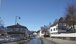
Treungen or Tveitsund is the administrative centre of Nissedal Municipality in Telemark county in Norway. Treungen and Tveitsund were previously separate villages, but they have grown together and now form one large urban area. The 1.01-square-kilometre (250-acre) village has a population (2022) of 540 and a population density of 534 inhabitants per square kilometre (1,380/sq mi). The village is the sole population centre that has more than 200 residents in all of Nissedal municipality. [1]

Contents

Local hotel Nissedal IMG 2330 Tveitsund treungen gjestgiveri.JPG
Local hotel

Treungen is surrounded by tall mountains and is situated where the river Nidelva begins at the southernmost part of the lake Nisser, Telemark's largest lake. [3] Immediately south of Treungen is the lake Tjørull, Nissedal's second-largest lake. [4] Rivers in the Treungen area include Fyresåna and Nisseråna, which both intersect to the south of the village. [5]

The Old Norse name for Treungen was «Þriðjungrinn», meaning "a third part" and probably refers to an old division of the village.

The local hotel is a building that is characteristic of Treungen's early days as a travel interchange between road and railway. The hotel is built in the Jugendstil architectural style, adorned with classical columns.

Location

Treungen Church was consecrated on March 25, 1863. Its altarpiece dates to 1751. Treungen kirke.JPG
Treungen Church was consecrated on March 25, 1863. Its altarpiece dates to 1751.

Treungen lies beside the southern end of lake Nisser, about 18 kilometres (11 mi) south of the village of Kyrkjebygda and about 20 kilometres (12 mi) to the northwest of the village of Felle. The Telemarksveien (Norwegian National Road 41) passes through the village northwards towards Vrådal and southwards towards Åmli in Agder county. The state highway was widened after the Treungen railway was dismantled in 1967. Treungen was the railway terminus. Telemark Bilruter runs a bus route between Arendal and Seljord, and this route replaces the abandoned rail connection to Arendal. Treungen is split into two by lake Nisser and in the middle of the village is Tveitsund bridge, a fine stone bridge adorned with concrete columns. The bridge was protected as a cultural monument in 1999. It is small, and traffic is controlled by lights. Throughout its history, Treungen has been closely linked with the town of Arendal and Aust-Agder county because lake Nisser was a part of the Arendal waterway and had its outflow through Nidelva. When timber was floated downriver, Treungen was an important hub. The timber came here along lake Nisser before being sent on its journey to Arendal.

Climate

Treungen has a warm-summer humid continental climate (Köppen: Dfb), [7] with cold winters and mild summers.

Climate data for Treungen (1991–2020)
MonthJanFebMarAprMayJunJulAugSepOctNovDecYear
Mean daily maximum °C (°F)1.3
(34.3)
1.8
(35.2)
5.4
(41.7)
10.1
(50.2)
15.5
(59.9)
19.5
(67.1)
21.7
(71.1)
20.3
(68.5)
15.7
(60.3)
9.6
(49.3)
4.8
(40.6)
1.9
(35.4)
10.7
(51.3)
Daily mean °C (°F)−2.0
(28.4)
−2.1
(28.2)
0.5
(32.9)
4.6
(40.3)
9.5
(49.1)
13.6
(56.5)
15.9
(60.6)
14.7
(58.5)
11.0
(51.8)
5.9
(42.6)
1.9
(35.4)
−1.1
(30.0)
6.0
(42.8)
Mean daily minimum °C (°F)−4.9
(23.2)
−5.3
(22.5)
−3.5
(25.7)
0.1
(32.2)
4.0
(39.2)
8.1
(46.6)
10.8
(51.4)
10.2
(50.4)
7.2
(45.0)
2.8
(37.0)
−0.6
(30.9)
−3.9
(25.0)
2.1
(35.8)
Average precipitation mm (inches)89.1
(3.51)
56.7
(2.23)
50.3
(1.98)
49.5
(1.95)
72.4
(2.85)
79.1
(3.11)
93.7
(3.69)
110.0
(4.33)
99.0
(3.90)
114.1
(4.49)
107.7
(4.24)
85.8
(3.38)
1,007.4
(39.66)
Average precipitation days (≥ 1.0 mm)131099910111111121312130
Source: NOAA [8]

Recreation

The mountain Skuggenatten is a Treungen landmark. Nissedal IMG 2067 rv41 Skuggenatten 706m Skardknatten 461m.JPG
The mountain Skuggenatten is a Treungen landmark.

Treungen and surrounding Nissedal are home to a variety of hiking trails, including Havrefjelløypa and Heigeitilløypa, two trails connecting Nissedal with neighboring Gautefall. Various nearby mountain peaks offer hiking trails, including Hægefjell, Skornetten, and Skuggenatten. The trailhead for Skuggenatten (western peak of Baremslandsfjell [9] ) is located by Treungen sports arena, around 1 kilometre (0.62 mi) south of Treungen village center. Its peak at 706 metres (2,316 ft) above sea-level has panoramic views of surrounding areas including the village and adjacent lake Nisser. [10] [11] [12] Skuggenatten has been called the symbol of Treungen and is located near the village center. A cabin, cairn, and a mast can be found on top. The trailhead is situated on the opposite side of the road from Treungen Fire Station. [9] Skuggenatten is the most popular mountain for hiking in the Treungen area. The trails here are also the best-marked hiking trails in Nissedal. [13]

The trailhead for Skornetten, the highest point in Kyrkjebygdheia at 883 metres (2,897 ft) above sea-level, is situated by the seter at Espeli on the eastern side of Holmevatn and Breilivatn. From the trail are panoramic views of Breilivatn, Sylvtjønn, Breili, Holmevatn, Nordbygda, Tørdal, Gautefallheia, and more. From the peak are views of Fyresdal, Vrådal, Kviteseid, Seljord, Hesthomvarden, Hjasufsknatten, and as far as Risør and the ocean outside Kragerø. [14] [15]

A number of trailheads can be found by Bjønntjønn ("Bear Lake") in Bjønntjønndalen ("Bear Valley"), including trails to Reinsvassnuten, Øverlandsvatnet, Gautefall Tourist Hotel, Heimdalsheia, and a lavvo at Breivassåsen by the lake Østre Breivatn. Several trailheads by Bjønntjønn can be found by the dam, Bjønntjønndammen, a floating dam which was constructed by Sveinung Solli in 1900. The dam was in use until the 1960s and was restored by Gautefall Turlag in 2010. [16] Various cross-country skiing trails were established near Bjønntjønn in 2008, including skiing trails to Gautefall Tourist Hotel and Bleka at Gautefallheia. [17]

The trail to the peak at Reinvassnuten lies by Reinsvatn Lake where the oldest cabin at Gautefall can be found (Reinsvasshytta). Reinsvasshytta cabin was constructed by Amboritius Olsen Lindvig in 1900. Although the main trailhead for Reinsvassnuten is located at Gautefall Tourist Hotel, there are trailheads at Bleka in Gautefall as well as near the lakes Feletjønn and Bjønntjønn in Nissedal. [18]

Lake Tjørull is located 10 kilometres (6.2 mi) south of Tjønnefoss in Treungen. The lake is home to a variety of islands and bays and is situated next to tall mountain peaks. It is used for a number of recreational activities such as canoeing, kayaking, fishing, swimming, rowing, and more. Wildlife such as eagles and beavers can often be seen by Tjørull. [19]

Notable people

Related Research Articles

<span class="mw-page-title-main">Telemark</span> Traditional region and former county (fylke) of Norway

Telemark is a county and a current electoral district in Norway. Telemark borders the counties of Vestfold, Buskerud, Vestland, Rogaland and Agder. In 2020, Telemark merged with the county of Vestfold to form the county of Vestfold og Telemark. On 1 January 2024, the county of Telemark was re-established after Vestfold og Telemark was divided again.

<span class="mw-page-title-main">Fyresdal</span> Municipality in Telemark, Norway

Fyresdal is a municipality in Telemark county, Norway. It is located in the traditional district of Vest-Telemark. The administrative centre of the municipality is the village of Moland. Other villages in Fyresdal include Kilegrend, Øvre Birtedalen, and Øyane.

<span class="mw-page-title-main">Nissedal</span> Municipality in Telemark, Norway

Nissedal is a rural municipality in Telemark region of Telemark county, Norway. It is part of the traditional regions of Upper Telemark and Vest-Telemark. The administrative centre of the municipality is the village of Treungen. Other villages in Nissedal include Kyrkjebygda and Felle.

<span class="mw-page-title-main">Kviteseid</span> Municipality in Telemark, Norway

Kviteseid is a municipality in Telemark county, Norway. It is located in the traditional districts of Vest-Telemark and Upper Telemark. The administrative centre of the municipality is the village of Kviteseidbyen. Other villages in Kviteseid include Åsgrend, Brunkeberg, Eidstod, Fjågesund, Kilen, Morgedal, and Vrådal.

<span class="mw-page-title-main">Gjerstad</span> Municipality in Agder, Norway

Gjerstad is a municipality in Agder county, Norway. It is located in the traditional region of Sørlandet, in the southeastern part of the county, along the border with Telemark county. The administrative centre of the municipality is the village of Gjerstad. Other villages in the municipality include Ausland, Eikeland, Fiane, Gryting, Østerholt, Rød, Sundebru, and Vestøl.

<span class="mw-page-title-main">Åmli</span> Municipality in Agder, Norway

Åmli is a municipality in Agder county, Norway. It is located in the traditional region of Sørlandet. The main population centre and administrative center is the village of Åmli which lies along the river Nidelva. Other villages in Åmli include Askland, Dølemo, Eppeland, Flaten, Hillestad, Homdrom, Lauveik, Nelaug, Øvre Ramse, Skjeggedal, Tveit, Vehus, and Ytre Ramse.

<span class="mw-page-title-main">Bygland</span> Municipality in Agder, Norway

Bygland is a municipality in Agder county, Norway. It is located in the traditional district of Setesdal. The administrative centre of the municipality is the village of Bygland. Other villages in the municipality include Åraksbø, Austad, Byglandsfjord, Grendi, Langeid, Lauvdal, Litveit, Longerak, Moi, Ose, Sandnes, Skåmedal, and Tveit. The Norwegian National Road 9 runs through the municipality, following the river Otra where most of the population of Bygland lives.

<span class="mw-page-title-main">Valle, Norway</span> Municipality in Agder, Norway

Valle is a municipality in Agder county, Norway. It is located in the traditional district of Setesdal. The administrative centre of the municipality is the village of Valle. Other villages in Valle include Besteland, Brokke, Homme, Hovet, Rygnestad, Rysstad, and Uppstad.

<span class="mw-page-title-main">Arendal Line</span>

The Arendal Line is a 45-kilometer (28 mi) long railway line between Arendal and Simonstad in Norway. At Nelaug, 37 kilometers (23 mi) north of Arendal, the line intersects with the Sørland Line. The southern section is electrified and provides a feeder passenger service. The line originally ran 90 kilometers (56 mi) north from Arendal to Treungen and the lake Nisser, but the upper-most part has been removed. The line is owned by the Bane NOR and operated by Go-Ahead Norge using Class 69 trains.

<span class="mw-page-title-main">Nidelva (Agder)</span> River in Telemark, Norway

Nidelva is the main river in the Arendal drainage basin in Agder county, Norway. The 221.7-kilometre (137.8 mi) long river begins at the confluence of two rivers: Nisserelva and Fyreselv. The confluence is located by the village of Haugsjåsund in Nissedal municipality in southern Telemark county. The river flows south into the Skagerrak at the city of Arendal. The watershed covers 4,011 square kilometres (1,549 sq mi) and has an average waterflow of 114.4 cubic metres per second (4,040 cu ft/s) at Rykene near the mouth. The highest waterflow ever recorded on the river was 1,200 cubic metres per second (42,000 cu ft/s) in the autumn of 1987.

<span class="mw-page-title-main">Nisser</span> Lake in Telemark, Norway

Nisser is a lake in Telemark county, Norway. It is located in Nissedal and Kviteseid municipalities, and is Telemark's largest lake. The lake is the 10th-largest lake in the nation by area with a surface area of 76.07 km2 (29.37 sq mi). The 8th largest by volume at 7.074 km3 (1.697 cu mi). The 16th deepest at 234 m (768 ft). Nisser has the greatest average depth of the norwegian lakes; who isn't a cryptodepression. It's whole lakebasin is over the sealevel. As part of the Arendal watershed, water enters this lake from the discharge from the nearby lake Vråvatn, and its outlet is the Nisserelva river which later becomes part of the river Nidelva.

<span class="mw-page-title-main">Gautefall</span> Village in Drangedal, Norway

Gautefall is a mountain village in Drangedal Municipality in Telemark county, Norway. The village is located in the mountains about 12 kilometres (7.5 mi) southwest of the village of Bustrak and about 15 kilometres (9.3 mi) northeast of the village of Treungen. Gautefall is home to a ski center and tourist resort. The village area consists mostly of vacation homes and cabins. It is located in a mountainous area and is a major winter sports destination. It is a popular destination for skiing, hiking, fishing, hunting, swimming, and other recreational activities.

Arnt Jacobsen Mørland was a Norwegian ship-owner, resistance member, and politician for the Christian Democratic Party.

<span class="mw-page-title-main">Norwegian National Road 41</span> Road in Norway

Norwegian National Road 41 is a Norwegian national road that runs through Telemark and Agder counties in Norway. The road runs between the village of Brunkeberg in Kviteseid municipality in Vestfold og Telemark county in the north and Timenes in Hånes in the city of Kristiansand in Agder county in the south. The 172.9-kilometre (107.4 mi) long road connects to the European route E134 highway in the north and to the European route E18 highway in the south. The road runs for 101.5 kilometres (63.1 mi) in Agder county and 71.4 kilometres (44.4 mi) in Vestfold og Telemark county. The southern half of the road runs along the river Tovdalselva and the lake Herefossfjorden, and it is located in a fault zone called the Kristiansand-Porsgrunn grabenen.

<span class="mw-page-title-main">Tromøy Church</span> Church in Agder, Norway

Tromøy Church is a parish church of the Church of Norway in Arendal Municipality in Agder county, Norway. It is located in the village of Brekka on the east coast of the island of Tromøy. It is one of the churches for the Tromøy parish which is part of the Arendal prosti (deanery) in the Diocese of Agder og Telemark. The white, stone church was built around the year 1150 using plans drawn up by an unknown architect. The church seats about 290 people. This was the main church for the municipality of Tromøy from 1878 until its dissolution in 1992.

<span class="mw-page-title-main">Gjøvdal Church</span> Church in Agder, Norway

Gjøvdal Church is a parish church of the Church of Norway in Åmli Municipality in Agder county, Norway. It is located in the village of Askland in the Gjøvdal valley. It is the church for the Gjøvdal parish which is part of the Aust-Nedenes prosti (deanery) in the Diocese of Agder og Telemark. The white, wooden church was built in a long church design in 1803 using plans drawn up by the architect Gjermund Gunnarson Veum. The church seats about 200 people.

<span class="mw-page-title-main">Søndeled Church</span> Church in Agder, Norway

Søndeled Church is a parish church of the Church of Norway in Risør Municipality in Agder county, Norway. It is located in the village of Søndeled. It is the church for the Søndeled parish which is part of the Aust-Nedenes prosti (deanery) in the Diocese of Agder og Telemark. The white, stone and wood church was built in a cruciform design around the year 1150 using plans drawn up by an unknown architect. The church seats about 450 people.

<span class="mw-page-title-main">Nissedal Church</span> Church in Telemark, Norway

Nissedal Church is a parish church of the Church of Norway in Nissedal Municipality in Vestfold og Telemark county, Norway. It is located in the village of Kyrkjebygda, on the east shore of the lake Nisser. It is one of the churches for the Nissedal parish which is part of the Øvre Telemark prosti (deanery) in the Diocese of Agder og Telemark. The white, wooden church was built in a cruciform design in 1764 using plans drawn up by an unknown architect. The church seats about 270 people.

<span class="mw-page-title-main">Treungen Church</span> Church in Telemark, Norway

Treungen Church is a parish church of the Church of Norway in Nissedal Municipality in Vestfold og Telemark county, Norway. It is located in the village of Treungen. It is one of the churches for the Nissedal parish which is part of the Øvre Telemark prosti (deanery) in the Diocese of Agder og Telemark. The white, wooden church was built in a long church design in 1863 using plans drawn up by the architect Peter Høier Holtermann. The church seats about 250 people.

References

  1. 1 2 3 Statistisk sentralbyrå (1 January 2022). "Urban settlements. Population and area, by municipality".
  2. "Treungen, Nissedal". yr.no . Retrieved 8 August 2023.
  3. Berg, Øivind (2016). Fra hav til hei - 123 turer i Aust-Agder, Nissedal og Fyresdal (in Norwegian). Aust-Agder Turistforening. p. 182. ISBN   9788299887014.
  4. Tveit, Olav Jakob (2017). Nisser - med bygdene rundt - Vrådal, Nissedal, Treungen (in Norwegian). Bokbyen Forlag. pp. 163 and 224. ISBN   9788283160505.
  5. Tveit, Olav Jakob (2017). Nisser - med bygdene rundt - Vrådal, Nissedal, Treungen (in Norwegian). Bokbyen Forlag. p. 232. ISBN   9788283160505.
  6. Tveit, Olav Jakob (2017). Nisser - med bygdene rundt - Vrådal, Nissedal, Treungen (in Norwegian). Bokbyen Forlag. p. 195. ISBN   9788283160505.
  7. "Table 1 Overview of the Köppen-Geiger climate classes including the defining criteria". Nature: Scientific Data.
  8. "World Meteorological Organization Climate Normals for 1991-2020 — Treungen". National Oceanic and Atmospheric Administration. Retrieved 11 January 2024.
  9. 1 2 3 Berg, Øivind (2016). Fra hav til hei - 123 turer i Aust-Agder, Nissedal og Fyresdal (in Norwegian). Aust-Agder Turistforening. pp. 200–201. ISBN   9788299887014.
  10. "Mountain Skuggenatten - Hiking in Treungen, Nissedal".
  11. "Mountain Skuggenatten".
  12. "Skuggenatten i Nissedal kommune".
  13. Tveit, Olav Jakob (2017). Nisser - med bygdene rundt - Vrådal, Nissedal, Treungen (in Norwegian). Bokbyen Forlag. p. 186. ISBN   9788283160505.
  14. Haugene, Kjell Peder (2014). 40 turer i Drangedal og Gautefall (in Norwegian). Sento Forlag AS. pp. 146–150. ISBN   9788299960502.
  15. Tveit, Olav Jakob (2017). Nisser - med bygdene rundt - Vrådal, Nissedal, Treungen (in Norwegian). Bokbyen Forlag. pp. 110 and 192. ISBN   9788283160505.
  16. Haugene, Kjell Peder (2014). 40 turer i Drangedal og Gautefall (in Norwegian). Sento Forlag AS. pp. 184–187. ISBN   9788299960502.
  17. Tveit, Olav Jakob (2017). Nisser - med bygdene rundt - Vrådal, Nissedal, Treungen (in Norwegian). Bokbyen Forlag. pp. 209–210. ISBN   9788283160505.
  18. Haugene, Kjell Peder (2014). 40 turer i Drangedal og Gautefall (in Norwegian). Sento Forlag AS. pp. 170–174. ISBN   9788299960502.
  19. Berg, Øivind (2016). Fra hav til hei - 123 turer i Aust-Agder, Nissedal og Fyresdal (in Norwegian). Aust-Agder Turistforening. pp. 198–199. ISBN   9788299887014.