Haute-Loire

Last updated • 6 min readFrom Wikipedia, The Free Encyclopedia

Haute-Loire
Naut Léger (Occitan)
Mont Mezenc03 2016-05-20.jpg
00 1130 Le Puy-en-Velay - Frankreich.jpg
F08.Brioude.0049.jpg
From top to bottom, left to right: Mont Mézenc, prefecture building in Le Puy-en-Velay, and St Julien Basilica in Brioude
Drapeau departement fr Haute-Loire.svg
Blason departement fr Haute-Loire.svg
Haute-Loire-Position.svg
Location of Haute-Loire in France
Coordinates: 45°0′N4°0′E / 45.000°N 4.000°E / 45.000; 4.000
CountryFrance
Region Auvergne-Rhône-Alpes
Prefecture Le Puy-en-Velay
Subprefectures Brioude
Yssingeaux
Government
   President of the Departmental Council Marie-Agnès Petit [1] (LR)
Area
1
  Total
4,977 km2 (1,922 sq mi)
Population
 (2021) [2]
  Total
227,284
  Rank 87th
  Density46/km2 (120/sq mi)
Time zone UTC+1 (CET)
  Summer (DST) UTC+2 (CEST)
Department number 43
Arrondissements 3
Cantons 19
Communes 257
^1 French Land Register data, which exclude estuaries and lakes, ponds and glaciers larger than 1 km2

Haute-Loire (French pronunciation: [otlwaʁ] ; Occitan : Naut Léger or Naut Leir; English: Upper Loire) is a landlocked department in the Auvergne-Rhône-Alpes region of south-central France. Named after the Loire River, it is surrounded by the departments of Loire, Ardèche, Lozère, Cantal and Puy-de-Dôme. In 2019, it had a population of 227,570; [3] its inhabitants are called Altiligériens in French (English : Altiligerians).

Contents

The department, which has its prefecture in Le Puy-en-Velay, covers the upper reaches of the Loire and consists of the Loire Valley and the surrounding mountains in the Massif Central. It is one of the original 83 departments of France created in 1790 during the French Revolution. Parts of the department are included in the Livradois-Forez Regional Natural Park.

History

The first known inhabitants of this region were hunter-gatherers and it was later occupied by pastoralists, shepherds living in caves or simple huts. It later came under the control of a Gaulish tribe called Vellavi and at the time of Julius Caesar's Gallic Wars, this area lay on the border of Gallia Narbonensis. The area became a Roman province in 121 BC, [4] originally under the name Gallia Transalpina (Transalpine Gaul). The name distinguished it from Cisalpine Gaul on the near side of the Alps to Rome. In 40 BC, during the Second Triumvirate, Lepidus was given responsibility for Narbonese Gaul (along with Hispania and Africa), while Mark Antony was given the balance of Gaul. [5]

The area was ravaged by barbarian invasions in the last years of the Roman Empire, and Galla Narbonensis and surrounding areas were incorporated into the Visigothic Kingdom between 462 and 477 AD, permanently ending the political control of Rome. After the Gothic takeover, the Visigothic dominions were generally known as Septimania. The king of the Visigoths, Alaric I was killed at the Battle of Vouillé in 507, a battle won by Clovis I and Velay came under Frankish rule. On Clovis' death in 511, his kingdom was divided among his four sons, and Velay was included in the part of the king of Austrasia, then part of the French kingdom. These subdivisions were united under the auspices of his longest surviving son Chlothar I, only to be split again under his four sons at his death. It was reunited once more under Chlothar II who became the sole ruler of the Frankish people in 613. [6]

In about 928, the area became a fiefdom of the Count of Toulouse, and later came under the control of the Count of Poitiers. In 1137, Eleanor of Aquitaine succeeded to the Duchy of Aquitaine and her marriage to Henry, Duke of Normandy, who later became Henry II of England, brought Auvergne under English rule. By the end of the thirteenth century the area was known as the Dauphiné d’Auvergne. [7]

Haute-Loire is one of the original 83 departments created during the French Revolution on 4 March 1790, by order of the National Constituent Assembly. The new departments were to be uniformly administered and approximately equal to one another in size and population. Haute-Loire was formed from parts of the former provinces of Auvergne, Languedoc, and Lyonnais. [8] Two thirds of the department, centred on Le Puy-en-Velay, used to be part of the former province of Languedoc and is known as Velay. The geographical distance from Toulouse had allowed this region to enjoy a great deal of autonomy.

During the Second World War, French partisans aided by Allied supply drops and leaders were able to liberate the province from Germans. By mid-August 1944 five weeks after the invasion at Normandy, Le Puy-en-Velay was besieged. Roads, railroad and telephone lines were cut. On 18 August, the Germans attempted to escape in a fifty-truck convoy. Five hundred were captured, and about 150 killed in a massive ambush. The town fell the next day. Estivareilles in nearby Loire fell on 22 August. Paris was captured by conventional forces on 24 August. [9]

Geography

Haute-Loire is a department in south central France and is part of the region of Auvergne-Rhône-Alpes. The capital and largest town in the department is Le Puy-en-Velay. To the north of Haute-Loire lie Puy-de-Dôme and Loire, to the east lies Ardèche, to the south lies Lozère and to the west lies Cantal. The river Loire rises in the southern part of the department and flows northwards, creating a wide valley. On either side of this lie ranges of mountains in the Massif Central. [10] The north part of the department is part of the Livradois-Forez Regional Natural Park, a protected area of traditionally-farmed agricultural land and woodland, covering a total area of 297,000 hectares (730,000 acres). [11]

The department has four mountain ranges running north and south. These are the Haut-Vivarais and its continuation, the Boutières range, the Massif du Meygal, the Velay mountains and the Margeride Mountains. [12]

The highest point of the department is the Mont Mézenc (1753 m) and its average elevation is 719 m. [13] The two-thirds of the area is over 800 m and the lowest point is 393 m.

Historically, Velay has been associated with the traditional region of Vivarais, now part of Ardèche. The two regions share a common dialect which is similar to that spoken in the south of Dauphiné, the reason probably being associated with the trade links between the two regions. [14]

Demographics

Historical population
YearPop.±% p.a.
1801229,773    
1821276,830+0.94%
1831292,078+0.54%
1841298,137+0.21%
1851304,615+0.22%
1861305,521+0.03%
1872308,732+0.10%
1881316,461+0.28%
1891316,735+0.01%
1901314,058−0.08%
1911303,838−0.33%
1921268,910−1.21%
1931251,608−0.66%
YearPop.±% p.a.
1936245,271−0.51%
1946228,076−0.72%
1954215,577−0.70%
1962211,036−0.27%
1968208,337−0.21%
1975205,491−0.20%
1982205,895+0.03%
1990206,568+0.04%
1999209,113+0.14%
2006219,484+0.69%
2011224,907+0.49%
2016227,339+0.22%
Sources: [15] [16]

Principal towns

The most populous commune is Le Puy-en-Velay, the prefecture. As of 2019, there are 6 communes with more than 5,000 inhabitants: [3]

CommunePopulation (2019)
Le Puy-en-Velay 19,215
Monistrol-sur-Loire 8,875
Yssingeaux 7,278
Brioude 6,609
Aurec-sur-Loire 6,142
Sainte-Sigolène 5,989

Politics

The president of the Departmental Council is Marie-Agnès Petit, elected in July 2021.

Current National Assembly Representatives

ConstituencyMember [17] Party
Haute-Loire's 1st constituency Isabelle Valentin The Republicans
Haute-Loire's 2nd constituency Jean-Pierre Vigier The Republicans

Notable people

Claude-Jean Allouez (1622–1689) was born in Saint-Didier-en-Velay. He was a Jesuit missionary and explorer in North America who is said to have converted ten thousand Native Americans. [18] The town of Allouez, Wisconsin is named after him. [19] The de Polignac family has its historic seat in the department, and various descendants of General Lafayette were senators for this region in the nineteenth century. The black metal band Peste Noire comes from the city La Chaise-Dieu. The Château de Chavaniac, located in the commune, was the birthplace of Gilbert du Motier, Marquis de Lafayette in 1757. Originally named Chavaniac, the commune was renamed Chavaniac-Lafayette in 1884 in honor of its most famous resident.

Tourism

The department has attractive landscapes and is popular with tourists. [7] Le Puy-en-Velay has a historic cathedral at which pilgrims gather before starting their journey to Santiago de Compostela. The cathedral has been a UNESCO World Heritage Site since 1998, as part of the "Routes of Santiago de Compostela in France". Another site of pilgrimage is at Saint Michel d'Aiguilhe, a twelfth century chapel on top of a rocky pinnacle approached by a flight of 268 steps. [20]

See also

Related Research Articles

<span class="mw-page-title-main">Loire (department)</span> Department in Auvergne-Rhône-Alpes, France

Loire is a landlocked département in the Auvergne-Rhône-Alpes region of France occupying the river Loire's upper reaches. Its prefecture is Saint-Étienne. It had a population of 765,634 in 2019.

<span class="mw-page-title-main">Puy-de-Dôme</span> Department in Auvergne-Rhône-Alpes, France

Puy-de-Dôme is a department in the Auvergne-Rhône-Alpes region in the centre of France. In 2021, it had a population of 662,285. Its prefecture is Clermont-Ferrand and subprefectures are Ambert, Issoire, Riom, and Thiers.

<span class="mw-page-title-main">Ardèche</span> Department in Auvergne-Rhône-Alpes, France

Ardèche is a department in Auvergne-Rhône-Alpes, Southeastern France. It is named after the river Ardèche and had a population of 328,278 as of 2019. Its prefecture is in Privas, but its largest city is Annonay.

<span class="mw-page-title-main">Massif Central</span> Highland region in southern France

The Massif Central is a highland region in south-central France consisting of mountains and plateaus. It covers about 15% of mainland France.

<span class="mw-page-title-main">Auvergne</span> Cultural region in France

Auvergne is a cultural region in central France.

<span class="mw-page-title-main">Arrondissement of Brioude</span> Arrondissement in Auvergne-Rhône-Alpes, France

The Arrondissement of Brioude is an arrondissement of France in the Haute-Loire department in the Auvergne-Rhône-Alpes region. It has 111 communes. Its population is 44,829 (2021), and its area is 1,886.8 km2 (728.5 sq mi).

<span class="mw-page-title-main">Arrondissement of Le Puy-en-Velay</span> Arrondissement in Auvergne-Rhône-Alpes, France

The arrondissement of Le Puy-en-Velay is an arrondissement of France in the Haute-Loire department in the Auvergne-Rhône-Alpes region. It has 102 communes. Its population is 96,495 (2021), and its area is 1,930.7 km2 (745.4 sq mi).

<span class="mw-page-title-main">Velay</span> Historical area of France

Velay is a historical area of France situated in the east Haute-Loire département and southeast of Massif Central.

Le Béage is a commune in the Ardèche department in the Auvergne-Rhône-Alpes region of southern France.

<span class="mw-page-title-main">Lavillatte</span> Commune in Auvergne-Rhône-Alpes, France

Lavillatte is a commune in the Ardèche department in southern France. It is in the Auvergne-Rhône-Alpes region.

<span class="mw-page-title-main">Saint-Sauveur-en-Rue</span> Commune in Auvergne-Rhône-Alpes, France

Saint-Sauveur-en-Rue is a commune in the Loire department in central France.

<span class="mw-page-title-main">Verveine du Velay</span> Range of liqueurs

Verveine du Velay is a range of liqueurs created in Le-Puy-en-Velay by the distillery Pagès Védrenne. Their flavour derives from lemon verbena in a melange of thirty-two plants, spices, and aromatic herbs. They are made by macerating these botanicals to form a strongly flavoured green liquor and mixing it with distillate, which is then aged in oak casks.

Communauté d'agglomération du Puy-en-Velay is the communauté d'agglomération, an intercommunal structure, centred on the town of Le Puy-en-Velay. It is located in the Haute-Loire department, in the Auvergne-Rhône-Alpes region, south-central France. Created in 2017, its seat is in Le Puy-en-Velay. Its area is 1324.0 km2. Its population was 82,871 in 2019, of which 19,215 in Le Puy-en-Velay proper.

<span class="mw-page-title-main">Auvergne (administrative region)</span> Region of France

Auvergne is a former administrative region in central France, comprising the four departments of Allier, Puy-de-Dôme, Cantal and Haute-Loire. On 1 January 2016, the region was dissolved and its territory has been part of the new region Auvergne-Rhône-Alpes.

<span class="mw-page-title-main">Mountains of Mezenc</span> Mountain range in France

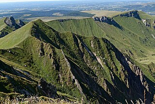
The Mont Mézenc is a mountain range in the Massif Central, bordering the departments of Ardèche and Haute-Loire, making up a natural region of France. Its highest point is Mount Mézenc, whose two summits, South and North, are respectively the highest in Ardèche at 1,753 meters and Haute-Loire at 1,744 meters.

<span class="mw-page-title-main">Velay mountains</span> Mountain range in France

The Velay mountains are the mountain ranges located in the former French province of Velay. They are situated in the eastern two-thirds of the Haute-Loire department, in the southern part of the Auvergne-Rhône-Alpes region, and in the east-central part of the Massif Central.

<span class="mw-page-title-main">Forez mountains</span> French mountain region

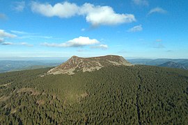
The Forez mountains are a mountain range in the Massif Central separating the Dore valley from the Forez plain. They reach their highest point at Pierre-sur-Haute, with an altitude of 1,631 meters.

<span class="mw-page-title-main">Livradois</span> French mountain region

The Livradois is a natural region in France located in the center of the Massif Central, within the departments of Puy-de-Dôme and Haute-Loire. It consists of a mountainous massif, the Livradois mountains, and a plain, the Livradois plain. Together, they form a coherent and recognized human, cultural, and economic entity, though they do not constitute a specific political entity. The Livradois is part of the Livradois-Forez Regional Natural Park.

<span class="mw-page-title-main">Brivadois</span> Natural region in France

Brivadois is a natural region of France and a traditional country of Auvergne located to the west of the department of Haute-Loire and in a small part of Puy-de-Dôme and Cantal.

<span class="mw-page-title-main">Chalmazel Ski Resort</span> Winter sports resort in the Massif Central commune of Chalmazel-Jeansagnière

Chalmazel or Chalmazel – Pierre-sur-Haute is a winter sports resort located in the Massif Central, within the commune of Chalmazel-Jeansagnière in the Loire department of the Auvergne-Rhône-Alpes region. Its alpine ski area stretches from 1,109 to 1,600 meters above sea level on the slopes of Pierre-sur-Haute, the highest point of the Monts du Forez, between the forest and the wild high moors.

References

  1. "Répertoire national des élus: les conseillers départementaux". data.gouv.fr, Plateforme ouverte des données publiques françaises (in French). 4 May 2022.
  2. "Téléchargement du fichier d'ensemble des populations légales en 2021" (in French). The National Institute of Statistics and Economic Studies. 28 December 2023.
  3. 1 2 Populations légales 2019: 43 Haute-Loire, INSEE
  4. Maddison, Angus (2007). Contours of the World Economy 1–2030 AD: Essays in Macro-Economic History. Oxford University Press. ISBN   9780191647581.
  5. Boatwright et al., The Romans, From Village to Empire, p.272 ISBN   978-0-19-511876-6
  6. Lebecq, Stéphane The Frankish origins, Points / Seuil, 1990, ( Part II, Chapter 1: " Clothar II and Dagobert ( 613-639 )) p.127
  7. 1 2 Atchley, Sharon (13 July 2014). "Introduction to the Region of Auvergne". French at a Touch. Archived from the original on 15 August 2015. Retrieved 1 October 2015.
  8. Schama,Simon (1989). Citizens: A Chronicle of the French Revolution. New York: Knopf.
  9. Purnell, Sonia (9 April 2019). A Woman of No Importance (Kindle ed.). Viking. p. 253.
  10. Philips' Modern School Atlas. George Philip and Son, Ltd. 1973. pp. 42–43. ISBN   0-540-05278-7.
  11. IUCN Commission on National Parks and Protected Areas (November 1990). 1990 United Nations list of national parks and protected areas. IUCN. p. 89. ISBN   978-2-8317-0032-8 . Retrieved 27 September 2015.
  12. Bozman, E.F. (1966). Everyman's Encyclopaedia: Volume 8. J.M. Dent and Sons. p. 29.
  13. "Haute-Loire : La montagne attire-t-elle encore du monde ?".
  14. Clout, Hugh D. (2013). Themes in the Historical Geography of France. Elsevier. pp. 61–62. ISBN   978-1-4832-6724-1.
  15. "Historique de la Haute-Loire". Le SPLAF.
  16. "Évolution et structure de la population en 2016". INSEE.
  17. Nationale, Assemblée. "Assemblée nationale ~ Les députés, le vote de la loi, le Parlement français". Assemblée nationale.
  18. "Allouez, Claude Jean (1622-1689)". Wisconsin Historical Society. Retrieved 1 October 2015.
  19. Chicago and North Western Railway Company (1908). A History of the Origin of the Place Names Connected with the Chicago & North Western and Chicago, St. Paul, Minneapolis & Omaha Railways. p. 166.
  20. "St. Michel d'Aiguilhe, Le Puy". Sacred destinations. Retrieved 1 October 2015.