Loire is a landlocked département in the Auvergne-Rhône-Alpes region of France occupying the river Loire's upper reaches. Its prefecture is Saint-Étienne. It had a population of 765,634 in 2019.

Nord is a département in Hauts-de-France region, France bordering Belgium. It was created from the western halves of the historical counties of Flanders and Hainaut, and the Bishopric of Cambrai. The modern coat of arms was inherited from the County of Flanders.

Calvados is a department in the Normandy region in northwestern France. It takes its name from a cluster of rocks off the Normandy coast. In 2019, it had a population of 694,905.

Seine-Maritime is a department of France in the Normandy region of northern France. It is situated on the northern coast of France, at the mouth of the Seine, and includes the cities of Rouen and Le Havre. Until 1955 it was named Seine-Inférieure. It had a population of 1,255,633 in 2019.

Marne is a department in the Grand Est region of France. It is named after the river Marne which flows through it. The prefecture (capital) of Marne is Châlons-en-Champagne. The subprefectures are Épernay, Reims, and Vitry-le-François. It had a population of 566,855 in 2019.

Haute-Marne is a department in the Grand Est region of Northeastern France. Named after the river Marne, its prefecture is Chaumont. In 2019, it had a population of 172,512.

Yvelines is a department in the western part of the Île-de-France region in Northern France. In 2019, it had a population of 1,448,207. Its prefecture is Versailles, home to the Palace of Versailles, the principal residence of the King of France from 1682 until 1789, a UNESCO World Heritage Site since 1979. Yvelines' subprefectures are Saint-Germain-en-Laye, Mantes-la-Jolie and Rambouillet.

Manche is a coastal French département in Normandy on the English Channel, which is known as La Manche, literally "the sleeve", in French. Manche is bordered by Ille-et-Vilaine and Mayenne to the south, Orne and Calvados to the east, the English Channel to the west and north and by sharing maritime borders with the Crown Dependencies of Bailiwick of Jersey and Bailiwick of Guernsey of the United Kingdom to the west. It had a population of 495,045 in 2019.

Eure is a department in Normandy in Northwestern France, named after the river Eure. Its prefecture is Évreux. In 2021, Eure had a population of 598,934.

Eure-et-Loir is a French department, named after the Eure and Loir rivers. It is located in the region of Centre-Val de Loire. In 2019, Eure-et-Loir had a population of 431,575.
Meurthe-et-Moselle is a département in the Grand Est region of France, named after the rivers Meurthe and Moselle. Its prefecture and largest city is Nancy and it borders the departments of Meuse to the west, Vosges to the south, Moselle and Bas-Rhin and it borders the Belgian province of Luxembourg and the country of Luxembourg by the canton of Esch-sur-Alzette to the north. It had a population of 733,760 in 2019.

Mayenne is a landlocked department in northwest France named after the river Mayenne. Mayenne is part of the administrative region of Pays de la Loire and is surrounded by the departments of Manche, Orne, Sarthe, Maine-et-Loire, and Ille-et-Vilaine.

Oise is a department in the north of France. It is named after the river Oise. Inhabitants of the department are called Oisiens or Isariens, after the Latin name for the river, Isara. It had a population of 829,419 in 2019.

Sarthe is a department of the French region of Pays de la Loire, and the province of Maine, situated in the Grand-Ouest of the country. It is named after the river Sarthe, which flows from east of Le Mans to just north of Angers. It had a population of 566,412 in 2019.

Essonne is a department in the southern part of the Île-de-France region in Northern France. It is named after the river Essonne. In 2019, it had a population of 1,301,659, across 194 communes.

Val-de-Marne is a department of France located in the Île-de-France region. Named after the river Marne, it is situated in the Grand Paris metropolis to the southeast of the City of Paris. In 2019, Val-de-Marne had a population of 1,407,124.

Val-d'Oise is a department in the Île-de-France region, Northern France. It was created in 1968 following the split of the Seine-et-Oise department. In 2019, Val-d'Oise had a population of 1,249,674.

Normandy is the northwesternmost of the eighteen regions of France, roughly coextensive with the historical Duchy of Normandy.

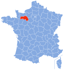
The 1st constituency of the Orne is a French legislative constituency in the Orne département. Like the other 576 French constituencies, it elects one MP using a two round electoral system.

The Communauté de communes d'Argentan Intercom is a federation of municipalities in the Orne département and in the Normandy région of France. Its seat is Argentan. Its area is 715.1 km2, and its population in 2019 was 33,409. It covers some of the Communes that make up the area known as Suisse Normande.