Major road and railway bridges
This table presents the structures greater than 1,000 meters (non-exhaustive list).
| Name | Span | Length | Type | Carries Crosses | Opened | Location | Ref. | ||
|---|---|---|---|---|---|---|---|---|---|
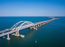 | 1 | Crimean Rail Bridge | 227 m (745 ft) | 18,118.05 m (59,442.4 ft) | Arch Steel tied-arch | 2019 | Taman – Kerch 45°18′30.8″N36°30′20.6″E / 45.308556°N 36.505722°E | [S 1] | |
 | 2 | Crimean Road Bridge | 227 m (745 ft) | 16,857.28 m (55,306.0 ft) | Arch Steel tied-arch | 2018 | Taman – Kerch 45°18′31.6″N36°30′22.5″E / 45.308778°N 36.506250°E | [S 2] | |
 | 3 | Southern overpass of the Western High-Speed Diameter | 9,378 m (30,768 ft) | 8 lanes road bridge Neva | 2016 | ||||
 | 4 | Northern overpass of the Western High-Speed Diameter | 8,794.5 m (28,853 ft) | 8 lanes road bridge Neva | 2016 | ||||
 | 5 | Tongjiang-Nizhneleninskoye railway bridge | 7,194 m (23,602 ft) | Railway bridge Amur | 2022 | ||||
 | 6 | President Bridge | 221 m (725 ft)(x25) | 5,825 m (19,111 ft) | Truss bridge Steel | 4 lanes road bridge Volga | 2009 | Ulyanovsk 54°21′39.3″N48°26′16.8″E / 54.360917°N 48.438000°E | [S 3] |
 | 7 | Moscow Monorail overpass | 4,698 m (15,413 ft) | Railway bridge | 2004 | ||||
| 8 | Lena Bridge under construction | 4,610 m (15,120 ft) | 2 lanes road bridge Lena | 2028 | |||||
 | 9 | Amur Bay Bridge | 4,364 m (14,318 ft) | 4 lanes road bridge Amur Bay | 2012 | ||||
| 10 | Yuribey Bridge | 3,893 m (12,772 ft) | Railway bridge Yuribey | 2009 | |||||
 | 11 | Khabarovsk Bridge | 3,891 m (12,766 ft) | 1916 1999 | |||||
 | 12 | Volga Bridge (Tolyatti bypass) | 3,750 m (12,300 ft) | 4 lanes road bridge Volga | 2024 | ||||
 | 13 | Jubilee Bridge | 3,510 m (11,520 ft) | 4 lanes road bridge Volga | 2010 | ||||
 | 14 | Volga Bridge (M12) | 3,362 m (11,030 ft) | 4 lanes road bridge Volga | 2023 | ||||
 | 15 | Russky Bridge | 1,104 m (3,622 ft) | 3,100 m (10,200 ft) | Cable-stayed Steel box girder deck, concrete pylons | 4 lanes road bridge Eastern Bosphorus | 2012 | Vladivostok 43°03′48.2″N131°54′27.9″E / 43.063389°N 131.907750°E | [S 4] |
 | 16 | Bolshoy Obukhovsky Bridge | 382 m (1,253 ft) | 2,824 m (9,265 ft) | Cable-stayed Steel box girder deck, steel pylons Twin bridges | 2004 2007 | Saint Petersburg 59°51′13.7″N30°29′33.5″E / 59.853806°N 30.492639°E | [S 5] | |
 | 17 | Saratov Bridge | 166 m (545 ft)(x3) | 2,804 m (9,199 ft) | Arch Concrete deck arch | 3 lanes road bridge Volga | 1965 | Saratov - Engels 51°31′19.0″N46°04′02.6″E / 51.521944°N 46.067389°E | [S 6] |
 | 18 | East Exit Bridge | 2,670 m (8,760 ft) | 4 lanes road bridge Ufa | 2024 | ||||
 | 19 | Krasnaya Polyana Railway Bridge | 2,517 m (8,258 ft) | Railway bridge | 2013 | ||||
 | 20 | Volgograd Bridge | 157 m (515 ft)(x3) | 2,514 m (8,248 ft) | Box girder Steel Twin bridges | 4 lanes road bridge Volga | 2009 | Volgograd 48°43′17.3″N44°33′02.6″E / 48.721472°N 44.550722°E | [S 7] |
| 21 | Big Sursky Bridge | 1,242 m (4,075 ft) 2,416 m (7,927 ft) | 2012 2024 | ||||||
 | 22 | New Saratov Bridge | 157 m (515 ft)(x3) | 2,351 m (7,713 ft) | Box girder Steel 10x126+3x157+3x126 Twin bridges | 4 lanes road bridge Volga | 2000 2009 | Saratov - Engels 51°35′33.7″N46°12′49.7″E / 51.592694°N 46.213806°E | [S 8] |
 | 23 | Temernitsky Bridge | 2,255 m (7,398 ft) | 6 lanes road bridge Don | 2010 | ||||
| 24 | Staromatsestinsky viaduct | 2,208 m (7,244 ft) | 2 lanes road viaduct | 2013 | |||||
 | 25 | Novosibirsk Metro Bridge | 2,145 m (7,037 ft) | Railway bridge Ob | 2013 | ||||
 | 26 | Yugra Bridge | 408 m (1,339 ft) | 2,110 m (6,920 ft) | Cable-stayed Steel box girder deck, steel pylon | 2 lanes road bridge Ob | 2000 | Surgut 61°13′03.7″N73°09′36.5″E / 61.217694°N 73.160139°E | [S 9] |
 | 27 | Bugrinsky Bridge | 380 m (1,250 ft) | 2,097 m (6,880 ft) | Arch Steel tied-arch Bow-string bridge | 6 lanes road bridge Ob | 2014 | Novosibirsk 54°58′29.8″N82°57′44.1″E / 54.974944°N 82.962250°E | [S 10] |
 | 28 | Imperial Bridge | 2,089 m (6,854 ft) | 1916 1958 | |||||
 | 29 | Yugra railway bridge | 2,010 m (6,590 ft) | Railway bridge Ob | 1975 | ||||
 | 30 | Tura Bridge | 1,965 m (6,447 ft) | 2 lanes road bridge Tura | 2008 | ||||
 | 31 | Zeya New Bridge | 1,932 m (6,339 ft) | 2 lanes road bridge Zeya | 2023 | ||||
| 32 | Don Bridge | 1,901 m (6,237 ft) | 4 lanes road bridge Don | 2023 | |||||
 | 33 | Second flyover bridge | 1,883 m (6,178 ft) | 6 lanes road bridge Pregolya | 2011 | ||||
 | 34 | Syzran Bridge | 109 m (358 ft)(x13) | 1,483 m (4,865 ft) | Truss bridge Steel | 1880 | Syzran 53°10′24.8″N48°47′49.9″E / 53.173556°N 48.797194°E | [1] | |
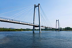
 | 35 | Zhivopisny Bridge | 409 m (1,342 ft) | 1,460 m (4,790 ft) | Cable-stayed Steel box girder deck, steel arch pylon | 2007 | Moscow 55°46′34.6″N37°26′36.0″E / 55.776278°N 37.443333°E | [S 11] | |
 | 36 | Murom Bridge | 231 m (758 ft)(x2) | 1,393 m (4,570 ft) | Cable-stayed Composite steel/concrete deck, 3 concrete pylons 108+2x231+108 | 2009 | Murom 55°37′04.3″N42°04′05.2″E / 55.617861°N 42.068111°E | [S 12] | |
 | 37 | Zolotoy Bridge | 737 m (2,418 ft) | 1,388.09 m (4,554.1 ft) | Cable-stayed Steel box girder deck, concrete pylons | 6 lanes road bridge Zolotoy Rog | 2012 | Vladivostok 43°06′32.7″N131°53′46.8″E / 43.109083°N 131.896333°E | [S 13] |
 | 38 | Irtych River Bridge | 231 m (758 ft) | 1,316 m (4,318 ft) | Arch Steel through arch | 2 lanes road bridge Irtysh | 2004 | Khanty-Mansiysk 60°59′20.3″N68°58′49.9″E / 60.988972°N 68.980528°E | [S 14] |
| 39 | Murom Highway Bridge under construction | 254 m (833 ft) | 1,300 m (4,300 ft) | Cable-stayed Composite steel/concrete deck, concrete pylons | Murom 55°37′16.1″N42°04′28.0″E / 55.621139°N 42.074444°E | [2] | |||
 | 40 | Kostroma Bridge | 148 m (486 ft) | 1,236 m (4,055 ft) | Box girder Prestressed concrete Twin bridges | 4 lanes road bridge Volga | 1972 | Kostroma 57°45′09.4″N40°56′18.4″E / 57.752611°N 40.938444°E | [S 15] |
 | 41 | Finland Railway Bridge | 100 m (330 ft)(x3) | 1,139 m (3,737 ft) | Arch Steel through arch Vertical-lift bridge | Railway bridge Neva | 1912 | Saint Petersburg 59°54′55.5″N30°24′33.4″E / 59.915417°N 30.409278°E | [S 16] |