List of bridges in Zimbabwe

Last updated

Contents

Historical and architectural interest bridges

NameDistinctionLengthTypeCarries
Crosses
OpenedLocationProvinceRef.
1 Kariba Dam Suspension Bridge
dismantled
Temporary bridge used for the construction of the Kariba Dam
Span : 424 m (1,391 ft)
219 m (719 ft) Suspension
Towerless, steel truss deck
Road bridge
Zambezi
1958 Kariba Siavonga
16°31′17.5″S28°45′45.6″E / 16.521528°S 28.762667°E / -16.521528; 28.762667 (Kariba Dam Suspension Bridge)
Mashonaland West Province
Flag of Zambia.svg  Zambia
[1]

Major bridges

NameSpanLengthTypeCarries
Crosses
OpenedLocationProvinceRef.
Bbridge.jpg 1 Birchenough Bridge 329 m (1,079 ft)378 m (1,240 ft) Arch
Steel through arch
1935 Chipinge
19°57′43.1″S32°20′39.3″E / 19.961972°S 32.344250°E / -19.961972; 32.344250 (Birchenough Bridge)
Manicaland Province [S 1]
[2]
[3]
Olto Beit Bridge over the Zambesi at Chirundu. North Rhodesia (37788904851).jpg 2 Otto Beit Bridge 328 m (1,076 ft)369 m (1,211 ft) Suspension
Steel truss deck, steel pylons
1939 Chirundu, Zimbabwe Chirundu, Zambia
16°02′16.6″S28°51′08.2″E / 16.037944°S 28.852278°E / -16.037944; 28.852278 (Otto Beit Bridge)
Mashonaland West Province
Flag of Zambia.svg  Zambia
[S 2]
[4]
[5]
The bridges at Chirundu border post.jpg 3 Second Chirundu Bridge 160 m (520 ft)400 m (1,300 ft) Box girder
Prestressed concrete
119+160+119
2002 Chirundu, Zimbabwe Chirundu, Zambia
16°02′18.8″S28°51′05.8″E / 16.038556°S 28.851611°E / -16.038556; 28.851611 (Second Chirundu Bridge)
Mashonaland West Province
Flag of Zambia.svg  Zambia
[S 3]
[6]
[7]
[8]
Victoria Falls Bridge, Zambia.jpg 4 Victoria Falls Bridge 156 m (512 ft)198 m (650 ft) Arch
Steel deck arch
1905 Victoria Falls Livingstone
17°55′42.2″S25°51′25.3″E / 17.928389°S 25.857028°E / -17.928389; 25.857028 (Victoria Falls Bridge)
Matabeleland North Province
Flag of Zambia.svg  Zambia
[S 4]
[9]
[10]

See also

Map all coordinates using: OpenStreetMap

Related Research Articles

This article is about the Transport in Zambia.

<span class="mw-page-title-main">Zambezi</span> Major river in southern Africa

The Zambezi is the fourth-longest river in Africa, the longest east-flowing river in Africa and the largest flowing into the Indian Ocean from Africa. Its drainage basin covers 1,390,000 km2 (540,000 sq mi), slightly less than half of the Nile's. The 2,574-kilometre-long (1,599 mi) river rises in Zambia and flows through eastern Angola, along the north-eastern border of Namibia and the northern border of Botswana, then along the border between Zambia and Zimbabwe to Mozambique, where it crosses the country to empty into the Indian Ocean.

<span class="mw-page-title-main">Victoria Falls</span> Waterfall on the Zambezi River in Zambia and Zimbabwe

Victoria Falls is a waterfall on the Zambezi River in southern Africa, which provides habitat for several unique species of plants and animals. It is located on the border between Zambia and Zimbabwe and is one of the world's largest waterfalls, with a width of 1,708 m (5,604 ft).

<span class="mw-page-title-main">Alfred Beit</span> German born businessman and mining magnate in South Africa

Alfred Beit was an Anglo-German gold and diamond magnate in South Africa, and a major donor and profiteer of infrastructure development on the African continent. He also donated much money to university education and research in several countries, and was the "silent partner" who structured the capital flight from post-Boer War South Africa to Rhodesia, and the Rhodes Scholarship, named after his employee, Cecil Rhodes. Beit's assets were structured around the so-called Corner House Group, which through its holdings in various companies controlled 37 per cent of the gold produced at the Witwatersrand's goldfields in Johannesburg in 1913.

<span class="mw-page-title-main">Birchenough Bridge</span> Human settlement and bridge

Birchenough Bridge is the name for both a bridge across the Save River and a village next to the bridge. Birchenough Bridge is called after Sir Henry Birchenough. Birchenough Bridge is located 62 km from Chipinge in the Manicaland province of Zimbabwe linking Chipinge with Buhera.

<span class="mw-page-title-main">Victoria Falls Bridge</span> Transnational bridge connecting Zambia and Zimbabwe

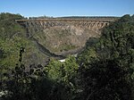
The Victoria Falls Bridge crosses the Zambezi River just below the Victoria Falls and is built over the Second Gorge of the falls. As the river forms the border between Zimbabwe and Zambia, the bridge links the two countries and has border posts on the approaches to both ends, at the towns of Victoria Falls, Zimbabwe, and Livingstone, Zambia.

<span class="mw-page-title-main">Victoria Falls, Zimbabwe</span> Place in Matabeleland North, Zimbabwe

Victoria Falls, popularly known as Vic Falls, is a resort town and city in the province of Matabeleland North, Zimbabwe. It lies on the southern bank of the Zambezi River at the western end of Victoria Falls themselves. According to the 2022 Population Census, the town had a population of 35,199.

<span class="mw-page-title-main">Chirundu, Zambia</span> Town in Southern Province, Zambia

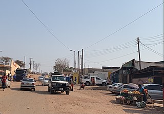
Chirundu, Zambia is a town in the Southern Province of Zambia at the border with Zimbabwe. It is the site of two road bridges across the Zambezi river, the Chirundu Bridges.

<span class="mw-page-title-main">Luangwa Bridge</span>

The Luangwa Bridge is the only large bridge and the principal engineering challenge on Zambia's Great East Road, crossing the lower Luangwa River where it flows from the Luangwa Rift Valley into the Zambezi valley.

<span class="mw-page-title-main">Chirundu Bridge</span> Bridge in Zimbabwe, crossing the Zimbabwe-Zambia border

The Chirundu Bridge now consists of two road bridges side by side across the Zambezi River between the small town of Chirundu, Zambia and the village of Chirundu, Zimbabwe. At this location around 65 km downstream from the Kariba Dam the river is about 400 m wide. The bridges were once seen as part of a Cape to Cairo Road and thus are on the Harare to Lusaka section of the route.

This article gives lists of the National Monuments and other historic sites of Zambia, with a one- or two-line description providing links to details given on other pages.

Sir Gilbert Roberts was a British civil engineer who designed many famous bridges worldwide.

<span class="mw-page-title-main">Cairo–Cape Town Highway</span> Transcontinental road network

The Cairo–Cape Town Highway is Trans-African Highway 4 in the transcontinental road network being developed by the United Nations Economic Commission for Africa (UNECA), the African Development Bank (AfDB), and the African Union. The route has a length of 10,228 km (6,355 mi) and links Cairo in Egypt to Cape Town in South Africa.

R3 Highway is a primary road in Zimbabwe from the capital city Harare to the Chirundu Border Post with Zambia. It is also known as the A1 Highway. It is part of both the Beira–Lobito Highway and the Cape to Cairo Road.

The A9 Road is a national highway in Zimbabwe running from Mutare to Mbalabala. The road begins in Mutare and runs south-west through Nyanyadzi, Birchenough Bridge, Masvingo, Mashava, Zvishavane, Filabusi and ends at Mbalabala where it joins the (A6) Bulawayo-Beit Bridge Highway near the 61.5 km peg. It has a total of just less than 513 kilometres (319 mi), which is about a 6 hours 15 minute drive.

The A8 Highway is a paved primary trunk road in Zimbabwe running from Bulawayo to Victoria Falls. It is managed by the Zimbabwe National Roads Administration (ZINARA). It is part of the R9 Route, which links Victoria Falls with Beitbridge.

References

  1. "Birchenough Bridge".
  2. "Otto Beit Bridge".
  3. "Chirundu Bridge".
  4. "Victoria Falls Bridge".
  1. Thompson, F.B. (April 1960). "The road suspension bridge at Kariba". Civil Engineering. South African Institution Of Civil Engineering (SAICE). 2 (4): 57–65. hdl:10520/AJA10212019_15943. ISSN   1021-2000.
  2. Shirley Smith, H.; Faber, O.; Bateson, E.; Freeman, R.; Henzell, J.S. (May 1945). "Discussion - The design and erection of the Birchenough and Otto Beit Bridges, Rhodesia". Journal of the Institution of Civil Engineers. 24 (7): 195–208. doi: 10.1680/ijoti.1945.12258 . ISSN   0368-2455.
  3. "The Birchenough Bridge". Wondersofworldengineering.com. Retrieved 2 December 2022.
  4. "History of the Beit Trust". Beittrust.org.uk. Retrieved 26 March 2023.
  5. "Ponte sospeso "Sir Otto Beit Bridge" (Zambia)" [Suspension bridge "Sir Otto Beit Bridge" (Zambia)]. Isg-progetti.it - ISG-progetti Ingegneria Strutturale e Geotecnica (in Italian). Retrieved 26 March 2023.
  6. Yamazaki, Keiji; Kashiwamura, Tomohiko; Otsubo, Masato; Yamazaki, Jun. "Chirundu Bridge Construction Project in Zambia/Zimbabwe". The Importance of Design and Technical Management in International Bridge (PDF). Ssms.jp. Archived from the original (PDF) on 3 January 2020.
  7. The Feasibility Study on the Proposed New Bridge Over the Zambezi River at Chirundu Border Post (PDF). Openjicareport.jica.go.jp (Report). Japan International Cooperation Agency. pp. 45–112.
  8. "Traffic Opens on the Chirundu Bridge Linking Zambia and Zimbabwe". Kajima.co.jp - Kajima Corporation . Kajima News & Notes Vol.24. 2003. Archived from the original on 3 March 2016.
  9. "Victoria Falls Bridge". Asce.org - American Society of Civil Engineers . Archived from the original on 23 April 2021.
  10. Roberts, Peter (2011). "Sun, Steel & Spray - A history of the Victoria Falls Bridge". Zambezibookcompany.com. Retrieved 2 December 2022.

Further reading