Victoria Falls Bridge

Last updated

Victoria Falls Bridge
Puente de las cataratas Victoria, Zambia-Zimbabue, 2018-07-27, DD 10.jpg
Coordinates 17°55′42″S25°51′26″E / 17.92833°S 25.85722°E / -17.92833; 25.85722
Carriesroad, rail, foot traffic
Crosses Zambezi River
LocaleSecond Gorge of Victoria Falls, crossing the Zimbabwe-Zambia border
Maintained byNational railways of Zimbabwe and Zambia [1]
Characteristics
Design Parabolic arch [2]
MaterialSteel
Total length198 metres (650 ft) [1]
Height128 metres (420 ft) [3]
Longest span156.5 metres (513 ft) [3]
No. of spans1
Piers in water0
History
DesignerG. A. Hobson [1]
Constructed by Cleveland Bridge & Engineering Company
Construction start1904 [1]
Construction end1905 [1]
Location
Victoria Falls Bridge

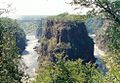
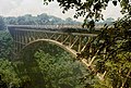
The Victoria Falls Bridge crosses the Zambezi River just below the Victoria Falls and is built over the Second Gorge of the falls. As the river forms the border between Zimbabwe and Zambia, the bridge links the two countries and has border posts on the approaches to both ends, at the towns of Victoria Falls, Zimbabwe, and Livingstone, Zambia.

Contents

History

The bridge was the brainchild of Cecil Rhodes, part of his grand and unfulfilled Cape to Cairo railway scheme, even though he never visited the falls and died before construction of the bridge began. Rhodes is recorded as instructing the engineers to "build the bridge across the Zambezi where the trains, as they pass, will catch the spray of the Falls". [4] It was designed by George Andrew Hobson of consultants Sir Douglas Fox and Partners, assisted by the stress calculations of Ralph Freeman, who was later the principal designer of the Sydney Harbour Bridge. The main central arch is a parabolic curve. [5] [6] [2] [7]

The bridge was prefabricated in England by the Cleveland Bridge & Engineering Company, [3] before being shipped to the port city of Beira in Portuguese-ruled Mozambique, and then transported on the newly constructed railway to the Victoria Falls. It took just 14 months to construct and was completed in 1905.

The bridge was officially opened by Professor Sir George Darwin, son of Charles Darwin and President of the British Association (now the British Science Association), on 12 September 1905. [8] The American Society of Civil Engineers has designated the bridge as an International Historic Civil Engineering Landmark. [1]

The bridge under construction in 1905 Victoria Falls Bridge 1905.jpg
The bridge under construction in 1905
Victoria Falls Bridge from the Knife Edge Bridge trail near the falls on the Zambia side Victoria Falls Bridge from the Knife Edge Bridge trail.jpg
Victoria Falls Bridge from the Knife Edge Bridge trail near the falls on the Zambia side

Constructed from steel, the bridge is 198 metres (650 ft) [1] long, with a main arch spanning 156.50 metres (513.5 ft), [3] at a height of 128 metres (420 ft) [3] above the lower water mark of the river in the gorge below. It carries a road, railway and footway. The bridge is the only rail link between Zambia and Zimbabwe and one of only three road links between the two countries. [9]

The Victoria Falls Bridge did not bring the first train or the first railway to Northern Rhodesia (called Zambia since 1964). To push on with construction of the railway north as fast as possible, Cecil Rhodes insisted that the Livingstone to Kalomo line be laid before the bridge was finished. Then a locomotive was conveyed in pieces across the gorge by the temporary electric cableway used for the transportation of the bridge materials and nicknamed the 'Blondin' by the construction engineers. [10] The locomotive was re-assembled and entered service months before the bridge was complete. [11]

For more than 50 years, the bridge was crossed regularly by passenger trains as part of the principal route between the then Northern Rhodesia, southern Africa and Europe. Freight trains carried mainly copper ore (later, copper ingots) and timber out of Northern Rhodesia, and coal into the country.

The age of the bridge and maintenance problems have led to traffic restrictions at times. Trains cross at less than walking pace and trucks were limited to 30 t, necessitating heavier trucks making a long diversion via the Kazungula Ferry or Chirundu Bridge. The limit was raised after repairs in 2006, [12] but proposals for more fundamental rehabilitation or construction of a new bridge have been aired. [13]

Tolls collectors were employed in 1905, but tolls were abolished 1906 [14]

During the Rhodesian UDI crisis and Bush War, the bridge was frequently closed (and regular passenger services have not resumed successfully). In 1975, the bridge was the site of unsuccessful peace talks when the parties met in a train carriage poised above the gorge for nine and a half hours. [15] In 1980, freight and road services resumed and have continued without interruption except for maintenance.

Today, one of the Victoria Falls Bridge's main attraction are historical guided tours focusing on the construction of the bridge and include a walking tour under the main deck. [16] On the Zambian side there is a small museum about the bridge which is free to enter and contains a café selling refreshments. Also located on the bridge is the Shearwater 111 metres (364 ft) bungee jump including a bungee swing and zip-line. Concerns about safety of the attraction were raised in late 2011 after the bungee's cord snapped and a young Australian woman fell 24 metres (79 ft) into the fast-flowing river (she survived). [17]

The bridge was originally referred to as the Great Zambesi or Zambezi Bridge, later becoming known as the Victoria Falls Bridge.

Map

The Location of the bridge and surrounding area by Openstreetmap

See also

Related Research Articles

<span class="mw-page-title-main">Zambezi</span> Major river in southern Africa

The Zambezi is the fourth-longest river in Africa, the longest east-flowing river in Africa and the largest flowing into the Indian Ocean from Africa. Its drainage basin covers 1,390,000 km2 (540,000 sq mi), slightly less than half of the Nile's. The 2,574 km (1,599 mi) river rises in Zambia and flows through eastern Angola, along the north-eastern border of Namibia and the northern border of Botswana, then along the border between Zambia and Zimbabwe to Mozambique, where it crosses the country to empty into the Indian Ocean.

<span class="mw-page-title-main">Victoria Falls</span> Waterfall on the Zambezi River in Zambia and Zimbabwe

Victoria Falls is a waterfall on the Zambezi River in southern Africa, which provides habitat for several unique species of plants and animals. It is located on the border between Zambia and Zimbabwe and is one of the world's largest waterfalls, with a width of 1,708 m (5,604 ft).

<span class="mw-page-title-main">Kafue</span> Town in Lusaka Province, Zambia

Kafue is a town on the T2 road in the Lusaka Province of Zambia and it lies on the north bank of the Kafue River, after which it is named. It is the southern gateway to the central Zambian plateau on which Lusaka and the mining towns of Kabwe and the Copperbelt are located.

<span class="mw-page-title-main">Livingstone, Zambia</span> Place in Southern Province, Zambia

Livingstone is a city in Zambia. Until 1935, it served as the capital of Northern Rhodesia. Lying 10 km (6 mi) to the north of the Zambezi River, it is a tourism attraction center for the Victoria Falls and a border town with road and rail connections to Zimbabwe on the other side of the Victoria Falls. A historic British colonial city, its present population was enumerated at 177,393 inhabitants at the 2022 census. It is named after David Livingstone, the Scottish explorer and missionary who was the first European to explore the area. Until 2011, Livingstone was the provincial capital of Zambia's Southern Province.

<span class="mw-page-title-main">Victoria Falls, Zimbabwe</span> Resort City in Matabeleland North, Zimbabwe

Victoria Falls, popularly known as Vic Falls, is a resort town and city in the province of Matabeleland North, Zimbabwe. It lies on the southern bank of the Zambezi River at the western end of Victoria Falls themselves. According to the 2022 Population Census, the town had a population of 35,199.

<span class="mw-page-title-main">Zambia Railways</span> National railway company of Zambia

Zambia Railways (ZR) is the national railway company of Zambia, one of the two major railway organisations in Zambia. The other system is the binational TAZARA Railway (TAZARA) that interconnects with the ZR at Kapiri Mposhi and provides a link to the Tanzanian port of Dar es Salaam.

<span class="mw-page-title-main">Mosi-oa-Tunya National Park</span> National park in Zambia

Mosi-oa-Tunya National Park is a UNESCO World Heritage Site that is home to one half of the Mosi-oa-Tunya "The Smoke that Thunders", known worldwide as Victoria Falls — on the Zambezi River. The river forms the border between Zambia and Zimbabwe, so the falls are shared by the two countries, and the park is twin to the Victoria Falls National Park on the Zimbabwean side.

<span class="mw-page-title-main">Kazungula</span> Human settlement in Zambia

Kazungula is a small border town in Zambia, lying on the north bank of the Zambezi River about 70 kilometres (45 mi) west of Livingstone on the M10 Road.

<span class="mw-page-title-main">Rail transport in Botswana</span> Rail Transport in Botswana

Rail services in Botswana are provided by Botswana Railways in Botswana. Most routes in the country radiate from Gaborone. The railway network consists of 888 km, its gauge is 1,067 mm cape gauge.

<span class="mw-page-title-main">Mulobezi Railway</span>

The Mulobezi Railway was constructed to carry timber from Mulobezi to Livingstone in the Southern Province of Zambia, when the country was Northern Rhodesia. The line uses the 1,067 mm narrow gauge, also known as 'Cape gauge', shared by all main line railways in Southern Africa.

<span class="mw-page-title-main">Chirundu Bridge</span> Bridge in Zimbabwe, crossing the Zimbabwe-Zambia border

The Chirundu Bridge now consists of two road bridges side by side across the Zambezi River between the small town of Chirundu, Zambia and the village of Chirundu, Zimbabwe. At this location around 65 km downstream from the Kariba Dam the river is about 400 m wide. The bridges were once seen as part of a Cape to Cairo Road and thus are on the Harare to Lusaka section of the route.

This article gives lists of the National Monuments and other historic sites of Zambia, with a one- or two-line description providing links to details given on other pages.

<span class="mw-page-title-main">Kazungula Ferry</span> Pontoon ferry across the Zambezi River

The Kazungula Ferry was a pontoon ferry across the 400-metre-wide (1,300 ft) Zambezi River between Botswana and Zambia. It was one of the largest ferries in south-central Africa, having a capacity of 70 tonnes. The service was provided by two motorised pontoons and operated between border posts at Kazungula, Zambia and Kazungula, Botswana.

<span class="mw-page-title-main">Outline of Zambia</span> Overview of and topical guide to Zambia

The following outline is provided as an overview of and topical guide to Zambia:

Zambia, officially known as the Republic of Zambia, is a landlocked country in Southern Africa. The neighbouring countries are the Democratic Republic of the Congo to the north, Tanzania to the north-east, Malawi to the east, Mozambique, Zimbabwe, Botswana, and Namibia to the south, and Angola to the west. The capital city is Lusaka, located in the southeast of the country. The population is concentrated mainly around the capital and the Copperbelt to the northwest.

<span class="mw-page-title-main">Cairo–Cape Town Highway</span> Transcontinental road network

The Cairo–Cape Town Highway is Trans-African Highway 4 in the transcontinental road network being developed by the United Nations Economic Commission for Africa (UNECA), the African Development Bank (AfDB), and the African Union. The route has a length of 10,228 km (6,355 mi) and links Cairo in Egypt to Cape Town in South Africa.

<span class="mw-page-title-main">History of rail transport in Zambia</span>

The history of rail transport in Zambia began at the start of the twentieth century.

<span class="mw-page-title-main">T2 road (Zambia)</span> Road in Zambia

The T2 is a trunk road in Zambia. The road runs from the Tunduma border with Tanzania via Mpika, Kabwe and Lusaka to the Chirundu border with Zimbabwe. The road is the longest route of the country, as it is approximately 1,155 kilometres (718 mi). The route from Mpika to Kafue is a toll road. The route from Tanzania to Lusaka is Zambia's Great North Road and is part of the Tanzam Highway.

References

  1. 1 2 3 4 5 6 7 "Victoria Falls Bridge". American Society of Civil Engineers. Retrieved 29 January 2022.
  2. 1 2 Bridge Design & Engineering (Bd & e): Ramboll picked for new check on Victoria Falls Bridge – Bridge Design & Engineering (Bd & e), accessdate: 2 March 2017
  3. 1 2 3 4 5 Victoria Falls Bridge at Structurae
  4. Peter Roberts. "Sun, Steel & Spray : Bridging the Zambezi". Sunsteelandspray.com. Archived from the original on 26 October 2019. Retrieved 20 January 2013.
  5. The Victoria Falls Bridge: To the Victoria Falls – The Victoria Falls Bridge, accessdate: 2 March 2017
  6. Livingstone News: central, accessdate: 2 March 2017
  7. Best Bridge Africa Victoria Falls Bridge: para, accessdate: 2 March 2017
  8. To The Victoria Falls – The Victoria Falls Bridge
  9. Transport in Zambia (Wikipedia article). The other road links are at Chirundu Bridge and Kariba Dam.
  10. Peter Roberts. "Sun, Steel & Spray : Focus on the Blondin". Sunsteelandspray.com. Archived from the original on 27 February 2013. Retrieved 20 January 2013.
  11. Horizon magazine: "Zambia's Second Industry", February 1965, pp 4–11.
  12. "Nomad Tours website accessed 20 February 2007". Archived from the original on 27 September 2007. Retrieved 21 February 2007.
  13. National Road Fund Agency of Zambia [ permanent dead link ]
  14. Rhodesian Study Circle
  15. BBC News On This Day: 26 August,"1975: Rhodesia peace talks fail". Retrieved 31 January 2006. Includes video clip.
  16. "Victoria Falls Bridge Company | Contact: info@vicfallsbridge.com". Vicfallsbridge.com. Retrieved 20 January 2013.
  17. Perth Now,"WA girl survives bungee cord snap". Retrieved 8 January 2012. Includes video clip.

Further reading