
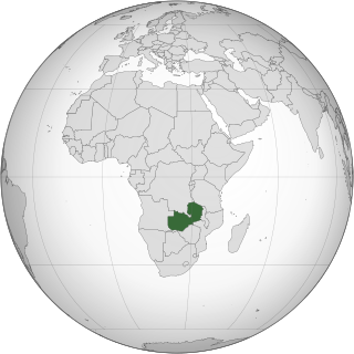
Zambia, officially the Republic of Zambia, is a landlocked country at the crossroads of Central, Southern and East Africa. It is typically referred to being in South-Central Africa or Southern Africa. It is bordered to the north by Democratic Republic of the Congo, Tanzania to the north-east, Malawi to the east, Mozambique to the southeast, Zimbabwe and Botswana to the south, Namibia to the southwest, and Angola to the west. The capital city of Zambia is Lusaka, located in the south-central part of Zambia. The population is concentrated mainly around Lusaka in the south and the Copperbelt Province to the north, the core economic hubs of the country.

Victoria Falls is a waterfall on the Zambezi River in southern Africa, which provides habitat for several unique species of plants and animals. It is located on the border between Zambia and Zimbabwe and is one of the world's largest waterfalls, with a width of 1,708 m (5,604 ft).

Lake Mweru is a freshwater lake on the longest arm of Africa's second-longest river, the Congo. Located on the border between Zambia and Democratic Republic of the Congo, it makes up 110 kilometres (68 mi) of the total length of the Congo, lying between its Luapula River (upstream) and Luvua River (downstream) segments.

The Luapula River is a north-flowing river of central Africa, within the Congo River watershed. It rises in the wetlands of Lake Bangweulu (Zambia), which are fed by the Chambeshi River. The Luapula flows west then north, marking the border between Zambia and the Democratic Republic of the Congo before emptying into Lake Mweru. The river gives its name to Zambia's Luapula Province.

Ndola is the third largest city in Zambia and third in terms of size and population, with a population of 475,194, after the capital, Lusaka, and Kitwe, and the second largest in terms of infrastructure development after Lusaka. It is the industrial and commercial center of the Copperbelt, Zambia's copper-mining region, and capital of Copperbelt Province. It lies just 10 kilometres (6.2 mi) from the border with DR Congo. It is also home to Zambia's first modern stadium, the Levy Mwanawasa Stadium.

The Victoria Falls Bridge crosses the Zambezi River just below the Victoria Falls and is built over the Second Gorge of the falls. As the river forms the border between Zimbabwe and Zambia, the bridge links the two countries and has border posts on the approaches to both ends, at the towns of Victoria Falls, Zimbabwe, and Livingstone, Zambia.

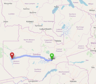
Livingstone is a city in Zambia. Until 1935, it served as the capital of Northern Rhodesia. Lying 10 km (6 mi) to the north of the Zambezi River, it is a tourism attraction center for the Victoria Falls and a border town with road and rail connections to Zimbabwe on the other side of the Victoria Falls. A historic British colonial city, its present population was enumerated at 177,393 inhabitants at the 2022 census. It is named after David Livingstone, the Scottish explorer and missionary who was the first European to explore the area. Until 2011, Livingstone was the provincial capital of Zambia's Southern Province.

Zambia Railways (ZR) is the national railway company of Zambia, one of the two major railway organisations in Zambia. The other system is the binational TAZARA Railway (TAZARA) that interconnects with the ZR at Kapiri Mposhi and provides a link to the Tanzanian port of Dar es Salaam.

The Great North Road is a major route in Zambia, running north from Lusaka through Kabwe, Kapiri Mposhi, Serenje, Mpika, Isoka and Nakonde to the border with Tanzania. The entire route is designated as the T2 road on Zambia's road network. It forms the Zambian section of the Tanzam Highway.

The Great East Road is a major road in Zambia and the main route linking its Eastern Province with the rest of the country. It is also the major link between Zambia and Malawi and between Zambia and northern Mozambique. However, the route does not carry as much traffic as many of the other regional arterial roads and between the main cities it serves, Lusaka and Chipata, it passes through rural and wilderness areas. In Lusaka the road forms the main arterial road for the eastern suburbs. The entire route from Lusaka to Chipata and the border with Malawi is designated the T4 road on Zambia's road network.

Southern Province is one of Zambia's ten provinces, and home to Zambia's premier tourist attraction, Mosi-oa-Tunya, shared with Zimbabwe. The centre of the province, the Southern Plateau, has the largest area of commercial farmland of any Zambian province, and produces most of the maize crop.

The Mulobezi Railway was constructed to carry timber from Mulobezi to Livingstone in the Southern Province of Zambia, when the country was Northern Rhodesia. The line uses the 1,067 mm narrow gauge, also known as 'Cape gauge', shared by all main line railways in Southern Africa.
This article gives lists of the National Monuments and other historic sites of Zambia, with a one- or two-line description providing links to details given on other pages.
Luangwa is a town in Zambia, at the confluence of the Luangwa and Zambezi Rivers, which was called Feira until 1964. It is headquarters of a district of the same name in Lusaka Province.
The Lusaka–Mongu Road of Zambia runs 580 km from the capital, Lusaka, to Mongu, capital of the Western Province. It connects that province to the rest of the country, as well as being one of two routes to the south-west extremity of North-Western Province. It also serves as the main highway of the western half of Central Province. The entire route from Lusaka to Mongu is designated as the M9 road.

The T1 or Lusaka–Livingstone Road is the main highway of the Southern Province of Zambia. It begins 55 kilometres south of the city of Lusaka and heads south-west to the principal tourist destination, Victoria Falls in Livingstone, via Mazabuka, Monze, Choma and Kalomo, measuring approximately 430 kilometres (267 mi). The entire route is part of Trans-African Highway network number 4 or Cairo-Cape Town Highway between Cairo and Cape Town.

Lusaka is the capital and largest city of Zambia. It is one of the fastest-developing cities in southern Africa. Lusaka is in the southern part of the central plateau at an elevation of about 1,279 metres (4,196 ft). As of 2019, the city's population was about 3.3 million, while the urban population is estimated at 2.5 million in 2018. Lusaka is the centre of both commerce and government in Zambia and connects to the country's four main highways heading north, south, east, and west. English is the official language of the city administration, while Bemba, Tonga, Lenje, Soli, Lozi, and Nyanja are the commonly spoken street languages.

The history of rail transport in Zambia began at the start of the twentieth century.
The history of the Jews in Zambia goes back to the early 1900s. Jews were always a small community with a notable role in Zambian history. The history of the Jews in Zambia dates to 1901 when it was still under British Colonial rule. Northern Rhodesia was colonized in the 1890s by the British South Africa Company, otherwise known as BSAC. Initially, Northern Rhodesia was split into North-eastern and North-western Rhodesia. However, the BSAC united them in 1911 to form Northern Rhodesia, which has its capital in Livingstone, near Victoria Falls. Among the population of 1 million people, there were 1,500 white residents in Northern Rhodesia, of whom many were the Jewish settlers. Northern Rhodesia became under British Colonial Rule partially so that the British Government could increase the number of white individuals and settlers in the country, which would contribute to a wider strategy to increase the influence that the British has between Kenya and South Africa. The Jewish settlers were one of the dominant ethnic groups and became highly involved in local politics, with prominent Jewish figures driving the push for Zambian independence and African nationalist rhetoric. Northern Rhodesia’s fertile land, World War II, and independence from the British Colonial rule all had a profound impact on both immigration and emigration of Jewish refugees. The Jewish diaspora introduced trade and commerce into the region in both regional and urban areas through cattle trading, ranching, mining, communication networks, storefronts, transport, and butchery, amongst others. The Jewish settlers, whether they are Jewish through origin, birth, marriage, or confession, all formed a small, yet strong community. The Jews in Zambia were a Jewish diaspora cultural and religious settler minority group, which raises concerns about the notion of who is the coloniser, who is the colonised, who is the victim and who is the oppressor. This deems that it can be studied through a postcolonial framework. Following Zambia's independence in 1964, there was a large exodus of Jews and white individuals from the country. In 2022, there remains less than fifty Jews in Zambia.

Barotziland–North-Western Rhodesia was a British protectorate in south central Africa formed in 1899. It encompassed North-Western Rhodesia and Barotseland.


