This is a list of bridges in North Korea .
This is a list of bridges in North Korea .
Six bridges over the Taedong River, in order west to east

The Yalu River or Amnok River is a river on the border between China and North Korea. Together with the Tumen River to its east, and a small portion of Paektu Mountain, the Yalu forms the border between China and North Korea. Its valley has been the scene of several military conflicts in the past centuries. It borders North Korea to the south and China to the north.

The Tumen River, also known as the Tuman River or Duman River, is a 521-kilometre (324 mi) long river that serves as part of the boundary between China, North Korea (right) and Russia (left), rising on the slopes of Mount Paektu and flowing into the Sea of Japan. The river has a drainage basin of 33,800 km2 (13,100 sq mi).

The Battle of the Yalu River lasted from April 30 to May 1, 1904 and was the first major land battle during the Russo-Japanese War. It was fought near Wiju on the lower reaches of the Yalu River, on the border between Korea and China. Also known as the Yalu River Crossing Operation.

The Sino-Korean Friendship Bridge, or China–North Korea Friendship Bridge, is a bridge across the Yalu or Amnok River on the China–North Korea border. It connects the cities of Dandong in China and Sinuiju of North Korea, by railway and roadway but pedestrians are not allowed to cross between either side. The bridge serves as one of the few ways to enter or leave North Korea.

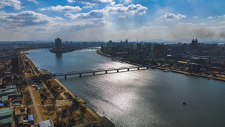
The Taedong River (Korean: 대동강) is a large river in North Korea. The river rises in the Rangrim Mountains of the country's north where it then flows southwest into Korea Bay at Namp'o. In between, it runs through the country's capital, Pyongyang. Along the river are landmarks such as the Juche Tower and Kim Il-sung Square.

Korea comprises the Korean Peninsula and 3,960 nearby islands. The peninsula is located in Northeast Asia, between China and Japan. To the northwest, the Yalu River separates Korea from China and to the northeast, the Tumen River separates Korea from China and Russia. The Yellow Sea lies to the west, the East China Sea and Korea Strait to the south, and the Sea of Japan to the east. Notable islands include Jeju, Ulleung, and the Liancourt Rocks.

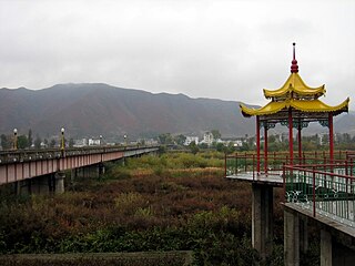
The Rungra Bridge is a bridge in Pyongyang, North Korea, one of the city's six bridges on the Taedong River. Located between the Okryu Bridge to the south and Chongryu Bridge to the north, it connects Moranbong-guyok on the right (west) bank of the Taedong River with Taedonggang-guyok on the left bank, passing through Rungra Island in the middle. It totals 1,070 metres (3,510 ft) in length. It was completed in 1988.
Rungra Island is an island in Pyongyang, North Korea, located in the middle of the Taedong River. Its total area is 1.3 square kilometres (0.50 sq mi). The Chongryu Bridge on the north side and the Rungra Bridge on the south side connect the island to the rest of Pyongyang. Some of the Eight Views of Pyongyang can be seen from the island.

The Ji'an Yalu River Border Railway Bridge is a single-track railway bridge that spans the Yalu River and connects the outskirts of the Chinese town of Ji'an in Jilin Province with the North Korean town of Manp'o in Chagang Province.

The New Yalu River Bridge, or Korea-China Amnok River Bridge, is a road bridge across the Amnok River between Dandong, Liaoning Province, China, and Sinuiju, North Korea. The cable-stayed bridge, which is 3 kilometers (1.9 mi) long including the supporting roads, is intended as a replacement for the Sino-Korean Friendship Bridge. Construction began in October 2011 and is mostly complete and connected with Xingdan Road, but the project stalled between 2014 and 2019, with work unfinished on the North Korean side. By 2021, construction on the North Korean side has been mostly completed, with the bridge being expected to open soon.

The Changbai–Hyesan International Bridge is a bridge over the Yalu River, connecting Changbai Korean Autonomous County of Changbai City, Jilin Province, China, with Hyesan City of Ryanggang Province, North Korea. It was initially built in 1936 by the Japanese, and, after several destructions and rebuildings, was renewed in 1985 as the present-day bridge, which is 148 meters (486 ft) long and 9 meters (30 ft) wide. Since 1992, one-day, five-day and ten-day tours have been conducted between China and North Korea.

The Linjiang Yalu River Bridge is a bridge over the Yalu River, connecting Linjiang City, Jilin Province, China, with Chunggang County, Chagang Province, North Korea. It was built by the Japanese in 1938 and Linjiang Border Post is located there. A little downstream from the bridge is Yunfeng Dam.
The Tumen Border Bridge is a bridge over the Tumen River, connecting Tumen City, Jilin Province, China, with Namyang, Onsong County, North Hamgyong Province, North Korea. It was built in 1941 by the Japanese and is 515 metres long, 6 metres high, 6 metres wide. Tumen Border Post is located there. A little upstream from the bridge is Tumen Border Railway Bridge.

The Tumen River Bridge crosses the Tumen River between Quanhe, where the Quan River enters the Tumen River in Jilin Province, China, and Wonjong in Rason, North Korea. It is the international link in a road route between Hunchun City in China and Sonbong-guyok in Rason.

The China–North Korea border is an international border separating China and North Korea, extending from Korea Bay in the west to a tripoint with Russia in the east. The total length of the border is 1,352 kilometers (840 mi). The current border was created by two secret treaties signed between China and North Korea in 1962 and 1964.
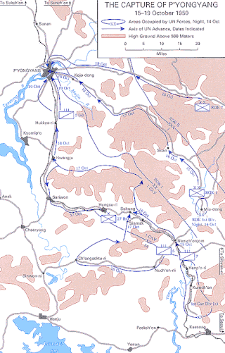
The Battle of Pyongyang was one of the major battles of the United Nations' offensive during the Korean War. Following the Battle of Inchon, the UN forces re-captured Seoul, the capital of South Korea, and proceeded to advance into North Korea. Shortly after advancing, the American and South Korean forces faced the North Korean defenses near Pyongyang, the capital of North Korea, on 17 October.

The Chungsong Bridge is the westernmost major road bridge across the Taedong River in Pyongyang. It connects Pyongchon District on the northern side to Rangrang District on the southern side. The bridge was opened to traffic on September 6, 1983.
Ssuksom is a small island in the Taedong River in Pyongyang, North Korea, separated by a shallow channel from the larger Turu Island to its west. Since 1983 it has been accessible by road via an off-ramp in the middle of the Chungsong Bridge. It is the site of the new Pyongyang Sci-Tech Complex completed in 2015.

Yanggak Bridge (양각교) is the second (west–east) of the six major bridges on the Taedong River in Pyongyang. The middle of the bridge has an off-ramp to Yanggak Island.
The Taedong Bridge (Korean: 대동교) is a bridge over the Taedong River in Pyongyang, North Korea.