List of bridges in Nepal

Last updated

This list of bridges of Nepal draws up an inventory of the remarkable bridges of Nepal, as well by their dimensional characteristics, as by their architectural or historical interest.

Contents

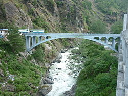
The long suspension bridges of Nepal

In 2015, Nepal had a total road network of 80,078 kilometres (49,758 mi) of which 53,143 kilometres (33,022 mi) are local rural roads, of these, only 1,697 kilometres (1,054 mi) has been black-topped. [1] Modern roads are few and mostly concentrated on the Terai plain, the area stretching along the border with India and which accounts for nearly half of the country's population. In 2020, there is only one railway line of 59 kilometers, also located near India and the capital Kathmandu has no railway connection. [2] The population is essentially rural in this region at the foot of the Himalayas, but the steep reliefs are a brake on the development of the local populations who are already among the poorest in the world.

Yaks on a suspension bridge near Namche Bazaar at the foothills of the Himalayas. Steel bridge being crossed by yaks.jpg
Yaks on a suspension bridge near Namche Bazaar at the foothills of the Himalayas.
Tigram Suspension Bridge ( length : 98m) which connects India and Nepal. View from Nepali side Tigram.jpg
Tigram Suspension Bridge ( length : 98m) which connects India and Nepal. View from Nepali side

Until the 1950s, the whole country with the exception of the Terai was provided only with trails for a large part of the territory, some essential trade routes had been established since the beginning of the 20th century, despite the isolation of the Nepal. Louis Harper introduced the first modern suspension footbridges to Nepal in the late 1890s, he had improved the system in the United Kingdom from wooden pylons to steel lattice pylons, they were pre-fabricated in Scotland and shipped to site for assembly. At least 4 bridges of this type remain in service in Nepal today. [3] This system was unfortunately not effective and failed to meet significant demand.

All these constraints led the government to create the Suspension Bridges Division in 1964 (replaced by the Trail Bridge Section in 2001) which studied with Swiss engineers a model of durable, easy-to-build simple suspension bridge, adapted to the Nepalese relief and therefore to large spans ranging from 120 to 350 metres (390 to 1,150 ft), and a whole first generation of trail bridges was born on the main axes, with up to 30 bridges built per year. Under an increasingly strong demand, a second generation of bridges had developed with economic and environmental stakes, these bridges are optimized to be built with local materials and carried out by a local workforce in order to extend this system across the country. They will nevertheless have shorter spans than the first generation bridges, in the order of 40 to 120 meters.

By 2004, more than 3000 suspension bridges have thus been built on the Nepalese landscape including 2230 bridges through Swiss support with an overall length of more than 180 kilometres (110 mi). [4] Two types of bridges have been built: 580 long-span trail bridges with lengths ranging from 120 to 350 metres (390 to 1,150 ft) on the main trails under the responsibility of the Department of Local Infrastructure Development and Agricultural Roads and 1650 short-span community bridges up to 120 metres (390 ft) in length, built by the communities themselves under the responsibility of User Committees. [5] In September 2015, a total of 6000 completed trail bridges has been celebrated. [6]

But the needs are still numerous and signs of weakness are beginning to appear, it is estimated that 200 the number of bridges require heavy work, even replacement (statistics mid-2004). Some footbridges are built on great heights in order to fight against flooding during the monsoon, 14 bridges were destroyed during the glacial break-up of Digcho in the Sagarmatha area in 1985. This phenomenon, also called jökulhlaup, is caused by the rupture of a glacier and causes sudden and devastating floods. The devastated bridges were later rebuilt on higher levels.

They are rediscovered today by tourists during organized backpackings on the footpaths of Everest, Annapurna, the Kathmandu Valley and other sites along Nepal.

Historical and architectural interest bridges

Among the notables bridges of Nepal, we can mention the Dodhara Chandani Bridge which has the originality of being composed of 4 successive suspension bridges with three spans, and a total of 8 large steel truss pylons, which spans nearly 1,500 meters. [7] Its four main spans have very large arrows and each is held by lateral support cables. The bridge is designed as a pedestrian bridge, but bicycles and motorcycles can use the bridge as well. There is enough room so that motorcycles can pass even if they are fully loaded. All traffic travels on the left-hand side, as everywhere else in Nepal.

The bridges presented here are initially sorted by date of commissioning, they thus retrace part of the history of transport in Nepal and the various developments that led to the structures that can be seen today.

NameNepaliDistinctionLengthTypeCarries
Crosses
OpenedLocationProvinceRef.
Pont a encorbellement 001.jpg 1Common kind of bridge in Nepal Cantilever Log bridge
Wood
[8]
Nepal 2018-03-26 (41731486672).jpg 2 Larja Dobhan Footbridge Sagarmatha National Park
World Heritage Logo global.svg World Heritage Site (1979)
Suspension
Steel
Footbridge (Lukla - Everest Base Camp Trekking Route)
Dudh Koshi
Namche Bazaar
27°47′24.2″N86°43′07.7″E / 27.790056°N 86.718806°E / 27.790056; 86.718806 (Larja Dobhan Footbridge)
Province No. 1 [9]
The Friendship Bridge connecting China with Nepal.jpg 3 Sino-Nepal Friendship Bridge
closed in 2015
मितेरी पुल China–Nepal border Arch
Concrete deck arch
1965 Kodari Zhangmu
27°58′24.8″N85°57′50.7″E / 27.973556°N 85.964083°E / 27.973556; 85.964083 (Sino-Nepal Friendship Bridge)
Bagmati Province
Flag of the People's Republic of China.svg  China
[10]
[11]
Dodhara Chandani Multispan Pedestrian Bridge1.jpg 4 Dodhara Chandani Bridge दोधारा चाँदनी पुलSpan : 225 m (738 ft) (x4)1,453 m (4,767 ft) Suspension
Steel, 8 pylons
Footbridge
Sharda River
2005 Mahakali
28°55′20.8″N80°06′27.2″E / 28.922444°N 80.107556°E / 28.922444; 80.107556 (Dodhara Chandani Bridge)
Sudurpashchim Province [S 1]
[7]
Bungy The Last Resort, Nepal P5166787.jpg 5 Bhote Kosi Bungee Footbridge भोटेकोसी बन्जी पुल Bungee jumping spot
Height : 160 m (520 ft)
166 m (545 ft) Suspension
Steel
Footbridge
Bhote Koshi
1999 Listikot Gathi
27°52′33.0″N85°53′32.8″E / 27.875833°N 85.892444°E / 27.875833; 85.892444 (Bhote Kosi Bungee Bridge)
Bagmati Province [S 2]
6 Tinmukhe Bridge तिनमुखे पुल Three-way suspension bridge
Tri-junction of Gulmi, Palpa and Syangja districts
Suspension
Steel
2021 Ruru Kshetra
27°56′05.3″N83°26′22.8″E / 27.934806°N 83.439667°E / 27.934806; 83.439667 (Tinmukhe Bridge)
Lumbini Province
Gandaki Province
[12]

Major road bridges

Nepal's largest road bridge, the Karnali Bridge, was designed by Steinman, Boynton, Gronquist & Birdsall of USA, constructed by Kawasaki Heavy Industries of Japan [13] and funded by the World Bank. [14] It is part of the country's largest highway, the Mahendra Highway H01, which crosses the Terai region from east to west and over Nepal's longest and widest river, the Ghaghara (also called Karnali) which ends in the Ganges. The Karnali Bridge is the only road bridge with a span of more than 300 meters in Nepal, the H01 highway like the other highways in the country, avoids major obstacles as much as possible, such as the many rivers resulting from melting snow of the Himalayas and overly mountainous areas which would require much more expensive infrastructure. The very underdeveloped railway network is an additional reason for the scarcity of major bridges other than footbridges in Nepal. This table presents the structures with spans greater than 100 metres (330 ft) (non-exhaustive list).

NameNepaliSpanLengthTypeCarries
Crosses
OpenedLocationProvinceRef.
KARNALI BRIDGE.jpg 1 Karnali Bridge कर्णाली पुल325 m (1,066 ft)500 m (1,600 ft) Cable-stayed
Steel truss deck, 1 steel pylon
325+175
1993 Chisapani
28°38′28.5″N81°16′59.8″E / 28.641250°N 81.283278°E / 28.641250; 81.283278 (Karnali Bridge)
Lumbini Province
Sudurpashchim Province
[S 3]
[13]
Mugling Bridge Prithivi Highway.jpg 2 Mugling Bridge मुग्लिङमा पुल125 m (410 ft) Suspension
Steel truss deck, concrete pylons
1972 Mugling
27°51′14.4″N84°33′26.0″E / 27.854000°N 84.557222°E / 27.854000; 84.557222 (Mugling Bridge)
Gandaki Province
Bagmati Province
[15]
3 Dudhkoshi Jayaramghat Bridge दूध कोशी जयराम घाट पुल122 m (400 ft)150 m (490 ft) Suspension
Steel truss deck, concrete pylons
Road bridge
Jairam Ghat road
Diktel road
Dudh Koshi
2017 Thakle Ainselu Kharka
27°10′36.0″N86°28′25.0″E / 27.176667°N 86.473611°E / 27.176667; 86.473611 (Dudhkoshi Jayaramghat Bridge)
Province No. 1 [16]
[17]
4 Arun River Bridge अरुण लेगुवा पुल120 m (390 ft)120 m (390 ft) Truss
Steel
Road bridge
Arun River
2013 Leguwa Jarayotar
27°08′23.5″N87°16′02.6″E / 27.139861°N 87.267389°E / 27.139861; 87.267389 (Arun River Bridge)
Province No. 1 [18]
[19]
5 Sabha Khola Bridge सभा खोला पुल120 m (390 ft)120 m (390 ft) Truss
Steel
Road bridge
Sabha River
2013 Tumlingtar
27°17′20.1″N87°12′46.1″E / 27.288917°N 87.212806°E / 27.288917; 87.212806 (New Mugling Bridge)
Province No. 1 [18]
[20]
6 New Mugling Bridge मुग्लिन आर्क ब्रिज120 m (390 ft)160 m (520 ft) Arch
Concrete deck arch
2019 Mugling
27°51′16.7″N84°33′26.6″E / 27.854639°N 84.557389°E / 27.854639; 84.557389 (New Mugling Bridge)
Gandaki Province
Bagmati Province
[21]

Major footbridges

This table presents suspension footbridges with spans greater than 300 metres (980 ft) (non-exhaustive list).

NameNepaliSpanHeightTypeCarries
Crosses
OpenedLocationProvinceRef.
1 Gandaki Golden Footbridge गण्डकी गोल्डेन झोलुङ्गे पुल567 m (1,860 ft)122 m (400 ft) Simple suspension
Steel, wind guy-wires
Footbridge
Gandaki River
2020 Kushma Baglung District
28°15′42.1″N83°36′34.9″E / 28.261694°N 83.609694°E / 28.261694; 83.609694 (Gandaki Golden Footbridge)
Gandaki Province [22]
[23]
2 Kushma Bungy Footbridge कुश्मा बन्जी जम्पिङ490 m (1,610 ft)200 m (660 ft) Simple suspension
Steel
Footbridge
Gandaki River
2019 Kushma Narayansthan
28°13′21.1″N83°40′21.5″E / 28.222528°N 83.672639°E / 28.222528; 83.672639 (Kushma Bungy Footbridge)
Gandaki Province [Note 1]
[25]
[24]
3 Kushma Mudikuwa Footbridge कुश्मा मुडिकुवा पुल359 m (1,178 ft)117 m (384 ft) Simple suspension
Steel, wind guy-wires
Footbridge
Modi Khola
2016 Kushma Mudikuwa
28°12′07.4″N83°40′21.3″E / 28.202056°N 83.672583°E / 28.202056; 83.672583 (Kushma Mudikuwa Footbridge)
Gandaki Province [Note 2]
[26]
4 Triveni Garas Footbridge 350 m (1,150 ft) Suspension
Steel
Footbridge
Kamala River
2010 Dudhauli Katari Municipality
26°55′43.8″N86°15′54.6″E / 26.928833°N 86.265167°E / 26.928833; 86.265167 (Triveni Garas Footbridge)
Bagmati Province
Province No. 1
[28]
5 Bunwajor Ghat II Footbridge 349 m (1,145 ft) Suspension
Steel
Footbridge
Dudh Koshi
1996 Bopun Chaudandi
26°54′09.3″N86°55′16.2″E / 26.902583°N 86.921167°E / 26.902583; 86.921167 (Bunwajor Ghat II Footbridge)
Province No. 1 [29]
Badagaun-Kaiyan trail bridge.jpg 6 Kushma Balewa Bridge कुश्मा बलेवा पुल347 m (1,138 ft)117 m (384 ft) Simple suspension
Steel, wind guy-wires
Footbridge
Gandaki River
2013 Kushma Narayansthan
28°12′16.5″N83°40′17.3″E / 28.204583°N 83.671472°E / 28.204583; 83.671472 (Kushma Balewa Bridge)
Gandaki Province [Note 3]
[30]
aglo pul.jpg 7 Kushma-Gyadi Footbridge कुश्मा ग्यादी झोलुङ्गे पुल344 m (1,129 ft)117 m (384 ft) Simple suspension
Steel, wind guy-wires
Footbridge
Modi Khola
2010 Kushma
28°12′33.6″N83°40′42.1″E / 28.209333°N 83.678361°E / 28.209333; 83.678361 (Kushma-Gyadi Footbridge)
Gandaki Province [Note 4]
[34]
[32]
8 Sheramalakot Footbridge 336 m (1,102 ft) Suspension
Steel
Footbridge
Tadi River
2011 [35]
9 Budhsingaratmate Footbridge 311 m (1,020 ft) Simple suspension
Steel
Footbridge
Trishuli River
2011 Ratmate Budhsing
27°51′28.2″N85°03′28.6″E / 27.857833°N 85.057944°E / 27.857833; 85.057944 (Budhsingaratmate Footbridge)
Bagmati Province [35]
10 Leguwa Ghat Footbridge 310 m (1,020 ft) Suspension
Steel
Footbridge
Arun River
1982 Leguwa Jarayotar
27°08′44.5″N87°16′16.3″E / 27.145694°N 87.271194°E / 27.145694; 87.271194 (Leguwa Ghat Footbridge)
Province No. 1 [36]

See also

Map all coordinates using: OpenStreetMap

Notes and references

  1. According to the sources, the span would be between 490 and 520 metres (1,610 and 1,710 ft) [24] [25] and the height between 200 and 228 metres (656 and 748 ft).
  2. The given height varies between 117 and 155 metres (384 and 509 ft). [26] [27]
  3. Also known as Badagaun-Kaiyan Trail Bridge, the height is reported between 117 and 157 metres (384 and 515 ft). [30] [31]
  4. According to the sources, the height would be between 117 and 135 metres (384 and 443 ft). [32] [33]
  1. "Total road length crosses 80,000km". The Himalayan Times. July 13, 2015. Retrieved December 12, 2022.
  2. "Department of Railways". Dorw.gov.np - Ministry of Physical Infrastructure and Transport - Government of Nepal. Retrieved December 12, 2022.
  3. "Harper Bridges - Introduction". Harperbridges.com. Archived from the original on February 7, 2012.
  4. Asia Brief - Trail Bridges In Nepal, 2006, p.1
  5. Asia Brief - Trail Bridges In Nepal, 2006, p.2
  6. Sapkota, 2017, p.140
  7. 1 2 "Program & Projects - Dodhara Chandani Multispan Pedestrian Bridge". Dolidar.gov.np. Department of Local Infrastructure Development and Agricultural Roads, Government of Nepal. Archived from the original on August 2, 2007.
  8. "New Bridges Move Mountain People". Agenda. Vol. 1 & 2. Press and Publications Division, Office of Public Affairs, Agency for International Development. 1978. p. 15.
  9. "Sagarmatha National Park". Whc.unesco.org. Retrieved December 12, 2022.
  10. Gautam, Upendra (March 2003). South Asia and China: Towards Inter-Regional Cooperation (PDF). Kathmandu, Nepal: China Study Center. p. 129. ISBN   99933-53-33-7 . Retrieved December 12, 2022.
  11. "Sino-Nepal 'friendship bridge' reconstruction begins after taking 2015 quake damage". Devdiscourse.com. November 17, 2018. Retrieved December 12, 2022.
  12. "रुरु क्षेत्र रिडीमा १४ करोडको तीनमुखे पुल निर्माण सकिन लाग्यो" [The construction of a three-way bridge worth 140 million has been completed in Riddi, Ruru area]. Globalaawaj.com (in Nepali). Retrieved December 12, 2022.
  13. 1 2 Shrestha, Bipin; Tuladhar, Roshan (December 2012). "The response of Karnali Bridge, Nepal to near-fault earthquakes". Proceedings of the Institution of Civil Engineers - Bridge Engineering. 165 (BE4): 223–232. doi:10.1680/bren.9.00037. ISSN   1478-4637 . Retrieved December 12, 2022.
  14. Dave Reed; James McConnachie (2015-07-01). "The western terai- the far west". The Rough Guide to Nepal. Rough Guides UK. pp. 276–277. ISBN   978-0-241-23810-3.
  15. Shrestha, Jagat Kumar (April 2016). "Effect of Modification of Deck Properties on Suspension Bridges". Journal of the Institute of Engineering. Vol. 12. pp. 39–50.{{cite book}}: |website= ignored (help)
  16. Jaishi, Bijaya (March 2021). "Dudhkoshi Motorable Suspension Bridge". Newsletter - Department of Roads. Vol. 25. Lalitpur, Nepal. pp. 3–6.{{cite book}}: |website= ignored (help)CS1 maint: location missing publisher (link)
  17. "Newly constructed bridge over Dudhkoshi links eastern hill districts". The Kathmandu Post. November 24, 2017. Retrieved December 12, 2022.
  18. 1 2 Bridges - Spanning the world since 1919 (PDF). December 2014. Retrieved December 12, 2022.{{cite book}}: |website= ignored (help)
  19. "120 metre Arun River Steel Truss Bridge". Steel-bridges.com - John REID & Sons Ltd. Retrieved December 12, 2022.
  20. "Sabha Khola". Steel-bridges.com - John REID & Sons Ltd. Retrieved December 12, 2022.
  21. Jaishi, Bijaya (August 2021). "Design and Construction of Mugling Deck Arch Bridge" (PDF). Newsletter - Department of Roads. Vol. 26. Lalitpur, Nepal. pp. 1–4.{{cite book}}: |website= ignored (help)CS1 maint: location missing publisher (link)
  22. "World's longest suspension bridge over Kaligandaki River given name". Nepalnews.com. Retrieved December 12, 2022.
  23. "Gandaki Golden Footbridge". Highestbridges.com. Retrieved December 12, 2022.
  24. 1 2 "Kushma Bungy Footbridge". Highestbridges.com. Retrieved December 12, 2022.
  25. 1 2 "Kushma Bungee Jump". Kushmabungeejump.com. 3 November 2020. Retrieved December 12, 2022.
  26. 1 2 "Kushma Mudikuwa Footbridge". Highestbridges.com. Retrieved December 12, 2022.
  27. "म्याग्दीको बेगखोलामा मुलुककै लामो झोलुङ्गे पुल" [The country's longest suspension bridge at Begkhola in Myagdi]. Ghatanarabichar.com (in Nepali). Retrieved December 12, 2022.
  28. Nepal Trail Bridge Record, p.36
  29. Nepal Trail Bridge Record, p.29
  30. 1 2 "Kushma Balewa Footbridge". Highestbridges.com. Retrieved December 12, 2022.
  31. "पर्वतमा लामा र अग्ला पुल बनाउने होड" [A bid to build a long and high bridge in the mountains]. Ghatanarabichar.com (in Nepali). Retrieved December 12, 2022.
  32. 1 2 "Kushma Gyadi Footbridge". Highestbridges.com. Retrieved December 12, 2022.
  33. "मुलुककै लामा र अग्ला झोलुङ्गे पुल हेर्न पर्यटकको घुइँचो" [Tourists flock to see the longest and highest suspension bridge in the country]. Purbelinews.com (in Nepali). Retrieved December 12, 2022.
  34. Nepal Trail Bridge Record, p.80
  35. 1 2 Nepal Trail Bridge Record, p.54
  36. Nepal Trail Bridge Record, p.20

Further reading

Related Research Articles

<span class="mw-page-title-main">Geography of Nepal</span>

Nepal measures about 880 kilometers (547 mi) along its Himalayan axis by 150 to 250 kilometers across. It has an area of 147,516 km2 (56,956 sq mi).

<span class="mw-page-title-main">Lalitpur, Nepal</span> City in Bagmati Province, Nepal

Lalitpur Metropolitan City is a Metropolitan city and fourth most populous city of Nepal with 299,843 inhabitants living in 49,044 households per the 2021 census. It is located in the south-central part of Kathmandu Valley, a large valley in the high plateaus in central Nepal, at an altitude of 1,400 metres.

<span class="mw-page-title-main">Kathmandu Valley</span> Valley and proposed territory in Nepal

The Kathmandu Valley, also known as the Nepal Valley or Nepa Valley, National Capital Area, is a bowl-shaped valley located in the Himalayan mountains of Nepal. It lies at the crossroads of ancient civilizations of the Indian subcontinent and the broader Asian continent, and has at least 130 important monuments, including several pilgrimage sites for Hindus and Buddhists. There are seven World Heritage Sites within the valley.

<span class="mw-page-title-main">Dhangadhi</span> Sub-Metropolitan City in Sudurpashchim Province, Nepal

Dhangadhi is a sub-metropolitan city and the district headquarters of Kailali District in Sudurpashchim Province of Nepal. It shares a border with Uttar Pradesh, India in the south, Godawari and Gauriganga Municipality in the North, Kailari Rural Municipality in the east and Kanchanpur District in the west. Dhangadhi is a sub-metropolis divided into 19 wards. It has a population of about 147,181 and thus is the 10th biggest city of Nepal. It has an area of 261.75 km2 (101.06 sq mi). It is one of the major cities of Far - West Province of Nepal along with Mahendranagar.

<span class="mw-page-title-main">Achham District</span> District in Sudurpashchim Province, Nepal

Achham is a district located in Sudurpashchim province of Nepal. It is one of the nine districts of the province. The district, with Mangalsen as its district headquarters, covers an area of 1,692 km2 and has a population (2011) of 257,477.

<span class="mw-page-title-main">Kathmandu District</span> District in Bagmati Province, Nepal

Kathmandu District is a district located in Kathmandu Valley, Bagmati Province of Nepal. It is one of the 77 districts of Nepal, covers an area of 413.69 km2 (159.73 sq mi), and is the most densely populated district of Nepal with 1,081,845 inhabitants in 2001, 1,744,240 in 2011 and 2,017,532 in 2021. The administrative headquarters of Kathmandu district is located in Kathmandu. The city has 21 post offices which handle mail from across the country and beyond, with Kathmandu DPO having 44,600 as its postal code for international mail delivery services like UPS or DHL Couriers etc.

<span class="mw-page-title-main">Rukum District</span> Former District in Nepal

Rukum District was a "hill" and "mountain" district some 280 km (170 mi) west of Kathmandu partially belonging to Lumbini Province and partially to Karnali Province before split into two districts Western Rukum and Eastern Rukum after the state's reconstruction of administrative divisions in 2017. Rukum covers an area of 2,877 km2 (1,111 sq mi) with population of 207,290 in 2011 Nepal census. Musikot was the district's administrative center.

<span class="mw-page-title-main">Surkhet District</span> District of Nepal in Karnali Province

Surkhet District is a district in Karnali Province of mid-western Nepal. Surkhet is one of the ten districts of Karnali located about 600 kilometres (373 mi) west of the national capital Kathmandu. The district's area is 2,489 square kilometres (961 sq mi). It had 288,527 population in 2001 and 350,804 in 2011 which male comprised 169,461 and female 181,381. Its district headquarters, Birendranagar, is the capital of Karnali Province. It is serving as a business hub and document center for Karnali province. According to population, development, road links, landforms, climate, many peoples are migrating here. After becoming province capital developmental activities are boosted and are in peak level. All the governmental works are carried here. Birendranagar is beautiful valley surrounded by hills having moderate climate.

<span class="mw-page-title-main">Baglung</span> Place in Gandaki Province, Nepal

Baglung is a municipality in Gandaki Province, in western Nepal, 275 km (171 mi) west of Kathmandu. It is the administrative headquarters of Baglung District. Baglung serves as the major center for business, finance, education, service and healthcare for the people of mid-Kali Gandaki valley that encompass Beni, Jaljala, Baglung, Kushma, Kathekhola, Galkot, Phalewas and Jaimuni local bodies. The city is located at the cross-section of Kaligandaki corridor highway and midhill highway that transverse Nepal in north–south and east–west directions respectively.

<span class="mw-page-title-main">Bhimdatta</span> Municipality in Sudurpashchim Province, Nepal

Mahendranagar, officially known as Bhimdattanagar, is a municipality in Kanchanpur District of Sudurpashchim Province, Nepal. The city and the municipality were named Mahendranagar in honour of the late King Mahendra of Nepal. After becoming a republic in 2008, the Mahendranagar municipality name was changed to Bhimdatta municipality in honour of the revolutionary farmer leader Bhimdatta Panta. It is surrounded by Bedkot Municipality in the east, Dadeldhura District in the north, Shuklaphanta National Park in the south and Uttarakhand, India in the west.

<span class="mw-page-title-main">Mahendra Highway</span> Major road in Nepal

Mahendra Highway, also called East-West Highway, runs across the Terai geographical region of Nepal, from Mechinagar in the east to Bhim Datta in the west, cutting across the entire width of the country. It is the longest highway in Nepal and was constructed by cooperation of various countries. The highway is named after King Mahendra Shah.

<span class="mw-page-title-main">Tharu languages</span> Indo-Aryan language group of Nepal and India

The Tharu or Tharuhat languages are any of the Indo-Aryan languages spoken by the Tharu people of the Terai region in Nepal, and neighboring regions of Uttarakhand, Uttar Pradesh and Bihar in India.

<span class="mw-page-title-main">Musikot, Western Rukum</span> Municipality in Karnali Province, Nepal

Musikot is a municipality and the district headquarter of Western Rukum District in Karnali Province of Nepal that was established as Musikot Khalanga on 2 December 2014 by merging the two former Village development committees Musikot and Khalanga. From 2014 until 2018, Musikot was called Musikot Khalanga and until 2017 served as the district headquarter of Rukum District. It lies on the bank of Sani Bheri River. It borders with Eastern Rukum in the east, Sanibheri rural municipality in the west, Banfikot rural municipality in the north and Tribeni rural municipality and Rolpa district in the south.

<span class="mw-page-title-main">Sino-Nepal Friendship Bridge</span> Bridge linking Nepal and China

The Sino-Nepal Friendship Bridge is a bridge spanning the Sun Kosi river, linking Kodari in Sindhulpalchok District, Nepal, and Zhangmu, China.

<span class="mw-page-title-main">Satya Mohan Joshi</span> Nepali writer and scholar (1920–2022)

Satya Mohan Joshi was a Nepalese writer and scholar. Joshi is known for his research on the history and culture of Nepal. He also served as the chancellor of the Nepal Bhasa Academy.

<span class="mw-page-title-main">Dodhara Chandani Bridge</span> Bridge in Kanchanpur district, Mahakali Nepal

The Dodhara Chandani Bridge, commonly known as Mahakali Bridge is a suspension bridge for pedestrians and at this point only about 1452.5 m long over Mahakali River in the far west of Nepal.

<span class="mw-page-title-main">Former administrative units of Nepal</span> Former administrative divisions of Nepal

Former administrative units of Nepal are administrative divisions during Kingdom of Nepal. In 2008 Nepal was proclaimed a federal republic and old administrative units restricted after adoption of new constitution on 20 September 2015.

<span class="mw-page-title-main">Western Rukum District</span> District in Karnali Province, Nepal

Western Rukum a part of Karnali Province, is one of the seventy-seven districts of Nepal. Musikot is the headquarter of the district.

Gandaki Golden Bridge is a suspended footbridge with a span of 567m. It connects the Kusma Municipality of Parbat district at Aduwabari with Baglung Municipality 1 bangechour of Baglung District in Nepal. The bridge is over the Kaligandaki river. The height of bridge is 122 m from the river level. It became the second longest bridge of its kind in May 2022 after the opening of Sky Bridge 721 in Czech Republic, prior to that it was the world's longest foot bridge.