Upper Mustang is an upper part of Mustang District, which is located in Nepal. The Upper Mustang was a restricted kingdom until 1992 which makes it one of the most preserved regions in the world, with a majority of the population still speaking traditional Tibetic languages. Tibetan culture has been preserved by the relative isolation of the region from the outside world. Life in Mustang revolves around tourism, animal husbandry, and trade.

The Qinghai–Tibet railway or Qingzang railway, is a high-elevation railway line in China between Xining, Qinghai Province, and Lhasa, Tibet. With over 960 km (600 mi) of track being more than 4,000 m (13,123 ft) above sea level, it is the highest railway line in the world.

Nathu La(Tibetan: རྣ་ཐོས་ལ་, Wylie: Rna thos la, THL: Na tö la, Sikkimese: རྣ་ཐོས་ལ་) is a mountain pass in the Dongkya Range of the Himalayas between China's Yadong County in Tibet, and the Indian states of Sikkim. But minor touch of Bengal in South Asia. The pass, at 4,310 m (14,140 ft), connects the towns of Kalimpong and Gangtok to the villages and towns of the lower Chumbi Valley.

The Friendship Highway is an 800-kilometre (500 mi) scenic route connecting the capital of Tibet, Lhasa, with the Chinese/Nepalese border at the Sino-Nepal Friendship Bridge between Zhangmu and Kodari. It includes the westernmost part of China National Highway 318 (Shanghai-Zhangmu) and crosses three passes over 5,000 m (16,400 ft) before dropping to 1,750 m (5,700 ft) at the border.

Nyalam is a small town in and the county seat of Nyalam County in the Shigatse Prefecture of the Tibet Autonomous Region, near the Nepal border. It is 35 km from Zhangmu town in the same county, which is the point of entry to Nepal. Nyalam is situated at 3,750 metres (12,300 ft) above sea level.

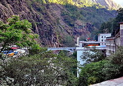
Zhangmu or Dram in Tibetan, or Khasa in Nepali, is a customs town and port of entry located in Nyalam County in Tibet, China close to the Nepal-China border, just uphill and across the Bhotekoshi River from the Nepalese town of Kodari. At 2,300 metres (7,500 ft) above sea level, Zhangmu has a mild and humid subtropical climate, which is a rarity for Tibet.
The bilateral relations between Nepal and China are defined by the Sino-Nepalese Treaty of Peace and Friendship signed on April 28, 1960, by the two countries. Though initially unenthusiastic, Nepal has been of late making efforts to increase trade and connectivity with China. Relations between Nepal and China got a boost when both countries solved all border disputes along the China–Nepal border by signing the Sino-Nepal boundary agreement on March 21, 1960, making Nepal the first neighboring country of China to conclude a border treaty with China. The governments of both Nepal and China ratified the border treaty on October 5, 1961. From 1975 onward, Nepal has maintained a policy of balancing the competing influence of China and Nepal's southern neighbor India, the only two neighbors of the Himalayan country after the accession of the Kingdom of Sikkim into India in 1975.

China National Highway 318 (G318) runs from Shanghai to Zhangmu on the China-Nepal border. It is the longest China National Highway at 5,476 kilometres (3,403 mi) in length and runs west from Shanghai towards Zhejiang, Anhui, Hubei, Chongqing, Sichuan, and ends in Tibet Autonomous Region. From Lhasa to Zhangmu it is also called Friendship Highway. From Markam to Zogang it shares the highway with G214. At the Sino-Nepal Friendship Bridge, it connects with the 115 km long Araniko Highway to Kathmandu.

The Araniko Highway or NH 03 connects Kathmandu with Kodari, 112.83 kilometres (70.11 mi) northeast of the Kathmandu Valley, on the Nepal-China border. It is among the most dangerous of highways in Nepal due to extremely steep slopes on each side of the road from Barabise onwards; massive landslides and bus plunges are not uncommon, especially after rains. At the Sino-Nepal Friendship Bridge, it connects with China National Highway 318 to Lhasa, and eventually to Shanghai.

The Nepalese Chamber of Commerce, Lhasa opened in 1943, the first ever organization of businesses formed by Nepalese traders based in the Tibetan capital. The Newar merchants conducted trade between Lhasa and Kolkata transporting goods over the Himalaya by mule caravan. The chamber of commerce worked to promote trade and coordinated among its members to set uniform prices for their merchandise besides lobbying with the government for business-friendly policy.

The community of Nepalis in China consists of Nepalese immigrants and expatriates to China as well as Chinese citizens of Nepalese descent.
Lhasa Newar refers to the expatriate Newar traders and artisans who traveled between the Kathmandu Valley and Tibet from centuries ago. These Nepalese merchants conducted trade between Nepal, Tibet and Bengal, India over the Silk Road, and acted as a bridge for economic and cultural exchanges between South Asia and Central Asia.

Kodari is a small village located at the border with Tibet-China. The village is located at the end–point of the Arniko Highway, which connects Kodari with the capital city of Kathmandu. Kathmandu is 144 kilometres (89 mi) away from Kodari. Kodari is a major border crossing from Nepal into the Tibet Autonomous Region.

Hilsa is a village in the northwestern corner of Nepal bordering Tibet Autonomous Region (China), where the Humla Karnali crosses from the Tibetan Plateau into the mountain regions on its descent to the Ganges. Hilsa is in Humla District, Karnali Zone facing Burang County, Ngari Prefecture, Tibet region of China.

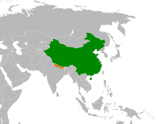
The China–Nepal border is the international boundary between the Tibet Autonomous Region of the People's Republic of China and Federal Democratic Republic of Nepal. It is 1,389 kilometres (863 mi) in length and runs in a northwest–southeast direction along the Himalayan mountain range, including Mount Everest, the world's highest mountain. The boundaries of this particular border have changed dramatically over time, especially when considering relatively recent events such as the Annexation of Tibet in 1949. However, some of the most significant developments of modern times would be the signing of the "Agreement on Maintaining Friendly Relations between the People’s Republic of China and the Kingdom of Nepal" in 1956 and the "Sino-Nepalese Treaty of Peace and Friendship" in 1960, both of which formally recognised Tibet as a part of China and confirmed the limits of the countries of China and Nepal as they are known today.

Korala or Kora La or Koro La {Nepali: (Nepali: कोरला]; literally Kora Pass} is a mountain pass between Tibet and Gandaki Province. At only 4,660 metres in elevation, it has been considered the lowest drivable path between Tibetan Plateau and the Indian subcontinent. It currently serves as a vehicle border crossing between China and Nepal. Korala in Mustang is the fourth border point that Beijing has reopened after the Rasuwa-Kerung, Tatopani-Khasa and Yari -Purang.
Kyirong or Gyirong , Jilong in Chinese and Kerung in Nepalese, is a town situated in the southern part of Gyirong County in the Tibet Autonomous Region, China. The town is situated on the east bank of Kyirong Tsangpo, a source stream of the Trishuli River, at an elevation of about 2,700 metres (8,900 ft). It has a subtropical mountain monsoon climate, with reasonable precipitation and warm weather, unusual for Tibet.

Rasuwa Fort or Rasuwa Gadhi is a historical fort ruin in the Rasuwa District of Nepal roughly at the border with Tibet, China. It is located along the Trishuli River 3 kilometres (1.9 mi) north of the Nepalese town of Timure in Langtang National Park, yet 25 km south of the nearest locality of China at Gyirong Town.
The China–Nepal Railway is a planned railway between China and Nepal. The railway will link Kathmandu with Shigatse, Tibet, crossing the China–Nepal border at Gyirong–Rasuwa.

The Tibet–Nepal salt trade route is an ancient salt trading route running between the Tibetan Plateau and the Middle Hills of Nepal and further on to India. After the annexation of Tibet by China in 1950 and the Sino-Indian War in 1962, patterns of trade changed and the use of the old trading route between India and Tibet dwindled and the salt-carrying caravans became redundant.