Nepal is a landlocked mountainous country where transportation is difficult due to the terrain.
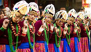
Gurung or Tamu are an ethnic group indigenous to the hills and mountains of Gandaki Province of Nepal. Gurung people predominantly live around the Annapurna region in Manang, Mustang, Dolpo, Kaski, Lamjung, Gorkha, Parbat,Tanahun and Syangja districts of Nepal. They are one of the main Gurkha tribes.

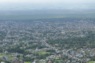
Biratnagar is a metropolitan city in Nepal, which serves as the capital of Koshi Province. With a Metropolitan Urban Agglomeration population of 244,750 as per the 2021 census, it is the largest city in the province and also the headquarters of Morang district. As per the preliminary report of 2022 Nepal census, Biratnagar Metropolitan has an estimated city population of 244,750. It is the administrative center of the Greater Birat Development Area which incorporates the cities of Biratnagar-Itahari-Gothgau-Biratchowk-Dharan primarily located on the Koshi Highway in Eastern Nepal, with an estimated total urban agglomerated population of 804,300 people in 159,332 households including the town of Ithari. Biratnagar is located 399 km (248 mi) east of the capital, Kathmandu, and 6 km (3.7 mi) north of the bordering town of Jogbani in the Indian state of Bihar.
Dharan is a sub-metropolitan city in Sunsari District of Koshi Province, in eastern Nepal, which was established as a fourth municipality in the Kingdom in 1958. It is the third most populous city in eastern Nepal after Biratnagar and Itahari. The Nepali word "dharan" means a saw pit. The rainforest from which the tree trunks came is still just on the edge of the city. Much later the British Gurkha camp opened in October 1960. The use of the camp by British Gurkhas finished in the mid-1990s. Dharan has an estimated city population of 173,096 living in 34,834 households as per the 2021 Nepal census. It is one of the cities of the Greater Birat Development Area which incorporates the cities of Biratnagar-Itahari-Gothgau-Biratchowk-Dharan primarily located on the Koshi Highway in Eastern Nepal, with an estimated total urban agglomerated population of 804,300 people living in 159,332 households. It is the largest city in the province number one by Area. It covers 192.32 square kilometers while Biratnagar and Itahari is 2nd and 3rd biggest cities by Area

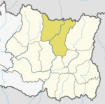
Sankhuwasabha District is one of 14 districts of Koshi Province of eastern Nepal. The district's area is 3,480 km2 with a population of 159,203 in 2001 and 158,742 in 2011. The administrative center is Khandbari.

Solukhumbu District (Nepali: सोलुखुम्बु जिल्ला, Sherpa: ཤར་ཁུམ་བུ་རྫོང་།, Wylie: shar khum bu dzong) is one of 14 districts of Koshi Province of eastern Nepal. As the name suggests, it consists of the sub-regions Solu and Khumbu. The closest post office to Solukhumbu with a postal code assigned to it is the Sindhuli D.P.O., which has the postal code 56000.

Taplejung District is one of 77 districts of Nepal and one of the 14 districts of Koshi Province. It is located deep in the Himalayas in Eastern Nepal with Tibet to the north across the Himalayas. Taplejung is the third largest district of Nepal.

Khandbari is the district headquarters of Sankhuwasabha District in Koshi Province of north-eastern Nepal.

Zhangmu or Dram in Tibetan, or Khasa in Nepali, is a customs town and port of entry located in Nyalam County in Tibet, China close to the Nepal-China border, just uphill and across the Bhote Koshi River from the Nepalese town of Kodari. At 2,300 metres (7,500 ft) above sea level, Zhangmu has mild and humid subtropical climate, which is a rarity for Tibet.
Chainpur is a municipality in Sankhuwasabha District in the Koshi Province of north-eastern Nepal. It was formed by merging five villages i.e. Chainpur, Siddhakali, Siddhapokhari, Baneshwar and Kharang. The municipality was implemented on 18 May 2014. At the time of the 1991 Nepal census it had a population of 4933 people in 948 households.

Olangchung Gola is a village in ward no. 7 of Phaktanglung rural municipality of Taplejung District of Province No. 1 in Nepal. Olangchung is surrounded by Lelep village to the east and Tibet to the north, Sankhuwasabha District to west and Mikkwakhola rural municipality to south. It is located to the north of Tamor River in the mountainous area in the northwest of Taplejung District bordering Tibet, China. Lately the river flowing next to the village is gradually expanding towards the village posing a serious threat of submerging the village.
Zhêntang Town, also known as Chentang, is a town in Dinggyê County, in the Shigatse prefecture-level city of the Tibet Autonomous Region of China. It is a border town on the China–Nepal border and lies on the Pum Qu River. At the time of the 2010 census, the town had a population of 2,043.As of 2013, it had 6 communities under its administration.

The China–Nepal border is the international boundary between the Tibet Autonomous Region of the People's Republic of China and Federal Democratic Republic of Nepal. It is 1,389 kilometres (863 mi) in length and runs in a northwest–southeast direction along the Himalayan mountain range, including Mount Everest, the world's highest mountain. The boundaries of this particular border have changed dramatically over time, especially when considering relatively recent events such as the Annexation of Tibet in 1949. However, some of the most significant developments of modern times would be the signing of the "Agreement on Maintaining Friendly Relations between the People’s Republic of China and the Kingdom of Nepal" in 1956 and the "Sino-Nepalese Treaty of Peace and Friendship" in 1960, both of which formally recognised Tibet as a part of China and confirmed the limits of the countries of China and Nepal as they are known today.

Koshi Province is the autonomous easternmost province adopted on 20 September 2015 by Constitution of Nepal. The province is rich in natural resources, tourist attractions, recreational activities, and natural beauty. The province covers an area of 25,905 km2 (10,002 sq mi), about 17.5% of the country's total area. With the industrial city of Biratnagar as its capital, the province includes major eastern towns of Birtamod, Sundar Haraincha, Damak, Dharan, Itahari, Triyuga Municipality and Mechinagar, and the Mount Everest, Kangchenjunga and Ama Dablam. Koshi River, the largest river of the nation, forms the province's western boundary. Under the First-past-the-post voting system issued by the Constituency Delimitation Commission, Nepal, the province hosts 28 parliamentary seats and 56 provincial assembly seats.

Madhesh Province is a province of Nepal in the Terai region with an area of 9,661 km2 (3,730 sq mi) covering about 6.5% of the country's total area. It has a population of 6,126,288 as per the 2021 Nepal census, making it Nepal's most densely populated province and the smallest province by area. It borders Koshi Pradesh to the east and the north, Bagmati Province to the north, and India’s Bihar state to the south and the west. The border between Chitwan National Park and Parsa National Park acts as the provincial boundary in the west, and the Kosi River forms the provincial border in the east. The province includes eight districts, from Parsa in the west to Saptari in the east.

Koshi Province is the easternmost province of Nepal. It is surrounded by Tibet region of China to the north, the Indian states of Sikkim and West Bengal to the east and Bihar to the south and Nepal's Bagmati and Madhesh provinces to the west.
Bhotkhola is a rural municipality (gaunpalika) out of five rural municipality located in Sankhuwasabha District of Koshi Province of Nepal. There are a total of 10 municipalities in Sankhuwasabha in which 5 are urban and 5 are rural.

Koshi Highway or H08 is a 390 km long planned highway located in Koshi Province. It is a north-south highway which is understood to be the shortest highway connecting India to China across the Himalayan mountains in Nepal. Rani at Biratnagar is the starting point of the road which is connected to Jogbani in India and Kimathanka is the end point of the Koshi Highway, which is connected to Chinese town Chentang.
The China–Nepal Railway is a planned railway between China and Nepal. The railway will link Kathmandu with Shigatse, Tibet, crossing the China–Nepal border at Gyirong–Rasuwa.

Koshi Province covers an area of 25,905 square kilometres (10,002 sq mi). It is located at easternmost part of Nepal bordering by Tibet Autonomous Region of China in north Bagmati Province in west, Province No. 2 in south-west, Bihar of India in south, North Bengal of India in south-east and Sikkim of India in north-east. Sikkim and part of North Bengal of India forms ethno-linguistic relation with Nepal. Geography of Koshi Province in eastern Nepal is very diverse, of highest peaks of Himalayas in northern extremes to terai region to south. It lies between 86 degree 1 minute and 88 degree 3 minutes east longitude and 28 degree 2 minutes and 26 degree 3 minutes north longitude. Biratnagar, the industrial capital of Nepal, is the temporary capital of this province.