Khandbari Municipality

Last updated
Khandbari
खाँदवारी नगरपालिका
View from the hotel in Khadbari (9270480218).jpg
Nepal adm location map.svg
Red pog.svg
Khandbari
Location in Nepal
Coordinates: 27°22′N87°13′E / 27.367°N 87.217°E / 27.367; 87.217
CountryFlag of Nepal.svg    Nepal
Province Koshi Province
District Sankhuwasabha District
Government
   Mayor Mahesh Thapaliya (NC)
   Deputy Mayor Maheshwara Bajracharya (CPN (UML))
Population
 (2011)
  Total26,301
Time zone UTC+5:45 (NST)
Postal code
56900
Area code 029
Website khandbarimun.gov.np

Khandbari is the district headquarters of Sankhuwasabha District in Koshi Province of north-eastern Nepal.

Contents

Demographics

At the time of the 2011 Nepal census, Khandbari Municipality had a population of 31,534. Of these, 68.7% spoke Nepali, 5.5% Lohorung, 4.1% Tamang, 3.5% Sherpa, 3.1% Rai, 2.9% Kulung, 2.8% Magar, 2.1% Newar, 1.7% Gurung, 0.8% Yamphu, 0.4% Thulung, 0.3% Khaling, 0.3% Koi, 0.3% Limbu, 0.3% Maithili, 0.2% Bantawa, 0.2% Bhujel, 0.2% Chamling, 0.2% Dumi, 0.2% Kulung, 0.2% Majhi, 0.2% Mewahang, 0.2% Nachhiring, 0.2% Yakkha, 0.1% Bahing, 0.1% Bote, 0.1% Lhomi, 0.1% Sampang, 0.1% Tharu and 0.8% other languages as their first language. [1]

In terms of ethnicity/caste, 19.4% were Chhetri, 18.2% Rai, 9.1% Newar, 7.9% Hill Brahmin, 7.5% Gurung, 7.2% Kami, 6.9% Tamang, 5.3% Magar, 3.1% Sherpa, 2.9% Damai/Dholi, 2.8% Kumal, 1.9% Sarki, 1.3% Kulung, 0.8% Limbu, 0.7% Bhote, 0.7% Sanyasi/Dasnami, 0.6% Gharti/Bhujel, 0.5% Lohorung, 0.5% Majhi, 0.3% Yakkha, 0.2% Thakuri, 0.1% Badi, 0.1% Bote, 0.1% Chamling, 0.1% Ghale, 0.1% Hajjam/Thakur, 0.1% Khaling, 0.1% Khawas, 0.1% Lhomi, 0.1% Marwadi, 0.1% Mewahang Bala, 0.1% Musalman, 0.1% Pattharkatta/Kushwadiya, 0.1% Samgpang, 0.1% Tharu, 0.1% Yadav, 0.1% Yamphu and 0.6% others. [2]

In terms of religion, 62.3% were Hindu, 20.8% Buddhist, 14.5% Kirati, 1.4% Christian, 0.3% Prakriti, 0.1% Jain, 0.1% Muslim and 0.5% others. [3]

In terms of literacy, 73.8% could read and write, 2.6% could only read and 23.6% could neither read nor write. [4]

The area

A road connects Khandbari directly south to Biratnagar and the Terai. Khandbari will be soon connected with Kimmathanka and Tibet. Khandbari is fastest growing city and most developed among Hilly Region. It has established itself as a trading center for people of sankhuwasabha and some parts of Bhojpur districts.[ citation needed ]

Khandbari's reputed schools include Himalayan Higher secondary school ,Barun Secondary English School, Surya Higher Secondary Boarding School, Bagishwari Secondary School, Makalu English Boarding School and Sunshine English Secondary Boarding School.[ citation needed ]

Arun III Hydropower project is located nearby. Arun III Hydropower project is one of the major subjects that really matters to the residents.[ citation needed ]

About 3 km (1.9 mi) north from Khandbari lies another small bazaar known as Manebhanjyang which is an emerging business centre peak in the world.[ citation needed ]

A road has already been constructed that connects Khandbari directly to Biratnagar. Its border districts are Bhojpur, Solukhumbu, Taplejung, Terhathum and Dhankuta. The change in the political situation in the country has given much hope for the residents of the district for its rapid development.[ citation needed ]

The hospital in Khandbari is described as "comparatively well-equipped", and has received patients from surrounding areas arriving on foot or road and by chartered helicopters. [5]

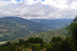
Khandbari is the main departure point for trekking to Mount Makalu (8463 meters), 5th highest peak in the world [ citation needed ] and Makalu Barun National Park.Arun valley which is the deepest valley in the world is located here with an elevation of 435 meters (1,427 ft) from sea level.It is also famous among tourists because it is home to more than 800 different species of butterflies and over 650 species of birds. Among them one can also see spiny Babbler which is a species of bird only found in middle hills of Nepal.

People can reach Khandbari by road and air transport.There are number of public Buses connecting khandbari with Dharan which is around 6 hours drive and also there are direct buses from Kathmandu to khandbari. Air transport is provided through Tumlingtar Airport, which lies on the bank of Arun river. Every day, there are flights from Kathmandu and Biratnagar. The main town of khandbari is 13 km (8.1 mi) from the airport and can be reached by jeep, auto and van in around 20 minutes.

Media

To promote local culture, Khandbari has five FM radio stations:

Related Research Articles

<span class="mw-page-title-main">Dhankuta</span> City in Koshi Province, Nepal

Dhankuta is a hill town and the headquarters of Dhankuta District in Koshi Province in Eastern Nepal. According to 2011 Nepal census, it has population of 26,440 inhabitants.

<span class="mw-page-title-main">Biratnagar</span> Capital of Koshi province

Biratnagar is a metropolitan city in Nepal, which serves as the capital of Koshi Province. With a Metropolitan Urban Agglomeration population of 756,000 as per the 2022 census, it is the largest city in the province and also the headquarters of Morang district. As per the preliminary report of 2022 Nepal census, Biratnagar Metropolitan has an estimated city population of 756,000, including the population of connected towns like Katahari, Tankisinuari, etc. It is the administrative center of the Greater Birat Development Area which incorporates the cities of Biratnagar-Itahari-Gothgau-Biratchowk-Dharan primarily located on the Koshi Highway in Eastern Nepal, with an estimated total urban agglomerated population of 804,300 people living in 159,332 households including town of Ithari. Biratnagar is located 399 km (248 mi) east of the capital, Kathmandu, and 6 km (3.7 mi) north of the bordering town of Jogbani in the Indian state of Bihar.

<span class="mw-page-title-main">Bhojpur District, Nepal</span> District in Koshi Province, Nepal

Bhojpur District is one of 14 districts of Koshi Province of eastern Nepal. The district's area is 1,507 km2 with a population of 182,459 (2011). The administrative center is Bhojpur. It is surrounded by Dhankuta and Sankhuwasabha in the east, Khotang in the west, again Sankhuwasabha in north-east and Solukhumbu in the north-west and Udayapur in the South.

<span class="mw-page-title-main">Dhankuta District</span> District in Koshi Province, Nepal

Dhankuta District is one of 14 districts of Koshi Province of eastern Nepal. The district covers an area of 891 km2 (344 sq mi) and has a population (2011) of 163,412. Dhankuta is the district headquarters of Dhankuta District.

<span class="mw-page-title-main">Ilam District</span> District in Koshi Province, Nepal

Ilam district is one of 14 districts of Koshi Province of eastern Nepal. It is a Hill district and covers 1,703 km2 (658 sq mi). The 2011 census counted 290,254 population. The municipality of Ilam is the district headquarters and is about 600 km (370 mi) from Kathmandu.

<span class="mw-page-title-main">Morang District</span> District in Nepal

Morang District is located in Koshi Province in eastern Nepal. It is an Outer Terai district. It borders Jhapa to the east, Dhankuta and Panchthar to the north, Sunsari to the west, and Bihar, India, to the south. Morang has one metropolitan city (Biratnagar), eight municipalities and eight rural municipalities. The total area of Morang is 1,855 km2 (716 sq mi). The lowest elevation point is 60 meters and the highest is 2,410 meters above sea level. The headquarters of Morang is connected by the Koshi National Highway to the east–west Mahendra National Highway at Itahari, Sunsari. Morang is also connected to the Hill parts of the eastern region of Nepal. Morang is the core industrial sector for the eastern region of Nepal.

<span class="mw-page-title-main">Sankhuwasabha District</span> District in Koshi Province, Nepal

Sankhuwasabha District is one of 14 districts of Koshi Province of eastern Nepal. The district's area is 3,480 km2 with a population of 159,203 in 2001 and 158,742 in 2011. The administrative center is Khandbari.

<span class="mw-page-title-main">Tehrathum District</span> District in Koshi Province, Nepal

Tehrathum District, is one of 14 districts of Koshi Province of Nepal.

<span class="mw-page-title-main">Sakela</span> One of the main festival of Kirat Rai people

Sakela is one of the main festival of Kirat Rai people, an ethnic group indigenous to Eastern Nepal and Sikkim, Kalimpong, and Darjeeling regions of India. Sakela is celebrated twice a year and is distinguished by two names Ubhauli and Udhauli. Sakela Ubhauli is celebrated during Baisakh Purnima and Sakela Udhauli is celebrated during the full moon day in the month of Mangsir.

Chainpur is a municipality in Sankhuwasabha District in the Koshi Province of north-eastern Nepal. It was formed by merging five villages i.e. Chainpur, Siddhakali, Siddhapokhari, Baneshwar and Kharang. The municipality was implemented on 18 May 2014. At the time of the 1991 Nepal census it had a population of 4933 people in 948 households.

The Kiranti languages are a major family of Sino-Tibetan languages spoken in Nepal and India by the Kirati people.

<span class="mw-page-title-main">Nwagi festival</span>

Nwagi, also spelled Nuwagi or Udhauli, is a major festival celebrated the by Rai people and also other Kirati ethnic community. Nuwagi also call by Rai sub-groups: "Nagi or Dedam" in Kulung, "Chowaa" in Chamling " Chhachhuwa" in Bantawa, "Nuwagi or Khamang" in Lohorung, Yamphu and Mewahang languages.

Panchkhapan (Nepali: पाँचखप्पन) is an urban municipality out of five urban municipalities of Sankhuwasabha District in Koshi Province of Nepal. It lies on 87°12'12" E to 87°26'45" E Longitude and 27°17'37.4" N to 27°24'38" N Latitude. The municipality was established on 3 March 2017 merging former VDCs: Syabun, Jaljala and Wana. The area of the municipality is 148.03KM2 and according to 2011 census of Nepal the population of the municipality is 17,521.

Madi is a municipality in Sankhuwasabha District of Koshi Province in Nepal. It is a municipality out of 5 municipalities in Sankhuwasabha District. Total area of the municipality is 110.10 km (68.41 mi) and according to 2011 census of Nepal, the population of this municipality is 14,470. The municipality was established in March 2017 merging some former VDCs: e.g. Madi Mulkharka, Madi Rambeni and Mawadin. The municipality is divided into 13 wards. The headquarter of the municipality is in Okharbote.

Sangurigadhi is a rural municipality (gaunpalika) out of four rural municipality located in Dhankuta District of Koshi Province of Nepal. There are a total of 7 municipalities in Dhankuta in which 3 are urban and 4 are rural.

Chaubise is a rural municipality (gaunpalika) out of four rural municipality located in Dhankuta District of the Koshi Province of Nepal. There are a total of 7 municipalities in Dhankuta in which 3 are urban and 4 are rural.

Buddhashanti is a rural municipality (gaunpalika) out of seven rural municipality located in Jhapa District of Koshi Province of Nepal. Buddhashanti, according to Ministry of Federal Affairs and Local Development has an area of 79.78 square kilometres (30.80 sq mi) and the total population of the municipality is 41,615 as of Census of Nepal 2011.

Makalu is a rural municipality (gaunpalika) out of five rural municipality located in Sankhuwasabha District of Koshi Province of Nepal. There are a total of 10 municipalities in Sankhuwasabha in which 5 are urban and 5 are rural.

Chichila is a rural municipality (gaunpalika) out of five rural municipality located in Sankhuwasabha District of Koshi Province of Nepal. There are a total of 10 municipalities in Sankhuwasabha in which 5 are urban and 5 are rural.

Bhotkhola is a rural municipality (gaunpalika) out of five rural municipality located in Sankhuwasabha District of Koshi Province of Nepal. There are a total of 10 municipalities in Sankhuwasabha in which 5 are urban and 5 are rural.

References

  1. NepalMap Language
  2. NepalMap Caste
  3. NepalMap Religion
  4. NepalMap Literacy
  5. "Sole staffer deserts health post". The Kathmandu Post. 2014-07-09. Retrieved 2014-07-10.

See also