
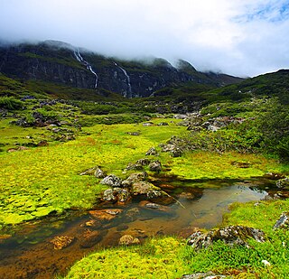
Kangchenjunga, also spelled Kanchenjunga, Kanchanjanghā and Khangchendzonga, is the third-highest mountain in the world. Its summit lies at 8,586 m (28,169 ft) in a section of the Himalayas, the Kangchenjunga Himal, which is bounded in the west by the Tamur River, in the north by the Lhonak River and Jongsang La, and in the east by the Teesta River. It lies in the border region between Nepal and Sikkim state of India, with three of the five peaks, namely Main, Central and South, directly on the border, and the peaks West and Kangbachen in Nepal's Taplejung District.

Nepal measures about 880 kilometers (547 mi) along its Himalayan axis by 150 to 250 kilometers across. It has an area of 147,516 km2 (56,956 sq mi).

Dudh Koshi is a river in eastern Nepal. It is the highest river in terms of elevation.
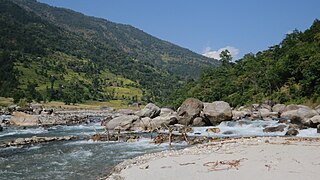
The Tamor River is a major river in eastern Nepal, which begins around Kanchenjunga. The Tamor and the Arun join the Sun Koshi at Tribenighat to form the giant Saptakoshi which flows through Mahabharat Range on to the Gangetic plain.

The Gandaki River, also known as the Narayani and the Gandak, is one of the major rivers in Nepal and a left bank tributary of the Ganges in India. Its total catchment area amounts to 46,300 km2 (17,900 sq mi), most of it in Nepal. In the Nepal Himalayas, it is notable for its deep canyon. The basin also contains three mountains over 8,000 m (26,000 ft), namely Dhaulagiri, Manaslu and Annapurna I. Dhaulagiri is the highest point of the Gandaki basin.

Kosi or Koshi was one of the fourteen zones of Nepal until the restructure of zones to provinces. The headquarters of Kosi Zone was Biratnagar which was also its largest city. Other cities of Kosi Zone were Inaruwa, Dharan, Dhankuta, Jhumka, Duhabi, Tarahara and Itahari. Its main rivers were Arun, Tamor and Sapta Koshi.

The Kosi or Koshi is a transboundary river which flows through China, Nepal and India. It drains the northern slopes of the Himalayas in Tibet and the southern slopes in Nepal. From a major confluence of tributaries north of the Chatra Gorge onwards, the Kosi River is also known as Saptakoshi for its seven upper tributaries. These include the Tamur River originating from the Kanchenjunga area in the east and Arun River and Sun Kosi from Tibet. The Sun Koshi's tributaries from east to west are Dudh Koshi, Likhu Khola, Tamakoshi River, Bhote Koshi, and Indravati. The Saptakoshi crosses into northern Bihar, India where it branches into distributaries before joining the Ganges near Kursela in Katihar district. Kosi is the 3rd largest tributary of the Ganges by water discharge after Ghaghra and Yamuna.
Bhote Koshi in Nepal and Poiqu in Tibet, both names roughly mean "Tibetan river," is the name given to the upper course of the Sun Kosi river. It is part of the Koshi River system in Nepal.

The Arun River is a trans-boundary river and is part of the Kosi or Sapt Koshi river system in Nepal. It originates in Tibet Autonomous Region of the People's Republic of China where it is called the Phung Chu or Bum-chu.
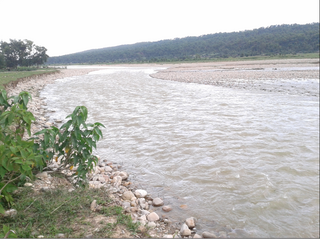
The 2008 Bihar flood was one of the most disastrous floods in the history of Bihar, an impoverished and densely populated state in India. The Koshi embankment near the Indo-Nepal border broke on 18 August 2008. The river changed course and flooded areas which had not been flooded in many decades. The flood affected over 2.3 million people in the northern part of Bihar.
Bihar is India's most flood-prone state, with 76% of population in the North Bihar living under the recurring threat of flood devastation. Bihar makes up 16.5% of India's flood affected area and 22.1% of India's flood affected population. About 73.06% of Bihar's geographical area, i.e. 68,800 square kilometres (26,600 sq mi) out of 94,160 square kilometres (36,360 sq mi), is flood affected. On an annual basis, they destroy thousands of human lives apart from livestock and assets worth millions. In total, they have claimed 9,500 lives since the government started publishing figures in 1979. North Bihar districts are vulnerable to at least five major flood-causing rivers during monsoon – Mahananda River, Koshi River, Bagmati River, Burhi Gandak River and Gandak – which originate in Nepal. Some south Bihar districts have also become vulnerable to floods from Son, Punpun and Phalgu rivers. The 2013 flood affected over 5.9 million people in 3,768 villages in 20 districts of the state. 2017 flood affected 19 districts of North Bihar killing 514 people and affecting 1.71 crore people.
The Kamala River originates from Nepal and flows through Indian state of Bihar.

The Indravati River in Nepal is a tributary of the Sun Koshi River. It used to be called "Melamchi" or "Melamchu" until the 19th century.
The Barun River is a tributary of the Arun River and is part of the Kosi river system in Nepal.

The Trishuli River is one of the major tributaries of the Narayani River basin in central Nepal. The river is formed by the merger of Kyirong Tsangpo and Lende Khola originating in Gyirong County of Tibet, which join together near the Rasuwa Gadhi on the Nepal–Tibet border. The valley of the river provided the traditional trade route between the Kathmandu Valley and Tibet.

The Sunkoshi, also spelt Sunkosi, is a river of Nepal that is part of the Koshi or Saptkoshi River system in Nepal. Sunkoshi has two source streams, one that arises within Nepal in Choukati, and the other more significant stream that flows in from Nyalam County in the Tibet region of China. The latter is called Bhote Koshi in Nepal and Matsang Tsangpo in Tibet. Due to the significant flows from Bhote Koshi, the Sun Koshi river basin is often regarded as a trans-border river basin.

Koshi Province is the autonomous easternmost province adopted on 20 September 2015 by Constitution of Nepal. The province is rich in natural resources, tourist attractions, recreational activities, and natural beauty. The province covers an area of 25,905 km2, about 17.5% of the country's total area. With the industrial city of Biratnagar as its capital, the province covers other major eastern towns including Birtamod, Birat Chowk, Damak, Dharan, Itahari, Triyuga and Mechinagar and includes several mountains including the Everest, Kangchenjunga, and Ama Dablam. Koshi River, the largest river of the nation, is the province's western boundary. Understanding of the first-past-the-post voting system issued by the Constituency Delimitation Commission, Nepal, the province hosts 28 parliamentary seats and 56 provincial assembly seats.
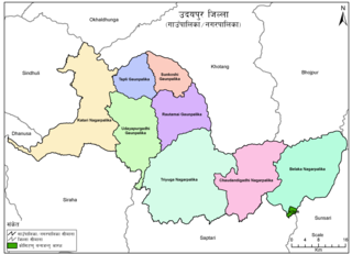
Belaka is a municipality located in Udayapur District of Province No. 1 of Nepal. It is one of four urban municipalities located in Udayapur District.
Saptakosi High Dam, also called Koshi High Dam, is a multipurpose project proposed to be constructed on the Saptakoshi River of Nepal. The project is primarily aimed to control floods in south-east Nepal and northern Bihar of India, and to generate hydro power. An issue subsequently coming with this project is Nepal’s access to sea port via 165 km long navigation canal linking to Calcutta sea port through River Ganges.

The Government of Koshi, known locally as the Provincial Government, is the supreme governing authority of the Koshi Province which consists of 14 districts.
