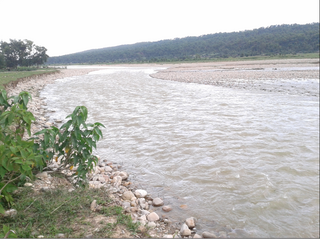
The Ghaghara River, also known as the Karnali River in Nepal, Mapcha Tsangpo in Tibet, and the lower Ghaghara in Awadh is known as the Sarayu River, is a perennial trans-boundary river that originates in the northern slopes of the Himalayas in the Tibetan Plateau, cuts through the Himalayas in Nepal and joins the Sharda River at Brahmaghat in India. Together they form the Ghaghara River, a major left-bank tributary of the Ganges. With a length of 507 km (315 mi), it is the longest river in Nepal. The total length of the Ghaghara up to its confluence with the Ganges at Revelganj in Bihar is 1,080 km (670 mi). It is the largest tributary of the Ganges by volume and the second largest by length after Yamuna.

Purnia is the fourth largest city of Bihar and is emerging as the largest economic hub in North Bihar. It serves as the administrative headquarters of both Purnia district and Purnia division in the Indian state of Bihar. It is well known for its favourable climate like Darjeeling and has an abundance of resources for human settlements and economic activities.

Damodar River is a river flowing across the Indian states of Jharkhand and West Bengal. The valley is rich in mineral resources and is known for large-scale mining and industrial activity. It was also known as the Sorrow of Bengal because of the ravaging floods it caused in the plains of West Bengal. The construction of several dams on the Damodar and its tributaries has helped control some of the flooding.

The Mahananda is a trans-boundary river that flows through the Indian states of Bihar and West Bengal before crossing into Bangladesh. It is an important tributary of the Ganges.

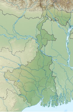
The Ganges Basin is a major part of the Ganges-Brahmaputra-Meghna (GBM) basin draining 1,999,000 square kilometres in Tibet, Nepal, India and Bangladesh. To the north, the Himalaya or lower parallel ranges beyond form the Ganges-Brahmaputra divide. On the west the Ganges Basin borders the Indus basin and then the Aravalli ridge. Southern limits are the Vindhyas and Chota Nagpur Plateau. On the east the Ganges merges with the Brahmaputra through a complex system of common distributaries into the Bay of Bengal. Its catchment lies in the states of Uttar Pradesh (294,364 km2), Madhya Pradesh (198,962 km2), Bihar (143,961 km2), Rajasthan (112,490 km2), West Bengal (71,485 km2), Haryana (34,341 km2), Himachal Pradesh (4,317 km2), Delhi, Arunachal Pradesh (1,484 km2), the whole of Bangladesh, Nepal and Bhutan. Several tributaries rise inside Tibet before flowing south through Nepal. The basin has a population of more than 500 million, making it the most populated river basin in the world.

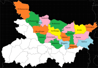
Purnia District is one of the thirty-eight districts of the Indian state of Bihar. The city of Purnia is the administrative headquarters of this district. The city of Purnia has continued its tradition of hoisting the national flag at 12:07 am on every Independence Day since 1947. Purnia district is a part of Purnia Division. The district extends northwards from the Ganges river.
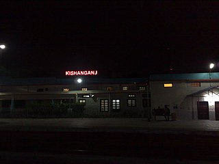
Kishanganj district is one of the thirty-eight districts of Bihar state, India, and Kishanganj town is the administrative headquarters of this district. Kishanganj district is a part of Purnia division (Seemanchal).

The Kosi or Koshi is a transboundary river which flows through China, Nepal and India. It drains the northern slopes of the Himalayas in Tibet and the southern slopes in Nepal. From a major confluence of tributaries north of the Chatra Gorge onwards, the Kosi River is also known as the Saptakoshi for its seven upper tributaries. These include the Tamur River originating from the Kanchenjunga area in the east and Arun River and the Sun Kosi from Tibet. The Sun Koshi's tributaries from east to west are the Dudh Koshi, Likhu Khola, Tamakoshi River, Bhote Koshi and Indravati. The Saptakoshi crosses into northern Bihar, India where it branches into distributaries before joining the Ganges near Kursela in Katihar district. The Kosi is the third-largest tributary of the Ganges by water discharge after the Ghaghara and the Yamuna.

The Baitarani is one of six major rivers of Odisha, India. Venerated in popular epics and legends, the Baitarani River is a source of water for agricultural irrigation. The coastal plain of Odisha has the name of "Hexadeltaic region" or the "Gift of Six Rivers". These deltas divide the coastal plain into three regions from north to south. The Baitarani, the Mahanadi and the Brahmani rivers form the Middle Coastal Plain, with evidence of past "back bays" and present lakes.
The Mayurakshi is a major river in Jharkhand and West Bengal, India, with a long history of devastating floods.
Bihar is recognized as India's most flood-prone state, with approximately 76% of the population in North Bihar living under the persistent threat of severe flooding. Bihar makes up 16.5% of India's flood-affected area and contains 22.1% of India's flood-affected population. About 73.06% of Bihar's geographical area, 68,800 square kilometres (26,600 sq mi) out of 94,160 square kilometres (36,360 sq mi), is affected. Each year, floods kill many and damage livestock and other assets worth millions. In total, floods have claimed 9,500 lives since the government started publishing figures in 1979. North Bihar districts are vulnerable to at least five major flood-causing rivers during monsoon – the Mahananda, Koshi, Bagmati, Burhi Gandak, and Gandak rivers – which originate in Nepal. Some South Bihar districts have also become vulnerable to floods, from the Son, Punpun, and Phalgu rivers. The 2013 flood affected over 5.9 million people in 3,768 villages in 20 districts in the state. The 2017 flood affected 19 districts in North Bihar, killing 514 people and affecting over 17 million.

The Punpun River is a tributary of the Ganges. It originates in Palamu district of Jharkhand and flows through Chatra, Gaya, Jehanabad and Patna districts of the Indian states of Jharkhand and Bihar. Punpun is a place named after the Punpun river in Patna which is situated on the bank of Punpun river. On the bank of Punpun people celebrate Chhath Puja.
The Kamala River originates in Nepal and flows through the Indian state of Bihar.
The Kankai River is a trans-boundary river flowing through the hills of Ilam and the plains of the Jhapa District in Nepal. It begins at the confluence of the Mai Khola and Deb Mai Khola rivers.

Mirik is a community development block that forms an administrative division in the Mirik subdivision of the Darjeeling district in the Indian state of West Bengal.
North Bihar is a term used for the region of Bihar, India, which lies north of the Ganga river.
Thakurganj railway station serves Thakurganj town in Kishanganj district in the Indian state of Bihar. The Mechi flowing nearby forms the boundary between Nepal and India in the area. On the other side of the border lies Prithivinagar town of Nepal.

The India–Nepal border is an open international boundary running between the republics of India and Nepal. The 1,751 km (1,088.02 mi) long border includes the Himalayan territories as well as Indo-Gangetic Plain of the subcontinent. The current border was delimited after the Sugauli treaty of 1816 between Nepal and the British Raj. Following Indian independence, the prevailing border was recognised as the international border between the Kingdom of Nepal and the Dominion of India.

Batashi is a village in Kharibari CD block in Siliguri subdivision of Darjeeling district of West Bengal, India.