Howrah is a metropolitan city and a municipal corporation of Howrah district in the Indian state of West Bengal. It is the headquarter of the Howrah Sadar subdivision. Howrah is located on the western bank of the Hooghly River. It is a part of the area covered by Kolkata Metropolitan Development Authority (KMDA). Howrah is an important transportation hub of West Bengal and a major gateway for its twin city of Kolkata.
Saraighat is a neighborhood in the Indian city of Guwahati, on the north bank of the river Brahmaputra. Sarai was a small village where the old abandoned N.F. Railway station of Amingaon was located. The famous Battle of Saraighat was fought near this place on the river in 1671.

Mahatma Gandhi Setu is a bridge over the river Ganges in Bihar, India, connecting Patna in the south to Hajipur in the north. Its length is 5,750 metres (18,860 ft) and it is the third-longest river bridge in India. It was inaugurated in May 1982 in a ceremony in Hajipur by the then prime minister, Indira Gandhi.

Rohtas district is one of the thirty-eight districts of Bihar state, India. It came into existence when Shahabad District was bifurcated into Bhojpur & Rohtas in 1972.

Vikramshila Setu is a bridge across the Ganges, near Bhagalpur in the Indian state of Bihar named after the ancient Mahavihara of Vikramashila which was established by King Dharmapala.

Vidyasagar Setu, also known as the Second Hooghly Bridge, is a toll bridge over the Hooghly River in West Bengal, India, linking the cities of Kolkata and Howrah.

Rajendra Setu is a bridge across the River Ganges that was the first bridge to link the northern and southern portions of the state of Bihar. The location of the bridge was based on the work of M. Visvesvaraya, who was more than 90 years old at the time.
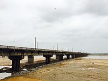
The Digha–Sonpur rail–road bridge or J.P Setu is a bridge across river Ganga, connecting Digha Ghat in Patna and Pahleja Ghat in Sonpur, Saran district in the Indian state of Bihar. The rail-cum-road bridge provides easy roadway and railway link between northern and southern parts of Bihar. It is a steel truss bridge. Regular scheduled passenger rail service was inaugurated on this route on 3 February 2016. This bridge of 4,556 metres (14,948 ft) length is the second longest rail-cum-road bridge in India, after Bogibeel Bridge in Assam. This is second railway bridge in Bihar after Rajendra Setu that connects North Bihar to South Bihar. Indian railways has constructed two railway stations on either sides of the bridge – Patliputra Junction railway station (PPTA) and Bharpura Pahleja Ghat Junction railway station (PHLG). The distance between the Digha-Sonpur bridge and Digha Bridge Halt(DGBH) is around 2 km.

Srikrishna Setu Munger Ganga Bridge, is a rail-cum-road bridge across the Ganges, at Munger in the Indian state of Bihar. The bridge connects Munger District Munger-Jamalpur twin cities to various districts of North Bihar. Srikrishna Setu Munger Ganga Bridge is the third rail-cum-road bridge over Ganga in Bihar.
The Gaya–Mughalsarai section is a railway line connecting Gaya and Mughalsarai. This 197-kilometre (122 mi) track is part of the Grand Chord, Howrah-Gaya-Delhi line and Howrah-Allahabad-Mumbai line. This section includes Arrah-Sasaram and Son Nagar branch lines. It is under the jurisdiction of East Central Railway.
The New Bongaigaon–Guwahati section of the Barauni–Guwahati line connects New Bongagaon and Guwahati in the Indian state of Assam.
The Barauni–Guwahati Railway line connects Barauni, Saharsa, Purnia and katihar in the Indian state of Bihar and Guwahati in Assam. It is a linkage of prime importance for Northeastern India.

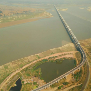
Bogibeel bridge is a combined road and rail bridge over the Brahmaputra river in the north eastern Indian state of Assam between Dhemaji district and Dibrugarh district, which was started in the year 2002 and took a total of 200 months to complete, heavy rainfall in the region being the main cause for the slow progress. Bogibeel river bridge is the longest rail-cum-road bridge in India measuring 4.94 kilometres over the Brahmaputra river. As it is situated in an earthquake-prone area it is India's first bridge to have fully welded steel-concrete support beams that can withstand earthquakes of magnitudes up to 7 on the Richter Scale. It is Asia’s 2nd longest rail-cum-road bridge and has a serviceable period of around 120 years. It is the 5th longest bridge in India after Bhupen Hazarika Setu, Dibang River Bridge, Mahatma Gandhi Setu and Bandra-Worli Sea Link. The bridge was constructed by a consortium of construction companies headed by Hindustan Construction Company. The bridge has a double rail line on the lower deck and a 3 lane road on the upper deck.
The state of Bihar has a number of bridges, extending from few meters to a few kilometers. The history of long bridges goes back to the British Empire when the site for the Koilvar bridge( now called Abdul Bari) was surveyed in 1851. Since then a number of small and large bridges have crept up. Some are even largest of their kind. Gandhi Setu, joining Patna and Hajipur is Asia's second longest river bridge.

Arrah–Chhapra Bridge or Veer Kunwar Singh Setu is the longest multi-span Extradosed bridge in the world across the Ganges river connecting Arrah and Chhapra in Bhojpur and Saran districts in the Indian state of Bihar. The second longest Extradosed bridge is Kisi Gawa bridge in Japan which is 275m long. The bridge provides a roadway link between the northern and southern parts of Bihar. Veer Kunwar Singh bridge was opened for public use on 11 June 2017.

The Dhola–Sadiya Bridge, also referred to as the Bhupen Hazarika Setu, is a beam bridge in India, connecting the northeast states of Assam and Arunachal Pradesh. The bridge spans the Lohit River, a major tributary of the Brahmaputra River, from the village of Dhola in the south to Sadiya to the north. The bridge is the first permanent road connection between the northern Assam and eastern Arunachal Pradesh.