
Sone River, also spelt Son River, is a perennial river located in central India. It originates near Amarkantak Hill in Pendra, Chhattisgarh and finally merges with the Ganga river near Maner in Patna, Bihar. The Sone River is the second-largest southern tributary of the Ganges after the Yamuna River. India's oldest river bridge Koilwar Bridge over Sone River connects Arrah with Patna. Sone river is famous for its sand across country. Multiple dam(s) and hydro-electric projects run on its course towards Ganges.
Sonbhadra or Sonanchal is the second largest district by area of Uttar Pradesh after Lakhimpur Kheri. The district headquarters is in the town of Robertsganj. Sonbhadra is also known as the "Energy Capital of India" because there are multiple power plants.

Mirzapur division, also sometimes known as Vindhyachal division, is one of the 18 administrative geographical units of the northern Indian state of Uttar Pradesh. Mirzapur city is the administrative headquarters. Currently, the division consists of 3 districts:-
Surguja district is a district of the Indian state of Chhattisgarh. The district is one of the oldest districts of Chhattisgarh. The headquarters of the district is Ambikapur.

Surajpur is a Nagar Palika Parishad situated in the bank of Rihand River in Surajpur district of Chhattisgarh state in Central India. It is the administrative headquarters of the Surajpur district, located 334 km away from the state's capital city, Raipur. National Highway 43 passes through Surajpur.

Robertsganj also known as Sonbhadra City is a city and a municipal board in Sonbhadra district in the Indian state of Uttar Pradesh.
Pipri is a town and a nagar panchayat in Sonbhadra district in the Indian state of Uttar Pradesh.

Renukoot is a town and a nagar panchayat in Sonbhadra district in the Indian state of Uttar Pradesh. It is 68 km south from the district headquarters Robertsganj.

Singrauli district is one of the districts in the Indian state of Madhya Pradesh.
Shaktinagar is a small town in Sonbhadra, Mirzapur Division, Uttar Pradesh near Varanasi, India. The city borders with Madhya Pradesh at Jayant Border.
Rihand Dam also known as Govind Ballabh Pant Sagar, is the second largest dam of India by volume (storage) next only to Indirasagar Dam of Madhya Pradesh. The reservoir of Rihand Dam is called Govind Ballabh Pant Sagar and is India's largest artificial lake. Rihand Dam is a concrete gravity dam located at Pipri in Sonbhadra District in Uttar Pradesh, India. Its reservoir area is on the border of Madhya Pradesh and Uttar Pradesh. It is located on the Rihand River, a tributary of the Son River. The catchment area of this dam extends over Uttar Pradesh, Madhya Pradesh & Chhattisgarh whereas it supplies irrigation water in Bihar located downstream of the river.
The DIGALRiver is a tributary of the Son River and flows through the India states of Chhattisgarh, Jharkhand and Uttar Pradesh.
Rihand Nagar is a township, named after the Rihand River, a tributary of the Sone River. It is located near Bijpur and lies in the Sonebhadra district of Uttar Pradesh. This township is situated near the border of Uttar Pradesh and Madhya Pradesh in India. This township has been developed by National Thermal Power Corporation (NTPC) under its Power Project Scheme, wherein it established a coal-based power station of 3000 MW capacity.

Rihand Super Thermal Power Project is located at Renukut, Sonebhadra in Sonbhadra district in Indian state of Uttar Pradesh. The power plant is one of the coal based power plants of NTPC Limited.
Muirpur Airport also spelled as Myorpur Airport is an upcoming airport, situated at Myorpur approx 12 km (7.5 mi) from the Renukut in the Sonbhadra district in the Indian state of Uttar Pradesh. Airport is developing by upgrading the existing government airstrip. It serves nearby towns, Northern Coalfields Limited (NCL), NTPC projects Renukut and Robertsganj, the Other towns of Sonbhadra and Singrauli district of Madhya Pradesh. Balrampur-Ramanujganj district of Chhattisgarh and Garhwa district of Jharkhand. The airport serves the region which has many electrical power stations, known as the "Energy Capital of India". It is 26.5 km (16.5 mi) away from DUDHI TEHSIL. The proposed airport will boost the power sector of the nation and more investment will be made in the power sector internationally. This Airport will be connected to a nearby railway and bus station.
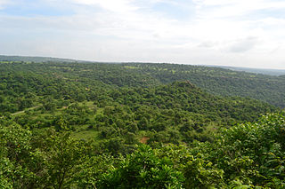
Surajpur district is a district in the state of Chhattisgarh in central India, with its administrative headquarters at Surajpur. National Highway 43 passes through Surajpur district. Surajpur was declared a district on 15 August 2011 along with eight other new districts. Surajpur is the first district to receive National Satyan Maitra Literacy Award. The district is known for its market and other major tourist places of Chhattisgarh with Tamor Pingla Wildlife Sanctuary.

Balrampur-Ramanujganj district is a district in the Indian state of Chhattisgarh. It came into existence on 17 January 2012 and was formerly part of Surguja district. Balrampur-Ramanujganj district is the northernmost district of Chhattisgarh. Its seat is Balrampur.

Madhupur is a census town in Sonbhadra district in the Indian state of Uttar Pradesh. It is located 17 km from Robertsganj which is the administrative headquarters of Sonbhadra District. The district Sonbhadra was created by carving off the southern part of the earlier Mirzapur district on 4 March 1989. Son, Karmnasha, Chandra Prabha, Rihand, Kanhar, Renu, Ghagar and Belan Rivers drain this area. in which Son River in main.
