
The Yamuna is the second-largest tributary river of the Ganges by discharge and the longest tributary in India. Originating from the Yamunotri Glacier at a height of about 4,500 m (14,800 ft) on the southwestern slopes of Bandarpunch peaks of the Lower Himalaya in Uttarakhand, it travels a total length of 1,376 kilometres (855 mi) and has a drainage system of 366,223 square kilometres (141,399 sq mi), 40.2% of the entire Ganges Basin. It merges with the Ganges at Triveni Sangam, Prayagraj, which is a site of the Kumbh Mela, a Hindu festival held every 12 years.
The Karmanasa River is a tributary of the Ganges. It originates in Kaimur district of Bihar and flows through the Indian states of Uttar Pradesh and Bihar. Along the boundary between Uttar Pradesh and Bihar it has the districts of Sonbhadra, Chandauli, Varanasi and Ghazipur on its left ; and the districts of Kaimur and Buxar on its right.

Son River is a perennial river located in central India. It originates near Amarkantak Hill in Gaurela-Pendra-Marwahi district of Chhattisgarh and finally merges with the Ganges River near Patna in Bihar. The Sone River is the second-largest southern tributary of the Ganges after the Yamuna River. India's oldest river bridge Koilwar Bridge over Sone River connects Arrah with Patna. Sone river is famous for its sand across country. Multiple dam(s) and hydro-electric projects run on its course towards Ganges.

The Sutlej or Satluj River is the longest of the five rivers that flow through the historic crossroads region of Punjab in northern India and Pakistan. The Sutlej River is also known as Satadru. It is the easternmost tributary of the Indus River. The Bhakra Dam is built around the river Sutlej to provide irrigation and other facilities to the states of Punjab, Rajasthan and Haryana.
The Ken River is one of the major rivers in the Bundelkhand region of central India and flows through the states of Madhya Pradesh and Uttar Pradesh. It is a tributary of the Yamuna.
The Betwa is a river in Central and Northern India, and a tributary of the Yamuna. It rises in the Vindhya Range (Raisen) just north of Narmadapuram in Madhya Pradesh and flows northeast through Madhya Pradesh and Orchha to Uttar Pradesh. Nearly half of its course, which is not navigable, runs over the Malwa Plateau. The confluence of the Betwa and the Yamuna rivers is in Hamirpur district in Uttar Pradesh.
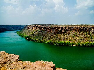
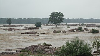
The Chambal River is a tributary of the Yamuna River in Central and Northern India, and thus forms part of the drainage system of the Ganges. The river flows north-northeast through Madhya Pradesh, running for a time through Rajasthan then forming the boundary between Rajasthan and Madhya Pradesh before turning southeast to join the Yamuna in Uttar Pradesh state.

The Kali Sindh, is a river in Madhya Pradesh and Rajasthan in northern India. It is a tributary of the Chambal River in the Ganges Basin. The main tributaries of the Kali Sindh are the Parwan, Niwaj and Ahu rivers. The Kali Sindh River drains a major portion of the Malwa region, and is the biggest river flowing in the Malwa region of Madhya Pradesh.

The Rihand River is a tributary of the Son River and flows through the Indian states of Chhattisgarh and Uttar Pradesh. Its old name was Renu or Renuka.

Jalaun district is a district of Uttar Pradesh, India. The district is named after the town of Jalaun, which was the former headquarters of a Maratha governor, but the administrative headquarters of the district is at Orai.

Guna district is one of the 52 districts of Madhya Pradesh in central India. Its administrative headquarters is Guna. The district has a population of 1,241,519. It has an area of 6390 km², and is bounded on the northeast by Shivpuri District, on the east by Ashoknagar District, on the southeast by Vidisha District, on the southwest by Rajgarh District, on the west and northwest by Jhalawar and Baran districts of Rajasthan state. The Sindh River flows northward along the eastern edge of the district, forming part of the boundary with Ashoknagar District, and the Parvati River flows northwestward through the southern portion of the district, forming part of the boundary with Baran District before flowing into Rajasthan.

GandhisagarDam is situated at a distance of 168 km from the District headquarter. The Dam is constructed on the Chambal River.

Shivpuri District is a district of Madhya Pradesh state of India. The town of Shivpuri is the district headquarters. National Highway 3 (NH-3) runs through the district.
Pahuj River is a river flowing through the city of Jhansi, Uttar Pradesh, India. It has been referred as the Pushpavati in religious texts. It is a small and dry river which passes through the Indian Grassland and Fodder Research Institute, Jhansi. It flows through the region of Bundelkhand region and a plays a major part in dividing the border of Uttar Pradesh and Madhya Pradesh. Generally it flows at a heavy water level outside its banks in the monsoon season but drastically can also go dry or with very little flow in the summers. Nowadays many electric plants in Uttar pradesh are discharging its waste in it due to which the water of the river getting contaminated day by day and also illegal mining at the banks of it is causing its state deteriorating day by day. The river is approx 195 km from its origin to mouth.

The Rana Pratap Sagar Dam is a gravity masonry dam of 53.8 metres (177 ft) height built on the Chambal River at Rawatbhata in Rajasthan in India. It is part of integrated scheme of a cascade development of the river involving four projects starting with the Gandhi Sagar Dam in the upstream reach in Madhya Pradesh and the Jawahar Sagar Dam on the downstream with a terminal structure of the Kota Barrage in Rajasthan for irrigation.
The Jawahar Sagar Dam is the third dam in the series of Chambal Valley Projects on the Chambal River, located 29 km upstream of Kota city and 26 km downstream of Rana Pratap Sagar dam. It is a concrete gravity dam, 45 meters high and 393 meters long, generating 60 MW of power with an installed capacity of 3 units of 33 MW. Its construction was completed in 1972. The dam's gross storage capacity is 67.07 million cubic meters. The total catchment area of the dam is 27,195 km2, of which only 1,496 km2 are in Rajasthan. The free catchment area below Rana Pratap Sagar dam is 2,331 km2. The dam is located after the Gandhi Sagar Dam and Rana Pratap Sagar Dam, but before the Kota Barrage.

The Matatila Dam is a dam in district Lalitpur, Uttar Pradesh, India, that was built in 1958 on the Betwa River. Situated 50 km from Jhansi and 93 km away from Deogarh, this earthen dam is 35 m high. The dam has 23 Spillway gates. The catchment area is around 20 km2 with a maximum storage capacity of 1132 million cubic metres.
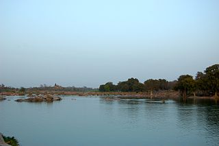
The Pachnada is an area near Sindous (सिन्डौस) at the border of Jalaun district, Etawah district and Auraiya district of Uttar Pradesh state, India. It is also near the border of Bhind district of Madhya Pradesh state, where tourists can witness the confluence of five rivers, Kunwari, Pahuj, Yamuna, Chambal and Sind. This area is a rich habitat for dolphins.
The Tamsa River is a tributary of the Ganges flowing through the Indian states of Madhya Pradesh and Uttar Pradesh.
