Gandhi Sagar Dam

Last updated

Gandhi Sagar
Gandhi Sagar Mandsaur2.JPG
Upstream view of the Gandhi Sagar Dam in 2009
Madhya Pradesh relief map.svg
Red pog.svg
Location of the dam within the state of Madhya Pradesh
India relief location map.jpg
Red pog.svg
Gandhi Sagar Dam (India)
Official nameBhadra
Location Mandsaur District Madhya Pradesh
Coordinates 24°42′24″N75°33′12″E / 24.70667°N 75.55333°E / 24.70667; 75.55333 Coordinates: 24°42′24″N75°33′12″E / 24.70667°N 75.55333°E / 24.70667; 75.55333
Opening date1960 (Stage I)
1970 (Stage II)
Construction costRs. 2.32 billion
Operator(s) Water Resources Department, Madhya Pradesh and Madhya Pradesh Power Corporation
Dam and spillways
Impounds Chambal River, a tributary of Yamuna River
Height62.17 metres (204.0 ft)
Length514 metres (1,686 ft)
Reservoir
CreatesMultipurpose
Total capacity7,322,000,000 m3 (5,936,000 acre⋅ft) (258.61 tmc ft)
Catchment area 22,584 km2 (8,720 sq mi)
Surface area723 km2 (279 sq mi)
Power Station
Hydraulic head 44 metres (144 ft)
Gandhisagar Dam [1]

GandhisagarDam is situated at a distance of 168 Kms from the District headquarter. The Dam is constructed on the Chambal River.

Contents

The Gandhi Sagar Dam is one of the four major dams built on India's Chambal River. The dam is located in the Mandsaur, districts of the state of Madhya Pradesh. It is a masonry gravity dam, standing 62.17 metres (204.0 ft) high, [1] with a gross storage capacity of 7.322 billion cubic metres from a catchment area of 22,584 km2 (8,720 sq mi). The dam's foundation stone was laid by Prime Minister of India Pandit Jawaharlal Nehru on 7 March 1954, [2] and construction of the main dam was done by leading contractor Dwarka Das Agrawal & Associates and was completed in 1960. Additional dam structures were completed downstream in the 1970s.

The dam sports a 115-MW hydroelectric power station at its toe, with five 23-MW generating units each providing a total energy generation of about 564 GWh. [3] The water released after power generation is used for the irrigation of 427,000 hectares (1,060,000 acres) by the Kota Barrage, which is located 104 kilometres (65 mi) downstream of the dam, near the city of Kota in the state of Rajasthan. [2] [4] [5]

It attracts many migratory and non-migratory birds throughout the year. The International Bird Life Agency (IBA) has qualified the reservoir under "A4iii" criteria, as the congregation of waterbirds is reported to exceed 20,000 at some points. [6]

Geography

The Gandhi Sagar Dam on the Chambal River. Gandhi Sagar Dam.JPG
The Gandhi Sagar Dam on the Chambal River.

The Chambal River (known in ancient times as the Chamranyavati River) raises in the Vindhya Range at an elevation of 853 metres (2,799 ft), 15 kilometres (9.3 mi) west-southwest of the town of Mhow, near Indore. It flows north-northeast through Madhya Pradesh, runs for a time through Rajasthan, then forms the boundary between Rajasthan and Madhya Pradesh before turning southeast to join the Yamuna River in the state of Uttar Pradesh. Its total length from its source to its confluence with the Yamuna River is 900 kilometres (560 mi). [7]

The Chambal and its tributaries drain the Malwa region of northwestern Madhya Pradesh, while its tributary, the Banas, which rises in the Aravalli Range, drains southeastern Rajasthan. At its confluence with the Yamuna, the Chambal joins four other rivers – the Yamuna, Kwari, Sind, and Pahuj – at Pachnada near Bhareh in Uttar Pradesh, at the border of the Bhind and Etawah districts. [8] [9] The river is drained by a rain-fed catchment area with an average annual rainfall of 860 millimetres (34 in), a temperature range of between 2 °C (36 °F) and 40 °C (104 °F), and a relative humidity ranging from 30% to 90%. [7]

Between 344 kilometres (214 mi) and 440 kilometres (270 mi) from the Chambal's source is an area of deep gorges; the Gandhi Sagar Dam is located in the middle reach of this gorge section. The dam is situated at a distance of 168 kilometres (104 mi) from the district administrative headquarters of Mandsaur. [2]

Construction history

The power station on the right bank of the dam and the downstream bridge across the Chambal River. Gandhi Sagar Mandsaur1.JPG
The power station on the right bank of the dam and the downstream bridge across the Chambal River.

The Chambal River Valley Development marked one of the landmark actions of the First Five-Year Plan launched by the Government of India in 1951, after India attained independence in August 1947. The Chambal River had not until then been used for any major developmental works, and was proposed to be developed under a joint initiative of the state governments of Madhya Pradesh and Rajasthan. The three-stage proposal, drawn up in 1953, called for three dams to provide hydroelectric power generation, and a downstream barrage to use stored waters released from the upstream dams for irrigation. [10] The river's drop of 625 metres (2,051 ft) between its source in Mhow and the city of Kota, which marks the exit of the river from its gorge section into the plains of Rajasthan, was seen as having great hydroelectric potential. [4] [5]

Stage I

The first stage of the development involved construction of the Gandhi Sagar Dam to a height of a 62.17 metres (204.0 ft) as a storage dam to store 7,32,20,00,000 cubic metres in Madhya Pradesh and use the stored water for hydroelectric power generation, followed by irrigation from the Kota Barrage in Rajasthan, 104 kilometres (65 mi) downstream of the dam. Power generation at Gandhi Sagar Dam was through a powerhouse at the toe of the dam, with a total installed capacity of 115 MW (divided into five units of 23 MW). [3] The Kota Barrage, an earth and masonry structure 37.34 metres (122.5 ft) in height, was built to provide irrigation through a canal system, with two main canals on the right and left banks. Construction of both projects began in 1953–54; both began functioning in 1960. The water received at the Kota Barrage is shared equally between Madhya Pradesh and Rajasthan for irrigation. [4] [5]

Stage II

The second stage of development involved the use of the water released from the Gandhi Sagar Dam through another dam structure, the Rana Pratap Sagar Dam, located 48 kilometres (30 mi) downstream of the Gandhi Sagar at Rawatbhata in the Chittorgarh District of Rajasthan. Additional storage at this dam provides an increase in irrigation benefits from the Kota Barrage, increasing its area of irrigation from 445,000 hectares (1,100,000 acres) to 567,000 hectares (1,400,000 acres). In addition, a powerhouse at the toe of the dam provides an additional hydroelectric power generation capacity of 172 MW from four turbo generators, of 43 MW capacity each. The second stage was completed in 1970. The power generated at the Rana Pratap Sagar Dam is shared equally with Madhya Pradesh, as the Gandhi Sagar Dam provides the stored waters for use at this dam. [4] [5]

Stage III

The third and final stage of development envisaged an intermediate dam between the Rana Pratap Sagar Dam and the Kota Barrage, called the Jawahar Sagar Dam. This dam is a concrete gravity dam, 45 metres (148 ft) high, located approximately 23 kilometres (14 mi) upstream of Kota Barrage to its southwest, and provides a hydroelectric power generation capacity of 99 MW, with three generator units of 33 MW capacity each. This project was commissioned in 1972. [4] [5]

Features

Gandhi Sagar Reservoir in 2009. Gandhi Sagar Mandsaur.JPG
Gandhi Sagar Reservoir in 2009.

Gandhi Sagar Dam is a masonry gravity dam with a height of 62.17 metres (204.0 ft) and a length of 514 metres (1,686 ft). The reservoir has a gross storage capacity of 7.32 billion cubic metres, with a live storage of 6.79 billion cubic metres corresponding to Full Reservoir Level (FRL) at 400 metres (1,300 ft). The spillway of the dam is designed for a discharge of 21,238 cubic metres per second. There are 10 gated spillway spans to pass the designed flood discharge. In addition, 9 river sluices have also been provided, but these have not been functional. [1] [2] [4] [5]

The hydroelectric power station is located at the toe of the dam on the right bank. The total flow through the five turbines is 311.15 m3/s. The power station has an installation of 142 MW with five turbines of 23 MW and one unit of 27 MW capacity. The power station is 65 metres (213 ft) long and 56 feet (17 m) wide. Power is supplied first to the local district and then to other regions of Madhya Pradesh and Rajasthan. [2] The Gandhi Sagar Dam and Power Station were built at a total cost of about Rs. 2.3 billion. [2]

Reservoir

The reservoir created by the dam is the third largest in India (after the Indirasagar Reservoir and Hirakud Reservoir), with a total area of 723 km2 (279 sq mi). The catchment area of the Chambal River from the Vindhyachal ranges to the south and Aravalli to the northeast, covering a drainage area of 22,584 km2 (8,720 sq mi); important tributaries that discharge into the Chambal upstream of this reservoir include the Shipra, Chhoti, Kalisindh, Ansar, and Rupniya on the eastern side, and the Tilsoi, Edar, Retum and Shivna in the west. [11] The maximum length and width of the reservoir are 68 kilometres (42 mi) and 26 kilometres (16 mi), respectively. The Gandhi Sagar Wildlife Sanctuary, which has an area of 36,700 hectares (91,000 acres), is shared by the Mandsaur and Neemuch districts, in the catchment area of the Gandhi Sagar reservoir. The sanctuary's forested area was once a hunting area of the Holkar royal family of Indore. The reservoir is under the control of the irrigation and fisheries departments of the Government of Madhya Pradesh, and is mostly used for fisheries development also. [6] [11]

The mean depth of the reservoir is 11.73 metres (38.5 ft), with a shore development index of 4.78, and a volume development index of 0.601 at the Full Reservoir Level. Scientific studies indicate that the reservoir is productive as regards fisheries, with the reservoir water indicating a moderate-to-high rate of primary productivity. Commercial Fisheries was initiated in 1959–60 in Gandhi Sagar, and has been credited as the best-managed reservoir in the state. Fish capture in the reservoir is prohibited between 16 June and 15 August. [11] The reservoir attracts many migratory and non-migratory birds throughout the year, has been qualified under "A4iii criteria" by the IBA, as the bird congregation is of more than 20,000 waterbirds. [6]

Suggested reservoir amendment

Analysis of hydroelectric power generation performed by the three power plants in the Chambal valley has been carried out by a non-governmental agency, based on statistics provided by the Central Electricity Authority under the RTI Act. The results indicate that the Gandhi Sagar reservoir attained its full storage condition only during five years of its first five decades of operation. The energy generation of all the three power plants declined by 25% in the same period of 50 years, relative to the projected 50-year figures. Keeping these aspects in view, in 2011 it was suggested[ according to whom? ] that the full reservoir level in the Gandhi Sagar Dam be reduced by suitable operational guidelines, which would enable the release of substantial submergence area for cultivation by the farmers who originally owned these lands. [10]

In 2022, a 1,440MW pumped-storage hydroelectricity project was underway, using the Gandhi Sagar reservoir as the lower reservoir. [12]

Related Research Articles

<span class="mw-page-title-main">Yamuna</span> River in India

The Yamuna, also spelt Jumna, is the second-largest tributary river of the Ganges by discharge and the longest tributary in India. Originating from the Yamunotri Glacier at a height of about 4,500 m (14,800 ft) on the southwestern slopes of Bandarpunch peaks of the Lower Himalaya in Uttarakhand, it travels a total length of 1,376 kilometres (855 mi) and has a drainage system of 366,223 square kilometres (141,399 sq mi), 40.2% of the entire Ganges Basin. It merges with the Ganges at Triveni Sangam, Allahabad, which is a site of the Kumbh Mela, a Hindu festival held every 12 years.

<span class="mw-page-title-main">Narmada River</span> River of central India in a rift valley

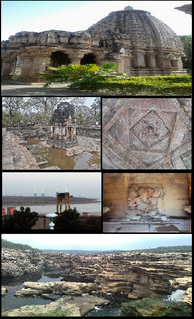
The Narmada River, also called the Reva and previously also known as Narbada or anglicised as Nerbudda, is the 5th longest river and overall longest west-flowing river in India. It is also the largest flowing river in the state of Madhya Pradesh. This river flows through the states of Madhya Pradesh and Gujarat in India. It is also known as the "Life Line of Madhya Pradesh and Gujarat" due to its huge contribution to the two states in many ways. The Narmada River rises from the Amarkantak Plateau in Anuppur district Madhya Pradesh. It forms the traditional boundary between North India and South India and flows westwards over a length of 1,312 km (815.2 mi) before draining through the Gulf of Khambhat into the Arabian Sea, 30 km (18.6 mi) west of Bharuch city of Gujarat.

<span class="mw-page-title-main">Ravi River</span> River in India and Pakistan

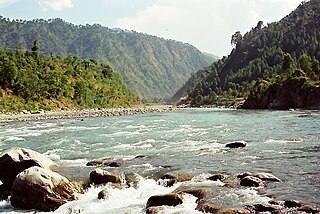
The Ravi River is a transboundary river crossing northwestern India and eastern Pakistan. It is one of five rivers associated with the Punjab region.

<span class="mw-page-title-main">Tehri Dam</span> Dam in Uttarakhand, India

With a height of 260.5 m Tehri Dam is the tallest dam in India and 12th tallest dam in the world. With a total planned installed capacity of 2400 MW, it's the biggest Hydroelectric power plant in India. It is a multi-purpose rock and earth-fill embankment dam on the Bhagirathi River in New Tehri, Tehri Garhwal district in Uttarakhand, India. It is the primary dam of the THDC India Ltd. and the Tehri hydroelectric complex. Phase 1 was completed in 2006. The Tehri Dam withholds a reservoir for irrigation, municipal water supply and the generation of 1,000 megawatts (1,300,000 hp) of hydroelectricity. The dam's 1,000 MW variable-speed pumped-storage scheme is currently under construction with expected commissioning in 2025.

<span class="mw-page-title-main">Ghaghara</span> Asian river and tributary of the Ganges

Ghaghara, also called Karnali, is a perennial trans-boundary river originating on the Tibetan Plateau near Lake Manasarovar. The Karnali cuts through the Himalayas in Nepal and joins the Sharda River at Brahmaghat in India. Together they form the Ghaghara River, a major left bank tributary of the Ganges. With a length of 507 km (315 mi) it is the longest river in Nepal. The total length of Ghaghara River up to its confluence with the Ganges at Revelganj in Bihar is 1,080 km (670 mi). It is the largest tributary of the Ganges by volume and the second longest tributary of the Ganges by length after Yamuna.

<span class="mw-page-title-main">Chambal River</span> River in India

The Chambal River is a tributary of the Yamuna River in Central and Northern India, and thus forms part of the greater Gangetic drainage system. The river flows north-northeast through Madhya Pradesh, running for a time through Rajasthan then forming the boundary between Rajasthan and Madhya Pradesh before turning southeast to join the Yamuna in Uttar Pradesh state.

<span class="mw-page-title-main">Bhakra Dam</span> Dam in Himachal Pradesh, India

Bhaakra Dam is a concrete gravity dam on the Sutlej River in Bhakra Village near Bilaspur in Bilaspur district, Himachal Pradesh in northern India. The dam forms the Gobind Sagar reservoir.

<span class="mw-page-title-main">Nagarjuna Sagar Dam</span> Dam in Telangana and Palnadu district, Andhra Pradesh

Nagarjuna Sagar Dam is a masonry dam across the Krishna River at Nagarjuna Sagar which straddles the border between Nalgonda district in Telangana and Palnadu district in Andhra Pradesh. The dam provides irrigation water to the Nalgonda, Suryapet, Krishna, NTR, Bapatla, Eluru, Palnadu, Khammam, West Godavari, Guntur, and Prakasam districts along with electricity generation.

Kota Barrage is the fourth in the series of Chambal Valley Projects, located about 0.8 km upstream of Kota City in Rajasthan. Water released after power generation at Gandhi Sagar dam, Rana Pratap Sagar dam and Jawahar Sagar Dams, is diverted by Kota Barrage for irrigation in Rajasthan and in Madhya Pradesh through canals on the left and the right sides of the river. The work on this dam started in 1954 and was completed in 1960.

The Indira Sagar Dam is the largest dam in India, in terms of volume of water stored in the reservoir. It is located on the Narmada River at the town of Narmada Nagar, Punasa in the Khandwa district of Madhya Pradesh in India. The foundation stone of the project was laid by the prime minister of India Indira Gandhi on 23 October 1984. The construction of the main dam started in 1992. The downstream projects of ISP are Omkareshwar, Maheshwar, and Sardar Sarovar Project. To build it, a town of 22,000 people and 100 villages were displaced.

<span class="mw-page-title-main">Rawatbhata</span> City in Rajasthan, India

Rawatbhata is a city, Tehsil and Nagar Palika in Chittorgarh District, Rajasthan, India. It is 131 km from Chittorgarh city, 50 km from the nearest city, Kota. The city has eight nuclear power stations, an under-construction nuclear fuel complex, and a heavy water plant. Rawatbhata also has the biggest dam of Rajasthan, Rana Pratap Sagar Dam, which is built on the Chambal River. The dam is equipped with a 172 MW hydroelectric power station.

<span class="mw-page-title-main">Srisailam Dam</span> Dam in Telangana and Andhra Pradesh, India

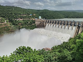
The Srisailam Dam is constructed across the Krishna River in Nagarkurnool district, Telangana and Nandyal district, Andhra Pradesh near Srisailam temple town and is the 2nd largest capacity working hydroelectric station in India.

<span class="mw-page-title-main">Rana Pratap Sagar Dam</span> Dam in Chittorgarh District, Rajasthan

The Rana Pratap Sagar Dam is a gravity masonry dam of 53.8 metres (177 ft) height built on the Chambal River at Rawatbhata in Rajasthan in India. It is part of integrated scheme of a cascade development of the river involving four projects starting with the Gandhi Sagar Dam in the upstream reach in Madhya Pradesh and the Jawahar Sagar Dam on the downstream with a terminal structure of the Kota Barrage in Rajasthan for irrigation.

The Jawahar Sagar Dam is the third dam in the series of Chambal Valley Projects on the Chambal River, located 29 km upstream of Kota city and 26 km downstream of Rana Pratap Sagar dam. It is a concrete gravity dam, 45 meters high and 393 meters long, generating 60 MW of power with an installed capacity of 3 units of 33 MW. Its construction was completed in 1972. The dam's gross storage capacity is 67.07 million cubic meters. The total catchment area of the dam is 27,195 km2, of which only 1,496 km2 are in Rajasthan. The free catchment area below Rana Pratap Sagar dam is 2,331 km2. The dam is located after the Gandhi Sagar Dam and Rana Pratap Sagar Dam, but before the Kota Barrage.

<span class="mw-page-title-main">Polavaram Project</span> Dam in Eluru district, Andhra Pradesh

The Polavaram Project is an under construction multi-purpose irrigation project on the Godavari River in the Eluru District and East Godavari District in Andhra Pradesh. The project has been accorded National project status by the Central Government of India. Its reservoir back water spreads up to the Dummugudem Anicut and approx 115 km on Sabari River side. Thus back water spreads into parts of Chhattisgarh and Odisha States. It gives major boost to tourism sector in Godavari Districts as the reservoir covers the famous Papikonda National Park, Polavaram hydro electric project (HEP) and National Waterway 4 are under construction on left side of the river. It is located 40 km to the upstream of Sir Arthur Cotton Barrage in Rajamahendravaram City and 25 km from Rajahmundry Airport.

<span class="mw-page-title-main">Idamalayar Dam</span> Dam in Ernakulam District, Kerala

Idamalayar Dam is a multipurpose concrete gravity dam located at Ennakkal between Ayyampuzha and Bhoothathankettu in Ernakulam district of Kerala on the Idamalayar, a tributary of the Periyar River in Kerala, South India. The dam however extends east as far as Malakkappara. Completed in 1985, with a length of 373 metres (1,224 ft) and a height of 102.8 metres (337 ft), the dam created a multipurpose reservoir covering 28.3 km2 (10.9 sq mi) in the scenic hills of the Anamalais.

Narmada Valley Development Authority (NVDA) concerns Narmada River, the river of Madhya Pradesh. With 87% of its catchment area lying in Madhya Pradesh, it becomes all the more important for the state to exploit this enormous water resource. It was with this motto in mind that the Narmada Valley Development Authority (NVDA) was formed by the government of MP on 9 August 1985. NVDA oversees all major development projects in the Narmada Basin. The body also ensures that proper rehabilitation is provided to the displaced, and the negative impacts on environment are minimized by taking appropriate measures.

<span class="mw-page-title-main">Pandoh Dam</span> Dam in Mandi district

The Pandoh Dam is an embankment dam on the Beas River in Mandi district of Himachal Pradesh, India. Under the Beas Project, the dam was completed in 1977 and its primary purpose is hydroelectric power generation. Part of a run-of-the-river power scheme, it diverts the waters of the Beas to the southwest through a 38 km (24 mi) long system of tunnels and channels. The water is used for power generation at the Dehar Power House before being discharged into the Sutlej River, connecting both rivers. The power house has an installed capacity of 990 MW. The system diverts 256 cumecs of Beas waters to the Satluj River. The project was completed in 1977.

The Pong Dam, also known as the Beas Dam, is an earth-fill embankment dam on the Beas River in the state of Himachal Pradesh, India, just upstream of Talwara. The purpose of the dam is water storage for irrigation and hydroelectric power generation. As the second phase of the Beas Project, construction on the dam began in 1961 and was completed in 1974. At the time of its completion, the Pong Dam was the tallest of its type in India. The lake created by the dam, Maharana Pratap Sagar, became a renowned bird sanctuary.

Lakhwar-Vyasi Dam project on Yamuna River, includes under-construction Lakhwar Dam and Power Station, Vyasi Dam, Hathiari Power Station and Katapathar Barrage, near the Lakhwar town in Kalsi block of Dehradun district of Uttarakhand in India, for the purpose of irrigation of 40,000 hectare land and total 927 MW hydroelectric power generation. "Lakhwar Dam" is a gravity dam near the Lohari village with 300MW power generation capacity. "Vyasi Dam" will be built 5 km downstream along with 120 MW "Hathiari Power Station" further 0.5 km downstream. "Katapathar Barrage", with the maximum ponding water level at 514.5m elevation, will be built further 2.75 km downstream of the Hathiari Power Station to supply the water to stakeholder states. Project will hold 580 million cubic metres water during monsoon and release into Yamuna during dry months.

References

  1. 1 2 3 "National Register of Large Dams" (PDF). Madhya Pradesh Sr No. 124. Central Water Commission. Retrieved 10 May 2011.
  2. 1 2 3 4 5 6 "Gandhisagar Dam". National Informatics Center Mandsur. Archived from the original on 3 February 2012. Retrieved 11 May 2011.
  3. 1 2 "Consultancy for formulating operational cost norms including O&M and escalation for Hydro Power for the Central Electricity Regulatory Commission" (PDF). Gandhi Sagar: Annexure 3, sr.no. 36. Central Electricity Regulatory Commission. Archived from the original (PDF) on 9 March 2012. Retrieved 11 May 2011.
  4. 1 2 3 4 5 6 "Command Area Development Chambal, Kota". Kota Division National Informatics Centre. Archived from the original on 23 March 2012. Retrieved 10 May 2011.
  5. 1 2 3 4 5 6 "Chambal Valley Project". Government of Rajasthan. Retrieved 10 May 2011.
  6. 1 2 3 "Important Bird Areas in India – Madhya Pradesh" (PDF). Gandhisagar Reservoir. IBA. Retrieved 11 May 2011.[ permanent dead link ]
  7. 1 2 Jain, Sharad K.; Pushpendra K. Agarwal; Vijay P. Singh (2007). Hydrology and water resources of India- Volume 57 of Water science and technology library – Tributaries of Yamuna river. Springer. pp. 350–351. ISBN   978-1-4020-5179-1.
  8. "Chambal River (in Chambal River (river, India))". Encyclopædia Britannica. Retrieved 10 May 2011.
  9. "Chambal Valley". Encyclopædia Britannica. Retrieved 10 May 2011.
  10. 1 2 "The strong case for reducing the FRL of the Chambal Dam" (PDF). AgropediaLabs.iitk.ac.in. Retrieved 11 May 2011.[ permanent dead link ]
  11. 1 2 3 "Gandhisagar Reservoir". FAO.org. Retrieved 11 May 2011.
  12. Colthorpe, Andy (29 September 2022). "Greenko appoints electromechanical contractor for 1,440MW India pumped hydro project". Energy Storage News.