
The Krishna River is a river in the Deccan plateau and is the third-longest river in India, after the Ganges and Godavari. It is also the fourth-largest in terms of water inflows and river basin area in India, after the Ganges, Indus and Godavari. The river, also called Krishnaveni, it is 1,400 kilometres (870 mi) long and its length in Maharashtra is 282 kilometres. It is a major source of irrigation in the Indian states of Maharashtra, Karnataka, Telangana and Andhra Pradesh.

The Godavari is India's second longest river after the Ganga river and drains into the third largest basin in India, covering about 10% of India's total geographical area. Its source is in Trimbakeshwar, Nashik, Maharashtra. It flows east for 1,465 kilometres (910 mi), draining the states of Maharashtra (48.6%), Telangana (18.8%), Andhra Pradesh (4.5%), Chhattisgarh (10.9%) and Odisha (5.7%). The river ultimately empties into the Bay of Bengal through an extensive network of tributaries. Measuring up to 312,812 km2 (120,777 sq mi), it forms one of the largest river basins in the Indian subcontinent, with only the Ganga and Indus rivers having a larger drainage basin. In terms of length, catchment area and discharge, the Godavari is the largest in peninsular India, and had been dubbed as the Dakshina Ganga.
The Chota Nagpur Plateau is a plateau in eastern India, which covers much of Jharkhand state as well as adjacent parts of Chhattisgarh, Odisha, West Bengal and Bihar. The Indo-Gangetic plain lies to the north and east of the plateau, and the basin of the Mahanadi river lies to the south. The total area of the Chota Nagpur Plateau is approximately 65,000 square kilometres (25,000 sq mi).
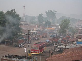
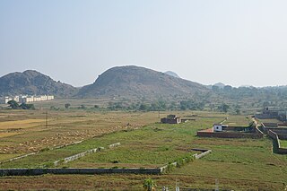
Latehar is a town which is a headquarter of Latehar district of Jharkhand state, it is known for its natural environment, forest, forest products and mineral deposits. Latehar remained a part of Palamau District as a sub division since 1924. It was elevated from sub divisional status to a district on 4 April 2001, vide Jharkhand Government Notification No 946 dated 04.04.2001. Latehar is located on the north–west corner of Jharkhand in the Palamau Commissionary. It is surrounded by Ranchi, Lohardaga, Gumla, Palamu and Chatra district apart from Chhattisgarh state and district headquarters is situated at 84.51198 East Longitude and 23.741988 North Latitude.

Palamu district is one of the twenty-four districts of Jharkhand, India. It was formed in 1892. The administrative headquarters of the district is Medininagar, situated on the Koel River.

Latehar district is one of the 24 districts of Jharkhand state in eastern India, and Latehar town is the administrative headquarters of this district. This district is part of Palamu division.
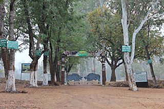
Betla National Park is a national park located on the Chota Nagpur Plateau in the Latehar and Palamu district of Jharkhand, India. The park hosts a wide variety of wildlife.

The Manas River, known in Bhutan as the Drangme Chhu, is a transboundary river in the Himalayan foothills between southern Bhutan, India, and China. It is the largest of Bhutan's four major river systems, with the other three being the Amo Chu or Torsa River, the Wong Chu or Raidak, and the Puna Tshang Chu or Sankosh. It is met by three other major streams before it again debouches into India in western Assam. The river flows for a total length of 400 kilometres (250 mi), including through Tibet for 24 km (15 mi), Bhutan for 272 kilometres (169 mi), and Assam for 104 kilometres (65 mi) before it joins the mighty Brahmaputra River at Jogighopa. A major tributary of the Manas, the Aie River, joins it in Assam at Bangpari.
The Burha River flows through the Latehar district of Palamu division in the Indian state of Jharkhand.
North Koel River flows through the Indian state of Jharkhand.
The Auranga River flows through the Latehar and Palamu districts in the Indian state of Jharkhand.
The Mohana River flows through the Hazaribagh, Chatra and Gaya districts in the Indian states of Jharkhand and Bihar.
The Lilājan River is a river that flows through the Chatra and Gaya districts in the Indian states of Jharkhand and Bihar. It is also referred to as the Nilanjan, Niranjana or Falgu River.

The Punpun River is a tributary of the Ganges. It originates in Palamu district of Jharkhand and flows through Chatra, Aurangabad, Gaya and Patna districts of the Indian states of Jharkhand and Bihar. Punpun is a place named after the Punpun river in Patna which is situated on the bank of Punpun river. On the bank of Punpun people celebrate Chhath Puja.
Kunda is a community development block that forms an administrative division in the Chatra subdivision of the Chatra district, Jharkhand state, India.
Lawalong is a community development block that forms an administrative division in the Simaria subdivision of the Chatra district, Jharkhand state, India.
Simaria subdivision is an administrative subdivision of the Chatra district in the North Chotanagpur division in the state of Jharkhand, India.
The Tritiya Prastuti Committee (TPC) is a splinter group of the Maoist Communist Centre of India. TPC has declared Communist Party of India (Maoist) as its main enemy not police machinery. The area of influence of TPC are in Chatra, Palamu and Latehar district of Jharkhand. TPC is rival of other Maoist outfits.
Lawalong Wildlife Sactuary is located in the Lawalong CD block in the Chatra subdivision of the Chatra district in the state of Jharkhand, India.
Lawalong is a village and gram panchayat in the Lawalong CD block in the Simaria subdivision of the Chatra district in the Indian state of Jharkhand.

