Cities, towns and locations in Ranchi District in South Chotanagpur Division M: municipality, CT: census town, R: rural/ urban centre, N: neighbourhood, T: tourist centre, D: dam, H: historical/ religious centre Owing to space constraints in the small map, the actual locations in a larger map may vary slightly
Note: The map alongside presents some of the notable locations in the district. All places marked in the map are linked in the larger full-screen map.
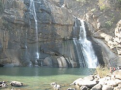
The falls
Hundru Falls
Hundru Falls are located on the course of the Subarnarekha River where it falls from a height of 98 metres (322ft), creating one of the highest waterfalls in the state. The spectacular scene of the waterfalls has been described as "a sight to behold".[citation needed] The different formations of rock due to the erosion by the constantly falling of water have added to the beauty of the place.[5][6][7]
Hundru Falls, located at one of the edges of the Ranchi plateau, is one of the several scarp falls in the region.[8] During the rainy season it takes a formidable form, but in the dry season it turns into an exciting picnic spot.[9] At the base of the falls is a pool that serves as a bathing place.[5][10]
Hundru Falls is an example of a knickpoint, caused by rejuvenation. A knickpoint, also called a nick point or simply nick, represents a break in slopes in the longitudinal profile of a river. The break in channel gradient allows water to fall vertically, giving rise to a waterfall.[11]
Transport
To reach Hundru Falls, one has to travel about 21 kilometres (13mi) from the main road, Purulia Road.[7][12]
There is also a shortcut and simple four-lane road from Ranchi via Ormanjhi via Sikidiri to Hundru. From this road the distance is about 39 kilometres (24mi) which is about 6 kilometres (3.7mi) short from the normal road.
There is also a Suvarna Rekha Hydral Project located down the falls, which is a good place for tourists.[7]
This page is based on this Wikipedia article Text is available under the CC BY-SA 4.0 license; additional terms may apply. Images, videos and audio are available under their respective licenses.