This article needs additional citations for verification .(December 2014) |
| Getalsud Dam (Rukka Dam) | |
|---|---|
 Getalsud Dam, Jharkhand | |
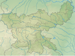 Getalsud Dam (Rukka Dam) Location in Jharkhand | |
| Country | India |
| Location | Ormanjhi, Ranchi, Jharkhand |
| Coordinates | 23°27′24″N85°33′19″E / 23.45667°N 85.55528°E |
| Status | Functional |
| Opening date | 1971 |
| Owner | JSEB |
| Dam and spillways | |
| Type of dam | Concrete gravity dam |
| Impounds | Subarnarekha River |
| Height | 116 ft (35 m) |
| Reservoir | |
| Catchment area | 717 km2 (277 sq mi) |
| Normal elevation | 1,954 ft (596 m) |
| Power Station | |
| Operator | JSEB |
| Turbines | 2 x 65 MW Francis-type |
| Installed capacity | 130 MW [1] |
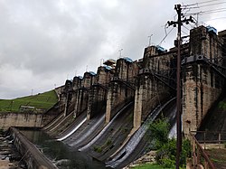
Getalsud Dam is an artificial reservoir situated in Ormanjhi, Ranchi, Jharkhand. It was constructed across the Subarnarekha River and was opened in 1971. It is a popular picnic spot for the residents of Ranchi and Ramgarh District. The dam provides a small-scale fishing opportunity to the local people of Rukka. The main purpose of the dam is to fulfill the drinking water requirements of the residents of Ranchi. Apart from that, it is used for industrial purposes and generating electricity.


