Subarnarekha River

Last updated
Subarnarekha River
Swarnarekha River
Subarnarekha.JPG
Subarnarekha in December 2005 at Gopiballavpur
India Odisha relief map.svg
Red pog.svg
Location of the mouth in India
India relief location map.jpg
Red pog.svg
Subarnarekha River (India)
Location
Country India
State Jharkhand, Odisha, West Bengal
Cities Ranchi, Chandil, Jamshedpur, Ghatshila, Gopiballavpur, Jaleswar
Physical characteristics
Source 
  locationPiska/ Nagri(Rani Chuan)near Ranchi, Chota Nagpur Plateau
  coordinates 23°18′N85°11′E / 23.300°N 85.183°E / 23.300; 85.183
  elevation610 m (2,000 ft)
Mouth Bay of Bengal
  location
Kirtania port, Odisha, India
  coordinates
21°33′18″N87°23′31″E / 21.55500°N 87.39194°E / 21.55500; 87.39194 Coordinates: 21°33′18″N87°23′31″E / 21.55500°N 87.39194°E / 21.55500; 87.39194
Length395 km (245 mi) [1]
Basin size18,951 km2 (7,317 sq mi) [1]
Discharge 
  average392 m3/s (13,800 cu ft/s)
Discharge 
  location Kokpara [2]
  average310 m3/s (11,000 cu ft/s)
  minimum1 m3/s (35 cu ft/s)
  maximum2,205 m3/s (77,900 cu ft/s)
Basin features
Tributaries 
  leftDulang River
  rightKanchi River, Kharkai, Karkari River, Raru River, Garru River

The Subarnarekha River (also called the Swarnarekha River) [3] flows through the Indian states of Jharkhand, West Bengal and Odisha.

Contents

Etymology

As per tradition, gold was mined near the origin of the river at a village named Piska near Ranchi. This is why it was named Subarnarekha, meaning "streak of gold". [4] [5] Legend has it that traces of gold were found in the river bed. Even now, people look for traces of gold particles in its sandy beds. The name is a combination of two words meaning gold and line/ streak in Indian languages. [6] [7]

Course

Subarnarekha river in Ghatshila, Jharkhand Subarnarekha river in Ghatshila, Jharkhand.jpg
Subarnarekha river in Ghatshila, Jharkhand

After originating near piska/nagri, near Ranchi, the capital of Jharkhand, [8] [9] the Subarnarekha traverses a long distance through Ranchi [10] Seraikela Kharsawan [11] and East Singhbhum [12] districts in the state. Thereafter, it flows for shorter distances through Paschim Medinipur district in West Bengal for 83 kilometres (52 mi) and Balasore district of Odisha. There, it flows for 79 kilometres (49 mi) and joins the Bay of Bengal near Talsari. The total length of the river is 395 kilometres (245 mi). [1]

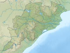
The basin of the Subarnarekha is smaller than most multi-state river basins in India. The rain-fed river covers a drainage area of 18,951 square kilometres (7,317 sq mi) [1]

Tributaries

Fishing at Subarnarekha river near Domohani (confluence of Subarnarekha and Kharkhai) Fishing at Subarnarekha river near Domohani (River meets).jpg
Fishing at Subarnarekha river near Domohani (confluence of Subarnarekha and Kharkhai)

The prominent tributaries of the Subarnarekha are Kharkai, Roro, Kanchi, Harmu Nadi, Damra, Karru, Chinguru, Karakari, Gurma, Garra, Singaduba, Kodia, Dulunga and Khaijori. [9] The Kharkai meets the Subarnarekha at Sonari (Domuhani), a neighborhood of Jamshedpur. [13]

Hundru Falls

Hundru Falls Hundru falls.JPG
Hundru Falls

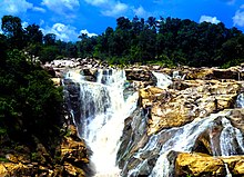
Hundru Falls is created on the course of the Subarnarekha, where it falls from a height of 98 metres (322 ft). The spectacular sight of water falling from such a great height is a sight to behold. The different rock formations due to erosion by the constantly falling water have added to the beauty of the place. [14] [15] [16]

Pollution

The Subarnarekha passes through areas with extensive mining of copper and uranium ores. As a result of the unplanned mining activities, the river is polluted. The Subarnarekha has been the lifeline of tribal communities inhabiting the Chhotanagpur region and water pollution affects their livelihood. It is getting more pollutants from the aluminium factory of Muri. [5]

Flood

Several areas in the lower reaches of the Subarnarekha, particularly the coastal areas of Odisha and West Bengal, are within the flood hazard zone. The Subarnarekha in Odisha had crossed its previous Highest Flood Level (HFL) of 12.2 metres (40 ft) in 2007, surpassing the earlier record of 1997. In 2009, the Subarnarekha witnessed flash floods following heavy rainfall in the upper catchment areas of the river. [17] [18] [19] During the flood, large areas of Jaleswar, Bhograi and Baliapal blocks and a small pocket of Basta block in Balasore district of Odisha were affected. [20] Certain areas of Medinipur in West Bengal are also affected by floods. [6]

Projects

Sunset across Getalsud reservoir Getalsud Dam.jpg
Sunset across Getalsud reservoir

Getalsud

Getalsud reservoir is located across the Subernarekha, 40 kilometres (25 mi) east of Ranchi and about 50 kilometres (31 mi) from its point of origin. Completed in 1971, this multi-purpose reservoir was envisaged mainly to meet municipal water demands of Ranchi city and the adjoining industrial area. The height of the dam is 35.5 metres (116 ft). There are two power houses in Sikidiri with one unit of 65 MW each. Sikidiri Hydal Power Plants are the only hydal projects in Jharkhand. [9]

Subarnarekha multipurpose project

The Subarnarekha multipurpose project envisaged the construction of two dams, one at Chandil across the Subarnarekha and the other across the Kharkai at Icha near Chaibasa, two barrages at Galudih across the Subarnarekha and the other across the Kharkai at Ganjia near Adityapur and a network of canals from these. Three small storage reservoirs and a network of canals from these reservoirs are in Orissa. Started in 1982–83, the multipurpose project was planned for irrigation, hydropower generation and water supply. While the Chandil dam and Galudih barrage are almost complete, the other components are still incomplete. [9] [21] Subernarekha Barrage project (West Bengal) envisages construction of a barrage across the Subarnarekha downstream of Chandil dam and Galudih barrage near Bhosraghat to irrigate 114,198 hectares (282,190 acres) annually in the Medinipur district of West Bengal through a left bank canal and its distribution system covering a culturable command area of 96,860 hectares (239,300 acres). The project was taken up for construction in the year 1995–96. [22]

Completed Chandil Dam Chandil Dam.JPG
Completed Chandil Dam

The Chandil Dam and reservoir required 17,028 hectares (42,080 acres) of land. Icha Dam submerged 8,585 hectares (21,210 acres) of land in Jharkhand and 4,415 hectares (10,910 acres) of land in Orissa.[ citation needed ] The Ganjia Barrage required 266 hectares (660 acres) of land. Galudiha Barrage required 180 hectares (440 acres) of land, of which 150 hectares (370 acres) was private land and 30 hectares was Revenue Land. The canal network required additional land. The project experienced protests from its inception in 1975 and, in 1978, some 10,000 of them demonstrated against the dam at the construction site. [23] [24] To address the protests, the government increased the compensation package for 12,000 families and 2,200 people got jobs in different government departments. [25] [26]

The construction of Chandil dam, Icha dam and Galudih barrage are complete. This dam is one of the most visited places of Jharkhand. The museum located close to the Chandil dam has scripts written on rocks, which are 2,000 years old.

Subarnarekha port

Dassam fall on Kanchi River before it merges with Subarnarekha Dassam fall, ranchi.jpg
Dassam fall on Kanchi River before it merges with Subarnarekha

The Government of Odisha has signed a memorandum of understanding with Chennai-based Creative Port Development Pvt. Ltd. for the development of a deep-water, all-weather project at Kirtania at the mouth of the Subarnarekha. The Kirtania Port project was being taken up on a 50-year build, own, operate, share and transfer (boost) basis. The development would include a dedicated rail cum road connection from the port to the NH 5 and rail network at Jaleswar. [27] [28] More recently the project is being referred to as Subarnarekha port. The foundation stone was laid in 2019. [29]

Film

Ritwik Ghatak directed a Bengali film Subarnarekha in 1965. Ghatak's films are deeply haunted by the spectre of the partition of Bengal in 1947. In the film Subarnarekha, Ghatak "has rendered the very idea of home as a sentimental place on an elusive other side that, like the distant, opposing banks of the Subarnarekha River, symbolically represents an idealized, and intranscendible, elsewhere." [30]

Related Research Articles

<span class="mw-page-title-main">Jharkhand</span> State in eastern India

Jharkhand is a state in eastern India. The state shares its border with the states of West Bengal to the east, Chhattisgarh to the west, Uttar Pradesh to the northwest, Bihar to the north and Odisha to the south. It has an area of 79,716 km2 (30,779 sq mi). It is the 15th largest state by area, and the 14th largest by population. Hindi is the official language of the state. The city of Ranchi is its capital and Dumka its sub-capital. The state is known for its waterfalls, hills and holy places; Baidyanath Dham, Parasnath, Dewri and Rajrappa are major religious sites.

<span class="mw-page-title-main">Chota Nagpur Plateau</span> Plateau of India

The Chota Nagpur Plateau is a plateau in eastern India, which covers much of Jharkhand state as well as adjacent parts of Chhattisgarh, Odisha, West Bengal and Bihar. The Indo-Gangetic plain lies to the north and east of the plateau, and the basin of the Mahanadi river lies to the south. The total area of the Chota Nagpur Plateau is approximately 65,000 square kilometres (25,000 sq mi).

<span class="mw-page-title-main">Seraikela Kharsawan district</span> District of Jharkhand in India

Seraikela-Kharsawan district or Saraikella and Kharaswan district is one of the twenty-four districts of Jharkhand state in eastern India. Seraikela town is the district headquarters of Saraikela Kharsawan district. The district is well known for Seraikela Chhau, one of the three distinctive styles of the chhau dance. This district was carved out from West Singhbhum district in 2001. The district was formed from the Odia princely states of Seraikela and Kharaswan, after the independence of India.

<span class="mw-page-title-main">Damodar River</span> River in Jharkhand and West Bengal, India

Damodar River is a river flowing across the Indian states of Jharkhand and West Bengal. The valley is rich in mineral resources and is home to large-scale mining and industrial activity. It was also known as the Sorrow of Bengal because of its ravaging floods in the plains of West Bengal. The construction of several dams on the Damodar and its tributaries has helped control some of the flooding.

<span class="mw-page-title-main">Baitarani River</span> River in India

The Baitarani is one of six major rivers of Odisha, India. Venerated in popular epics and legends, the Baitarani River is a source of water for agricultural irrigation. The coastal plain of Odisha has the name of "Hexadeltaic region" or the "Gift of Six Rivers". These deltas divide the coastal plain into three regions from north to south. The Baitarani, the Mahanadi and the Brahmani rivers form the Middle Coastal Plain, with evidence of past "back bays" and present lakes.

Chandil is a census town in the Chandil CD block in the Chandil subdivision of Seraikela Kharsawan district in the state of Jharkhand, India.

<span class="mw-page-title-main">Damodar Valley Corporation</span> Multipurpose river valley project in India

Damodar Valley Corporation (DVC) is a government-owned power generator which operates in the Damodar River area of West Bengal and Jharkhand states of India to handle the Damodar Valley Project, the first multipurpose river valley project of independent India. Indian Astrophysicist Meghnad Saha, the former chief architect of river planning in India, prepared the original plan for the Damodar Valley Project. The statutory corporation operates both thermal power stations and hydel power stations under the ownership of Ministry of Power, Government of India. DVC is headquartered in the Kolkata city of West Bengal, India.

Muri is a census town in the Silli CD block in the Ranchi Sadar subdivision of Ranchi district in the Indian state of Jharkhand. It is an important railway junction and is famous for Hindalco's alumina refinery.

<span class="mw-page-title-main">Geography of Odisha</span>

Odisha is one of the 28 states in the Republic of India. Odisha is located in the eastern part of the Indian peninsula and the Bay of Bengal lies to its East while Chhattisgarh shares its border in the west and north-west. The state also shares geographic boundaries with West Bengal in the north-east, Jharkhand in the north and Andhra Pradesh in the south. The state is spread over an area of 1,55,707 km2 and extends for 700 km from north to south and 500 kilometres from east to west. Its coastline is 450 km long. The state is divided into 30 districts which are further subdivided into 314 blocks.

<span class="mw-page-title-main">South Koel River</span> River in Odisha, India

South Koel River is a 285 kilometres (177 mi) long river which runs across Jharkhand and Odisha states in India. It originates on the Lawapani Waterfalls, near Lohardaga, Chota Nagpur Plateau a Lawapani Waterfalls, near Lohardaga, Chota Nagpur Plateau 82.5 kilometres (51 mi) from Ranchi, and conjoins the Belsiangar and Singbhum Rivers. The Koel is fed by three streams in Jharkhand, namely the North Karo, South Karo and Koina. The South Koel enters Odisha and joins with Sankh River at Vedavyas near Rourkela from where it is named as Brahmani.

The Kharkai River is a river in eastern India. It is one of the major tributaries of the Subarnarekha River. It flows through Adityapur region of Jamshedpur

<span class="mw-page-title-main">Hundru Falls</span> Waterfall on the Subarnarekha River in Jharkhand, India

The Hundru Falls is a waterfall located in Ranchi district in the Indian state of Jharkhand. It is the 34th highest waterfall in India. It is one of the most famous tourist places in the region.

Subarnarekha port formerly known as Kirtania port is a deep-water, all-weather port proposed to be constructed at the mouth of Subarnarekha River in Balasore district in the Indian state of Odisha. The foundation stone for the port was laid in 2019.

Tilaiya Dam was the first of the four multi-purpose dams included in the first phase of the Damodar Valley Corporation. It was constructed across the Barakar River, at Tilaiya in Koderma district in the Indian state of Jharkhand and opened in 1953.

Tourism in Jharkhand refers to tourism in the Indian state of Jharkhand. Jharkhand is known for its waterfalls, hills and holy places.

<span class="mw-page-title-main">Jhargram district</span> District in West Bengal, India

Jhargram is a district in the state of West Bengal, India.The district lies between the Kangsabati River in the north and the Subarnarekha in the south. Jhargram has one of the lowest population densities among the districts of West Bengal, with almost all its population living in rural areas. It is a popular tourist destination known for its sal forests, elephants, ancient temples and royal palaces. The district was formed on 4 April 2017, after bifurcation from the Paschim Medinipur district as the 22nd district of West Bengal. The district has its headquarters at Jhargram.

<span class="mw-page-title-main">2017 West Bengal floods</span>

Following heavy rain in July and August 2017, the Indian state of West Bengal was affected by severe flooding. The floods were reported to have caused 50 deaths since 1 August and 8 deaths in the neighbouring state of Jharkhand.

Tamar is a village in the Tamar CD block in the Bundu subdivision of the Ranchi district in the Indian state of Jharkhand.

<span class="mw-page-title-main">Chandil Dam</span> Dam in Seraikela Kharsawan district, Jharkhand

Chandil Dam was built across the Subarnarekha, in Bihar, as a part of the Subarnarekha Multipurpose Project.

Galudih is a village in the Ghatshila CD block in the Ghatshila subdivision of the East Singhbhum district, Jharkhand, India.

References

  1. 1 2 3 4 "Subarnarekha". Water Resources Information System of India. Retrieved 2014-04-03.
  2. "Subarnarekha Basin Station: Kokpara". UNH/GRDC. Retrieved 2013-10-01.
  3. "Report on National Aquifer Mapping and Management Plan Parts of Ranchi, Khunti and Lohardagga Districts, Jharkhand" (PDF). Ranchi: Central Ground Water Board. p. 8.
  4. "Swarna Rekha in Jharkhand". mapsofindia. Archived from the original on 2009-11-03. Retrieved 2010-04-24.
  5. 1 2 "Subarnarekha River". rainwaterharvesting. Retrieved 2010-04-24.
  6. 1 2 "Rivers in Medinipur District". midnapore.in. Retrieved 2010-04-24.
  7. "Next weekend you can be at ... Galudih". The Telegraph, 1 May 2005. Archived from the original on May 1, 2005. Retrieved 2010-04-24.
  8. "Hydrology and Water Resources Information System - Subernarekha Basin" . Retrieved 2010-04-26.[ permanent dead link ]
  9. 1 2 3 4 "River System & Basin Planning" (PDF). Retrieved 2010-04-24.
  10. "Ranchi district". District administration. Retrieved 2010-04-26.
  11. "Seraikela Kharswan". District administration. Retrieved 2010-04-26.
  12. "East Singhbhum". District administration. Retrieved 2010-04-26.
  13. "Kharkai River". india9. Retrieved 2010-04-25.
  14. "Hundru Falls Ranchi". Maps of India. Retrieved 2010-04-20.
  15. "The other side of this industrial city". The Hindu Business Line, 28 July 2003. Retrieved 2010-04-20.
  16. "Hundru Falla". District administration. Archived from the original on 2010-01-24. Retrieved 2010-04-20.
  17. "Generation of a Coastal Flood Hazard Zonation Map of Midnapur-Balasore Coast in Eastern India using Integrated Remote Sensing and GIS Techniques" (PDF). Department of Geology and Geophysics Indian Institute of Technology, Kharagpur-721302. Retrieved 2010-04-25.
  18. "Flood". NRSC Decision Support Centre. Archived from the original on 2010-02-24. Retrieved 2010-04-25.
  19. "Subarnarekha, Jalaka flowing above red mark". India Environment Portal. Retrieved 2010-04-25.
  20. "Subarnarekha river". Balasore district administration. Archived from the original on 2009-08-22. Retrieved 2010-04-25.
  21. Chadha, Ashish (1993). "Subarnarekha Project – Singhbhum's Sorrow". Economic and Political Weekly. 28 (41): 2194–2196. JSTOR   4400253.
  22. "Subarnarekha Project". Press Information Bureau. Retrieved 2010-04-24.
  23. "Dams, Indigenous Peoples and Ethnic Minorities" (PDF). World Commission on Dams. Archived from the original (PDF) on 2011-06-07. Retrieved 2010-04-24.
  24. "DAMS, DISPLACEMENT, POLICY AND LAW IN INDIA" (PDF). Retrieved 2010-04-24.
  25. "The Telegraph - Ranchi". www.telegraphindia.com. Archived from the original on September 24, 2015. Retrieved 6 April 2018.
  26. "Archived copy" (PDF). Archived from the original (PDF) on 2016-03-04. Retrieved 2014-06-14.{{cite web}}: CS1 maint: archived copy as title (link)
  27. "Govt sign MOU to set up port in river Subarnarekha at Kirtania". Archived from the original on 2011-07-25. Retrieved 2010-04-24.
  28. "DEVELOPMENT OF PORT AT SUBARNAREKHA". Archived from the original on 2010-03-10. Retrieved 2010-04-24.
  29. "Foundation stone laid for Subarnarekha port in Odisha". The Hindu. 14 February 2019. Retrieved 12 February 2020.
  30. "Subarnarekha – the Golden Thread, 1965, Ritwik Ghatak". Shooting Down Pictures. Retrieved 2010-04-24.