Nalanda district

Last updated

Nalanda district
Nalanda Univercity.JPG
Son Bhandar Caves, Rajgir.jpg
Bihar district location map Nalanda.svg
Location of Nalanda district in Bihar
CountryFlag of India.svg  India
State Bihar
Division Patna
Established9 November 1972
Headquarters Bihar Sharif
Government
   Lok Sabha constituencies Nalanda
Area
  Total2,367 km2 (914 sq mi)
  Urban
112.91 km2 (43.59 sq mi)
Population
 (2011)
  Total2,877,653
  Density1,200/km2 (3,100/sq mi)
Demographics
   Literacy 66.41 (M=77.11; F=54.76)
  Sex ratio921 (2011)
Time zone UTC+05:30 (IST)
PIN Code
803111 [1]
Major highways NH 20, NH 33, NH 120, NH 431
Website Nalanda District
Administrative map of Nalanda district ADMINISTRATIVE MAP NALANDA.jpg
Administrative map of Nalanda district

Nalanda district is one of the thirty-eight districts of the state of Bihar in India. Bihar Sharif is the administrative headquarters of this district. The districts is home to the ancient Nalanda Mahavihara a UNESCO World Heritage Site. Nalanda is located in the Magadh region of southern Bihar. [2]

Contents

History

Nalanda became a fully-fledged district when it was split from Patna on 9 November 1972. [3] [4]

Geography

Nalanda district occupies an area of 2,355 square kilometres (909 sq mi). [5] The Phalgu, Mohane, Jirayan, and Kumbhari rivers flow through it. The district is a part of Patna Division. Majority of the land in the district is fertile land of Indo Gangetic plane. In the extreme South, there lies the hills of Rajgir. There is also one small hillock in the district headquarters of Bihar Sharif.

Flora and fauna

In 1978 Nalanda district became home to the Pant Wildlife Sanctuary, Rajgir which has an area of 35.84 km2 (13.8 sq mi). [6]

Demographics

Historical population
YearPop.±% p.a.
1901595,009    
1911589,310−0.10%
1921577,663−0.20%
1931676,424+1.59%
1941785,619+1.51%
1951926,189+1.66%
19611,086,972+1.61%
19711,304,832+1.84%
19811,639,922+2.31%
19911,996,257+1.99%
20012,370,528+1.73%
20112,877,653+1.96%
source: [7]
Religions in Nalanda District (2011) [8]
ReligionPercent
Hinduism
92.78%
Islam
6.88%
Others
0.34%

According to the 2011 census Nalanda district has a population of 2,877,653, [9] roughly equal to the nation of Mongolia [10] or the US state of Kansas. [11] This gives it a ranking of 134th in India (out of a total of 640), [9] and 18th in state. The district has a population density of 1,220 inhabitants per square kilometre (3,200/sq mi). [9] Its population growth rate over the decade 2001-2011 was 21.18%. [9] Nalanda has a sex ratio of 921 females for every 1000 males, [9] and a literacy rate of 66.41%. 15.91% of the population lives in urban areas. Scheduled Castes and Scheduled Tribes make up 21.12% and 0.05% of the population respectively. [9]

Languages of Nalanda district (2011) [12]

   Magahi (56.27%)
   Hindi (37.28%)
   Urdu (5.69%)
  Others (0.76%)

At the time of the 2011 Census of India, 56.27% of the population in the district spoke Magahi, 37.28% Hindi and 5.69% Urdu as their first language. [12]

Politics

Since Kurmis are dominant in Nalanda, it is also known by the name Kurmistan in political circle. [13] Nalanda district is the birthplace of Chief Minister of Bihar, Nitish Kumar. The Nalanda district comprises Nalanda Lok Sabha constituency, which can further be fragmented into seven Legislative Assembly constituencies. In 2015 Bihar Assembly elections, Janata Dal (United) (JDU), the political party led by Kumar was able to win five out of seven Legislative Assembly constituencies of the district. It has been stated that preponderance of Kushwahas apart from Kurmis and sizeable population of Extremely Backward Castes, who are considered as the supporters of Kumar, has been the prime factor behind success of JDU in polls conducted in this district. [14]

DistrictNo.ConstituencyNamePartyAllianceRemarks
Nalanda 171 Asthawan Jitendra Kumar JD(U) NDA
172 Biharsharif Sunil Kumar BJP NDA
173 Rajgir Kaushal Kishore JD(U) NDA
174 Islampur Rakesh Raushan Yadav RJD MGB
175 Hilsa Krishna Murari Sharan JD(U) NDA
176 Nalanda Shrawan Kumar JD(U) NDA
177 Harnaut Hari Narayan Singh JD(U) NDA

Divisions

Status

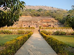
Nalanda district is fast developing and the ruins of the ancient Nalanda University or UNESCO Nalanda Archaeological Site attracts tourists from all over the world driving the local economy.

Economy

Agriculture is the backbone of the economy, with the majority of the population engaged in agriculture. Rice, wheat, maize, pulses, potato, fruits, and vegetables are the main crops. A newly setup Ordnance Factory, one of the 41 Indian Ordnance Factories has been set up by the Ministry of Defence, Government of India to manufacture artillery shells at Nalanda by the then Defence Minister Shri George Fernandes. Then there is the railway coach maintenance plant at Harnaut Block of Nalanda.

Tourism is well developed, with lakhs of people flocking at ruins of Nalanda University, Rajgir and Pawapuri. Rajgir was the first capital of Magadh Empire. Buddha had spent years at this place. Surrounded by five hills, it has got scenic views. Pawapuri, the Nirwana place of Mahavir, is holy place for the Jains. [15] [16] In 2006 the Ministry of Panchayati Raj named Nalanda one of the country's 250 most backward districts (out of a total of 640). [17] It is one of the 36 districts in Bihar currently receiving funds from the Backward Regions Grant Fund Programme (BRGF). [17]

Notable people

Related Research Articles

<span class="mw-page-title-main">Rajgir</span> Town in Bihar, India

Rajgir, meaning "The City of Kings," is a historic town in the district of Nalanda in Bihar, India. As the ancient seat and capital of the Haryanka dynasty, the Pradyota dynasty, the Brihadratha dynasty and the Mauryan Empire, as well as the dwelling ground of such historical figures as The Buddha and The Mahavira, the city holds a place of prominence in Hindu, Buddhist and Jain scriptures. As of 2011, the population of the town was reported to be 41,000 while the population in the community development block was about 88,500.

<span class="mw-page-title-main">Pawapuri</span> Town in Bihar, India

Pawapuri or Pavapuri is a holy site for Jains located in the Nalanda district of Bihar state in Eastern India. It is located about 19 kilometers from Rajgir and 101 kilometers from Patna, the capital of Bihar. Pawapuri is the place of Mahavira's nirvana and a pilgrimage site for Jains.

<span class="mw-page-title-main">Bihar Sharif</span> Sub-metropolitan city in Bihar, India

Bihar Sharif is the headquarters of Nalanda district and the fifth-largest sub-metropolitan area in the eastern Indian state of Bihar. Its name is a combination of two words: Bihar, derived from vihara, also the name of the state; and Sharif. The city is a hub of education and trade in southern Bihar, and the economy centers around agriculture supplemented by tourism, the education sector and household manufacturing. The ruins of the ancient Nalanda Mahavihara, a UNESCO World Heritage Site, are located near the city.

<span class="mw-page-title-main">Bakhtiarpur</span> City in Bihar, India

Bakhtiyarpur is a town and a municipality notified area, near Barh in Barh district in the state of Bihar, India. Bakhtiyarpur is under the Patna Sahib, and is a Vidhan Sabha constituency of Bihar in Barh District under the Barh sub-division of Bihar. It is a major railway junction in Danapur railway division, ECR. The incumbent Chief Minister of Bihar, Nitish Kumar belongs to Bakhtiyarpur.

Warisaliganj is a Community Development block and a Municipal Council in Nawada district in the Indian state of Bihar.

Islampur is a city and Notified area in Nalanda district in the Indian state of Bihar. it is a city council and no of ward is 26 here.

Hinduism is the most followed religion in Bihar, followed by nearly 82.7% of total population as per 2011 Census. Islam is the second-most followed religion which is followed by nearly 16.8% of population. There is also a significant population of Jains and Christians in the state.

<span class="mw-page-title-main">Harnaut</span> City in Bihar, India

Harnaut is a Nagar panchayat and corresponding Block in the Nalanda District of Bihar, India. The Hindu, Buddhist and Jain pilgrim centres of Nalanda, Pawapuri, Rajgir, Bodh Gaya and Vaishali are all near Harnaut. The incumbent Chief Minister of Bihar, Nitish Kumar, is from Kalyan Bigha village near Harnaut.

<span class="mw-page-title-main">Asthawan Assembly constituency</span> Constituency of the Bihar legislative assembly in India

Asthawan is one of 243 constituencies of the Bihar Legislative Assembly, in India. It is a part of Nalanda lok sabha constituency along with other assembly constituencies viz Islampur, Harnaut, Hilsa, Nalanda, Biharsharif and Rajgir.

<span class="mw-page-title-main">Biharsharif Assembly constituency</span> Constituency of the Bihar legislative assembly in India

Biharsharif Assembly constituency is one of 243 constituencies of legislative assembly of Bihar. It is a part of Nalanda Lok Sabha constituency along with other assembly constituencies viz. Islampur, Harnaut, Hilsa, Nalanda, Asthawan and Rajgir. In 2015 Bihar Legislative Assembly election, Biharsharif will be one of the 36 seats to have VVPAT enabled electronic voting machines.

<span class="mw-page-title-main">Rajgir, Bihar Assembly constituency</span> Vidhan Sabha constituency

Rajgir Assembly constituency is one of 243 constituencies of legislative assembly of Bihar. It is a part of Nalanda Lok Sabha constituency along with other assembly constituencies viz. Islampur, Harnaut, Hilsa, Nalanda, Asthawan and Biharsharif.

<span class="mw-page-title-main">Islampur, Bihar Assembly constituency</span> Legislative assembly of Bihar, India

Islampur Assembly constituency is one of 243 constituencies of legislative assembly of Bihar. It is a part of Nalanda Lok Sabha constituency along with other assembly constituencies viz. Rajgir, Harnaut, Hilsa, Nalanda, Asthawan and Biharsharif.

<span class="mw-page-title-main">Hilsa Assembly constituency</span> Constituency of the Bihar legislative assembly in India

Hilsa Assembly constituency is one of 243 constituencies of legislative assembly of Bihar. It is a part of Nalanda Lok Sabha constituency along with other assembly constituencies viz. Rajgir, Harnaut, Islampur, Nalanda, Asthawan and Biharsharif.

<span class="mw-page-title-main">Nalanda Assembly constituency</span> Legislative assembly in Bihar, India

Nalanda Assembly constituency is one of 243 constituencies of legislative assembly of Bihar. It is a part of Nalanda Lok Sabha constituency along with other assembly constituencies viz. Rajgir, Harnaut, Islampur, Hilsa, Asthawan and Bihar Sharif.

<span class="mw-page-title-main">Harnaut Assembly constituency</span> Constituency of the Bihar legislative assembly in India

Harnaut Assembly constituency is one of 243 constituencies of legislative assembly of Bihar. It is a part of Nalanda Lok Sabha constituency along with other assembly constituencies viz. Rajgir, Nalanda, Islampur, Hilsa, Asthawan and Biharsharif.

<span class="mw-page-title-main">Bihar Sharif Junction railway station</span> Railway junction station in Nalanda District, Bihar, India

Bihar Sharif Junction railway station, station code BEHS, is a railway station under Danapur railway division of East Central Railway. Bihar sharif is connected to metropolitan areas of India, by the Delhi–Kolkata main line via Mughalsarai–Patna route. Station is located in Bihar Sharif city in Nalanda district in the Indian state of Bihar. Due to its location on the Bakhtiyarpur–Tilaiya line, many trains from Patna and other cities via Bakhtiyarpur Junction, and trains coming from Rajgir and Gaya Junction stops here. Bihar Sharif has well connected trains running frequently to New Delhi, Patna Junction, Varanasi Junction, and Howrah Junction and with nearby cities Gaya Junction, Rajgir railway station, Tilaiya railway station, Bhagalpur railway station, Kiul Junction through daily passenger and express train services.

Rajgir–Danapur MEMU is a Mainline Electric Multiple Unit (MEMU) train of the Indian Railways connecting Rajgir in Bihar and Danapur in Bihar. It is currently being operated with 63339/63340 train numbers on daily basis.

<span class="mw-page-title-main">Patliputra University</span> University in India

Patliputra University (PPU) is a collegiate public state university located in Patna, Bihar, India. It was established by an act of the state legislature in 2018. As a collegiate university, its main functions are divided between the academic departments of the university and affiliated colleges.

<span class="mw-page-title-main">Giriyak</span> Town in Bihar, India

Giriyak is a village and community development block located on the bank of the Panchane River in Nalanda district of Bihar, India. It is located about 15 kilometres east of Rajgir, 26 kilometres south of Bihar Sharif, the district headquarters, and 95 kilometres southeast of Patna, the state capital.

<span class="mw-page-title-main">Kapildev Prasad Singh</span> Former Member of Bihar Legislative Council

Kapildev Prasad Singh. also known as Kapildeo Babu, was an Indian politician and a former member of the Bihar Legislative Council from Nalanda Local authority constituency. He also served as a chairperson of Nalanda district council of Bihar in establishment term of Panchayati Raj in 2001 to July 2003. He was joint to Bharatiya Janata Party in his early political career.

References

  1. "NALANDA Pin Code - 803111, Silao All Post Office Areas PIN Codes, Search NALANDA Post Office Address". ABP Live. Retrieved 28 July 2022.
  2. Chaudhary, Pranava Kumar (15 July 2016). "UNESCO declares Nalanda Mahavihara World Heritage Site". The Times of India. Retrieved 3 January 2021.
  3. "Sub-Divisions | District Nalanda, Government of Bihar | India". nalanda.nic.in. Retrieved 3 January 2021.
  4. "Districts of India". statoids.com. Retrieved 3 January 2021.
  5. Nitima Shiv Charan Dayawanti Srivastava (2010). "States and Union Territories: Bihar: Government". India 2010: A Reference Annual (54th ed.). New Delhi, India: Additional Director General, Publications Division, Ministry of Information and Broadcasting (India), Government of India. pp. 1118–1119. ISBN   978-81-230-1617-7.
  6. Indian Ministry of Forests and Environment. "Protected areas: Bihar". Archived from the original on 23 August 2011. Retrieved 25 September 2011.
  7. "Table A-02 Decadal Variation in Population Since 1901: Bihar" (PDF). census.gov.in. Registrar General and Census Commissioner of India.
  8. "Table C-01 Population by Religion: Bihar". censusindia.gov.in. Registrar General and Census Commissioner of India. 2011.
  9. 1 2 3 4 5 6 "District Census Handbook: Nalanda" (PDF). Census of India . Registrar General and Census Commissioner of India. 2011.
  10. Wordometer. "Country Comparison:Population" . Retrieved 1 October 2011. Mongolia 3,278,290 July 2011 est
  11. "2010 Resident Population Data". U. S. Census Bureau. Retrieved 30 September 2011. Kansas 2,853,118
  12. 1 2 "Table C-16 Population by Mother Tongue: Bihar". censusindia.gov.in. Registrar General and Census Commissioner of India. 2011.
  13. IANS (27 October 2015). "Caste dominates in Bihar's third round polling". Business Standard India. Retrieved 18 June 2019.
  14. कुमार, सुजीत (27 September 2020). "नीतीश कुमार का मजबूत दुर्ग है गृह जिला नालंदा, क्या सातों सीट जीतकर करेंगे क्लीन स्वीप?". Aaj Tak (in Hindi). Retrieved 21 June 2023.
  15. "Govt won't shift ordnance factory from Bihar - Times of India". articles.timesofindia.indiatimes.com. Archived from the original on 11 May 2013. Retrieved 17 January 2022.
  16. PTI (17 November 2017). "OFB Nalanda to develop indigenous artillery shells". @businessline. Retrieved 19 November 2020.
  17. 1 2 Ministry of Panchayati Raj (8 September 2009). "A Note on the Backward Regions Grant Fund Programme" (PDF). National Institute of Rural Development. Archived from the original (PDF) on 5 April 2012. Retrieved 27 September 2011.

25°12′00″N85°31′12″E / 25.20000°N 85.52000°E / 25.20000; 85.52000