
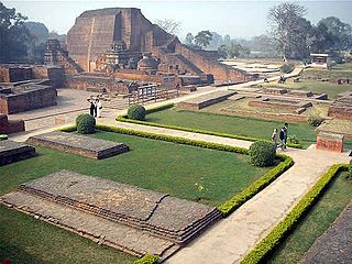
Nalanda was a renowned Buddhist mahavihara in ancient and medieval Magadha, eastern India. Widely considered to be among the greatest centers of learning in the ancient world, it was located near the city of Rajagriha, roughly 90 kilometres (56 mi) southeast of Pataliputra. Operating from 427 CE until the 13th century, Nalanda played a vital role in promoting the patronage of arts and academics during the 5th and 6th century CE, a period that has since been described as the "Golden Age of India" by scholars.
Vihāra generally refers to a Buddhist monastery for Buddhist renunciates, mostly in the Indian subcontinent. The concept is ancient and in early Sanskrit and Pali texts, it meant any arrangement of space or facilities for dwellings. The term evolved into an architectural concept wherein it refers to living quarters for monks with an open shared space or courtyard, particularly in Buddhism. The term is also found in Ajivika, Hindu and Jain monastic literature, usually referring to temporary refuge for wandering monks or nuns during the annual Indian monsoons. In modern Jainism, the monks continue to wander from town to town except during the rainy season (chaturmasya), and the term "vihara" refers to their wanderings.
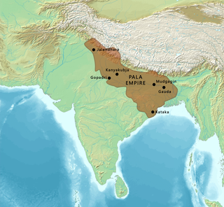
The Pāla Empire was an imperial power during the post-classical period in the Indian subcontinent, which originated in the region of Bengal. It is named after its ruling dynasty, whose rulers bore names ending with the suffix Pāla. The empire was founded with the election of Gopāla as the emperor of Gauda in late eighth century CE. The Pala stronghold was located in Bengal and eastern Bihar, which included the major cities of Gauḍa, Vikramapura, Pāṭaliputra, Monghyr, Somapura, Ramavati (Varendra), Tāmralipta and Jagaddala.
Buddhism, which originated in India, gradually dwindled and was replaced by approximately the 12th century. According to Lars Fogelin, this was "not a singular event, with a singular cause; it was a centuries-long process."

Vikramashila was a monastery in the Magadha region of modern-day Bihar in India. It was founded by King Dharmapala between the late eighth and early ninth century.

Bihar Sharif is the headquarters of Nalanda district and the fifth-largest sub-metropolitan area in the eastern Indian state of Bihar. Its name is a combination of two words: Bihar, derived from vihara, also the name of the state; and Sharif. The city is a hub of education and trade in southern Bihar, and the economy centers around agriculture supplemented by tourism, the education sector and household manufacturing. The ruins of the ancient Nalanda Mahavihara, a UNESCO World Heritage Site, are located near the city.

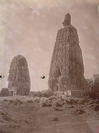
Odantapuri was a prominent Buddhist Mahavihara in what is now Bihar Sharif in Bihar, India. It is believed to have been established by the Pala ruler Gopala I in the 8th century. It is considered the second oldest of India's Mahaviharas after Nalanda and was situated in Magadha. Inscriptional evidence also indicates that the Mahavihara was supported by local Buddhist kings like the Pithipatis of Bodh Gaya.

Bharhut is a village located in the Satna district of Madhya Pradesh, central India. It is known for its famous relics from a Buddhist stupa. What makes Bharhut panels unique is that each panel is explicitly labelled in Brahmi characters mentioning what the panel depicts. The major donor for the Bharhut stupa was King Dhanabhuti.

Sculpture in the Indian subcontinent, partly because of the climate of the Indian subcontinent makes the long-term survival of organic materials difficult, essentially consists of sculpture of stone, metal or terracotta. It is clear there was a great deal of painting, and sculpture in wood and ivory, during these periods, but there are only a few survivals. The main Indian religions had all, after hesitant starts, developed the use of religious sculpture by around the start of the Common Era, and the use of stone was becoming increasingly widespread.

Somapura Mahavihara or Paharpur Buddhist Vihara in Paharpur, Badalgachhi, Naogaon, Bangladesh is among the best known Buddhist viharas or monasteries in the Indian Subcontinent and is one of the most important archaeological sites in the country. It was designated as a UNESCO World Heritage Site in 1985. It is one of the most famous examples of architecture in pre-Islamic Bangladesh. It dates from a period to the nearby Halud Vihara and to the Sitakot Vihara in Nawabganj Upazila of Dinajpur District.
A variety of ancient higher-learning institutions were developed in many cultures to provide institutional frameworks for scholarly activities. These ancient centres were sponsored and overseen by courts; by religious institutions, which sponsored cathedral schools, monastic schools, and madrasas; by scientific institutions, such as museums, hospitals, and observatories; and by respective scholars. They are to be distinguished from the Western-style university, an autonomous organization of scholars that originated in medieval Europe and has been adopted in other regions in modern times.
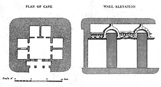
Telhara is a village in Ekangarsarai block of Nalanda district, in Bihar. It is also the site of the Telhara monastery which dates back to the 1st-century CE.
Mahavihara is the Sanskrit and Pali term for a great vihara and is used to describe a monastic complex of viharas.

The Kurkihar hoard is a set of 226 bronzes, mostly Buddhist, dating to between the 9th and 12th centuries CE, which were found in Kurkihar near Gaya in the Indian state of Bihar. The village of Kurkihar is situated about 5 km. north-east of Wazirganj, and 27 km east from Gaya. The inscriptions found suggest that Kurkihar was once a well known international pilgrimage center.
The Indian subcontinent has a long history of education and learning from the era of Indus Valley civilization. Important ancient institutions of learning in ancient India are Takshashila, Kashmir Smast, Nalanda, Valabhi University, Sharada Peeth, Pushpagiri Vihara, Odantapuri University, Vikramashila, Somapura Mahavihara, Bikrampur Vihara, Jagaddala Mahavihara.
The Pīṭhīpatis of Bodh Gaya were the rulers of the area around Bodh Gaya from roughly the 11th to 13th centuries in the Magadha region of what is now Bihar in India. Pithi refers to the diamond throne where the Buddha was said to have gained enlightenment.

Telhara was a Buddhist monastic establishment in Nalanda district of Bihar, India dating back to the 1st-century CE and active till at least the 12th-century CE. It is notable as it has been mentioned in the travelogues of Chinese monks including Xuanzang.

The Eight Great Events (aṣṭamahāpratihārya) are a set of episodes in the life of Gautama Buddha that by the time of the Pala Empire of North India around the 9th century had become established as the standard group of narrative scenes to encapsulate the Buddha's life and teachings. As such they were frequently represented in Buddhist art, either individually or as a group, and recounted and interpreted in Buddhist discourses.
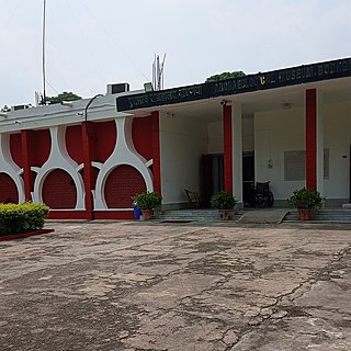
Archaeological Museum of Bodhgaya is a museum of archaeology in Bodhgaya, Bihar, India, located in close proximity to the Mahabodhi Temple complex. Established by the Archaeological Survey of India in 1956, it features several sculptures, artifacts and antiquities pertaining to Buddhism and Hinduism from 2nd century BC to 11th century CE, including some objects and coins from Mauryan, Gupta and Mughal periods.

Giriyak Stupa, also known as Jarasandha-ka-baithak, is an ancient cylindrical stupa located in the Nalanda district of Bihar, India.
