Gopalganj is one of the administrative districts in the Indian state of Bihar. The district headquarters is the town of Gopalganj, and the district is part of Saran Division. Major languages spoken are Bhojpuri, and Hindi.

Khagaria is a city in Indian state of Bihar and the administrative headquarters of Khagaria district. Khagaria is a part of Munger division. It is located at 25.5°N 86.48°E and has an average elevation of 36 metres (118 feet). The Khagaria Junction railway station serves the city.

Muzaffarpur is a city located in Muzaffarpur district in the Tirhut region of the Indian state of Bihar. It serves as the headquarters of Tirhut division, Muzaffarpur district and the Muzaffarpur Railway District. It is the fourth most populous city in Bihar.

Kishanganj district is one of the thirty-eight districts of Bihar state, India, and Kishanganj town is the administrative headquarters of this district. Kishanganj district is a part of Purnia division.
Siwan is a city and nagar parishad in the Indian state of Bihar. It is the administrative headquarters of Siwan district and one of the urban settlements out of three in the district. It is located close to Uttar Pradesh.
Aurangabad most often refers to:
Raxaul is a sub-divisional town in the East Champaran district of the Indian state of Bihar. It is situated on the India-Nepal border opposite Birgunj (Nepal). Raxaul is a major railway terminus.
Jainagar is a town and a notified area of Madhubani district in Bihar, India. It is situated on the holy Kamala River and has road and rail connections to Bihar's main cities Patna and to Nepal. The Jainagar is connected by Nepal Railways to Janakpur in Nepal. The local language is Maithili.
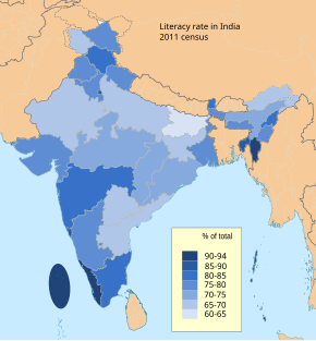
Literacy in India is a key for socio-economic progress, and the Indian literacy rate has grown to 74.04%. Despite government programmes, India's literacy rate increased only "sluggishly". The 2011 census, indicated a 2001–2011 decadal literacy growth of 9.2%, which is slower than the growth seen during the previous decade. An old 1990 study estimated that it would take until 2060 for India to achieve universal literacy at then-current rate of progress.

Sarnaism or Sarna, also known as Sariism or Adiism, is the indigenous religion of the Adivasi populations of the states of Jharkhand, Odisha, West Bengal, Bihar, Madhya Pradesh, Maharashtra and Chhattisgarh, centred around the worship of nature represented by trees. Followers of these religions primarily belong to the Munda, Ho, Bhumij, Santal, Baiga and Khuruk ethnic groups.
Basuari is a village+post in Madhubani district in the Indian state of Bihar india very good village of madhubani district in bihar of 60% population hase educated.
Motihari is a village in East Champaran district in the Indian state of Bihar.
Nautanwa is a village in West Champaran district in the Indian state of Bihar.
Ararah is a Gram panchayat in Hajipur in the Vaishali district, state of Bihar, India.
Daulat Pur Dewaria is a Gram Panchayat in Hajipur, Vaishali District, Bihar, India.
Thathan Buzurg is a village located in the Hajipur block of Vaishali district, Bihar, India. The Hajipur is the closest town and is 6 km from the village.
Badhauna is a village in Chandi Tehsil of Nalanda district in the Indian state of Bihar. The village falls under gram panchayat by the same name as the village. The village is about 54 kilometers of Patna of state capital Bihar and 1211 kilometers South-East of the national capital Delhi.
Nautan is a Community development block and a town of Siwan district in Indian state of Bihar. It is one out of 13 blocks of Siwan Subdivision.

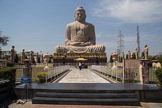
Deo is a town and a notified area in Aurangabad district in the Indian state of Bihar. It is the district's second-largest town in population after Aurangabad, from 2011. and also the second largest town in area. Deo is located 12 km away from the District Administration. Historically, the town was the centre of the Deo Raj zamindari estate. Deo is also known as Dev Town.