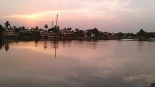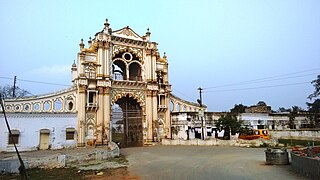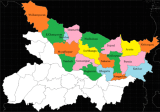
Munger, formerly spelt as Monghyr, is a twin city and a Municipal Corporation situated in the Indian state of Bihar. It is the administrative headquarters of Munger district and Munger Division. Munger was one of the major cities in Eastern India and undivided Bengal during Mughal period and British Raj. It is one of the major political, cultural, educational and commercial center of Bihar and Eastern India. Munger is situated about 180km from east of capital city Patna, about 480km west of Eastern India's largest city Kolkata and 1200km from country's capital New Delhi.
Madhepura is a municipality in Madhepura district in the Indian state of Bihar. It stands at the centre of Kosi ravine, It was called Madhyapura- a place centrally situated which was subsequently transformed as Madhipura into present Madhepura. It is surrounded by Araria and Supaul districts in the north, Khagaria and Bhagalpur districts in the south, Purnia district in the east and Saharsa district in the West.

Muzaffarpur is a city located in Muzaffarpur district in the Tirhut region of the Indian state of Bihar. It serves as the headquarters of the Tirhut division, the Muzaffarpur district and the Muzaffarpur Railway District.It is the fourth most populous city in Bihar.

Purnia is the fourth largest city of Bihar and is emerging as the largest economic hub in North Bihar. It serves as the administrative headquarters of both Purnia district and Purnia division in the Indian state of Bihar. It is well known for its favourable climate like Darjeeling and has an abundance of resources for human settlements and economic activities.

Saharsa is a city and municipal corporation in the Saharsa District in the eastern part of the state of Bihar, India. It is situated near the eastern banks of the Kosi River. It serves as the administrative headquarters for the Saharsa District and is also the Divisional headquarters of the Kosi Division.

Bettiah is a city and the administrative headquarters of West Champaran district - (Tirhut). It is near the Indo-Nepal border, 225 kilometres (140 mi) northwest of Patna, in the state of Bihar, India.

Katihar district is one of the thirty-eight districts of Bihar state in India, and Katihar city is the administrative headquarters of this district. The district is a part of Purnia Division. It is prominently known for its Katihar Junction Railway Station, which is a Category A1 station on the Barauni–Guwahati line. It has been included in the Aspirational Districts Program of the Government of India since 2018, to improve its socio-economic indicators. Katihar is the largest maize producing district of Bihar in 2022.
Banmankhi Bazar is a town and a notified area in Purnia district in the state of Bihar, India.

Bhanjanagar is a town and Municipality in Ganjam district in the state of Odisha, India.

Forbesganj is a city with municipality in the Araria District in the state of Bihar, India, situated at the border of Nepal.

Jogbani is a municipal council area, in Araria District of Bihar state, India. It lies on the Indo-Nepal border with Morang District, Koshi Zone and is a gateway to Biratnagar city. There is a customs checkpoint for goods at the border.

Padrauna is a city and headquarter of Kushinagar district in the Indian state of Uttar Pradesh. It is the place where Rama spent a few days of his life. After passing from Padrauna, Rama reached at Ramkola where he made a hut with his wife Sita and younger brother Lakshman to stay. It is situated 19 kilometres (12 mi) northeast of Kushinagar International Airport. Udit Narayan Intermediate College is the biggest College in the Kushinagar district.

Kasba is a satellite town of Purnia city and part of Purnia Urban Agglomeration in Purnia district in the Indian state of Mithila region of Bihar.

North Bihar is a term used for the region of Bihar, India, which lies north of the Ganga river.
Purnea Junction railway station, is the railway station serving the city of Purnea in the Purnea district in the Indian state of Bihar. It is a A category railway station of Katihar railway division in Northeast Frontier Railway.

Kolasi is a village situated near Katihar Town (5.0 km) of Bihar state in India. It is located on the banks of the Kosi river, surrounded by temples and agriculture lands and gathering a harmonized society above cast and religion. Generally, this village is known for having a common market place for nearby villages people and for its peaceful environment.

Katihar Medical College (KMC) is a medical college situated in the city of Katihar in the Indian state of Bihar. Katihar Medical College offers undergraduate courses in Bachelor of Medicine and Bachelor of Surgery (MBBS) and post-graduate courses in almost all Clinical and Non-Clinical Subjects. The college was established and is maintained by the Patna-based Al-Karim Educational Trust.
2017 Bihar floods affected 19 districts of North Bihar causing death of 514 people. 2,371 panchayats under 187 blocks of 19 districts of Northern Bihar have been affected in the flood. Around 1.71 crore people were hit by the floods. Over 8.5 lakhs of people have lost their homes, with Araria district alone accounting for 2.2 lakh homeless people. 2017 Flood has broken 9-Year record of deaths In Bihar. Bihar is India's most flood-prone State, with 76% of the population in the North Bihar living under the recurring threat of flood devastation. Devastating flood was caused due to excess heavy rainfall in monsoon season.

Purnea University is a collegiate public state university located in Purnia, Bihar, India. It has jurisdiction over Purnia, Araria, Kishanganj and Katihar districts. It was established by an act of State Legislature in 2018. As a collegiate university, its main functions are divided between the academic departments of the university and affiliated colleges.


