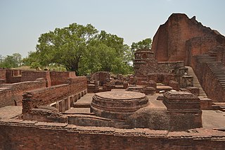
Bihar Sharif is the headquarters of Nalanda district and the fifth-largest sub-metropolitan area in the eastern Indian state of Bihar. Its name is a combination of two words: Bihar, derived from vihara, also the name of the state; and Sharif. The city is a hub of education and trade in southern Bihar, and the economy centers around agriculture supplemented by tourism, the education sector and household manufacturing. The ruins of the ancient Nalanda Mahavihara, a UNESCO World Heritage Site, are located near the city.

Patna district is one of the thirty-eight districts of Bihar state in eastern India. Patna, the capital of Bihar, is the district headquarters. The Patna district is a part of Patna division. The Patna district is divided into 6 Sub-divisions (Tehsils) i.e. Patna Sadar, Patna City, Barh, Masaurhi, Danapur and Paliganj.

Nawada district is one of the thirty-eight districts of the Indian state of Bihar. Nawada is its administrative headquarters. The district is the easternmost district of the Magadh division, one of the nine administrative divisions of Bihar. The area of the modern district was historically part of the Magadha, Shunga and Gupta empires. Koderma and Giridih districts of the state of Jharkhand lie on the southern border of the district; it also shares borders with the Gaya, Nalanda, Sheikhpura, and Jamui districts of Bihar.

Nalanda district is one of the thirty-eight districts of the state of Bihar in India. Bihar Sharif is the administrative headquarters of this district. The districts is home to the ancient Nalanda Mahavihara a UNESCO World Heritage Site. Nalanda is located in the Magadh region of southern Bihar.

Bakhtiyarpur is a town and a municipality notified area, near Patna City in Patna district in the state of Bihar, India. Bakhtiyarpur is under the Patna Sahib, and is a Vidhan Sabha constituency of Bihar in Patna District under the Barh sub-division of Bihar. It is a major railway junction in Danapur railway division, ECR. The incumbent Chief Minister of Bihar, Nitish Kumar belongs to Bakhtiyarpur.
Bikramganj is a nagar parishad city and community development block in Rohtas district, Bihar, India. In the 2011 census, Bikramganj had a population of nearly 4 lakh in 17,968 households. The main commodities produced in Bikramganj are rice and pulses. It has a slum known as Dhangai, which had a 2011 population of 3,955 in 637 households. Bikramganj is located at 25.2°N 84.25°E, and has an average elevation of 77 metres (252 feet).
Islampur is a city and Notified area in Nalanda district in the Indian state of Bihar. it is a city council and no of ward is 26 here.

Kundalpur is a village in Nalanda district in the Indian state of Bihar. It is located about 2.5 kilometres from ancient Nalanda Mahavihara, 11 kilometres southwest of Bihar Sharif, and 80 kilometres southeast of Patna.
Simaria is a community development block that forms an administrative division in the Simaria subdivision of the Chatra district, Jharkhand state, India.
Chatra is a community development block that forms an administrative division in the Chatra subdivision of the Chatra district in the Indian state of Jharkhand.
Shaligram Ramnarayanpur (Hunterganj) is a community development block that forms an administrative division in the Chatra subdivision of the Chatra district in the Indian state of Jharkhand.
Deoghar is a community development block that forms an administrative division in the Deoghar subdivision, of the Deoghar district, Jharkhand state, India.
Karon is a community development block that forms an administrative division in the Madhupur subdivision of the Deoghar district, Jharkhand state, India.
Kankjol is a village in Barharwa block of Sahibganj district, Jharkhand. An old town dating back at least to the 1100s, Kankjol was a provincial capital under the Sena dynasty and later was the seat of a pargana under the Mughal Empire. As of 2011, it has a population of 2,501 people, in 514 households.

Giriyak is a village and community development block located on the bank of the Panchane River in Nalanda district of Bihar, India. It is located about 15 kilometres east of Rajgir, 26 kilometres south of Bihar Sharif, the district headquarters, and 95 kilometres southeast of Patna, the state capital.
Unwal, also called Sangrampur or Kasba Sangrampur and possibly also Unaula, is a large village in Bansgaon block of Gorakhpur district, Uttar Pradesh. It may also be identical with the Oṇavala mentioned in two Gāhaḍavāla-era copper plate grants from the early 1100s. The pargana of Unaula may be named after Unwal. As of 2011, it has a population of 17,377, in 2,460 households.
Unaula Khas, also just Unaula, is a village in Khajni block of Gorakhpur district, Uttar Pradesh. It may be identical with the Oṇavala mentioned in two Gāhaḍavāla-era copper plate grants from the early 1100s. As of 2011, it has a population of 1,078, in 136 households.
Maniawan is a village in Silao subdistrict of Nalanda district, Bihar. As of 2011, it has a population of 5,368, in 918 households.
Ben is a village and corresponding community development block of Nalanda district, Bihar. As of 2011, it has a population of 6,525, in 1,144 households.
Ghantoli is a small agricultural village in Sankheda taluka of Chhota Udaipur district, Gujarat. It dates back to at least 1045, when it is mentioned in a copper plate inscription recording a land grant made to the local temple to the god Ghaṇṭeśvara. The temple still exists in ruins. There is also a train station in the village. As of 2011, Ghantoli has a population of 408, in 82 households. Most of the locals are employed in agriculture.


