Mount Everest, known locally as Sagarmatha or Qomolangma, is Earth's highest mountain above sea level, located in the Mahalangur Himal sub-range of the Himalayas. The China–Nepal border runs across its summit point. Its elevation of 8,848.86 m was most recently established in 2020 by the Chinese and Nepali authorities.

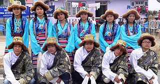
The Sherpas are one of the Tibetan ethnic groups native to the most mountainous regions of Nepal and Tibetan Autonomous Region of China.

Lhotse is the fourth-highest mountain on Earth, after Mount Everest, K2, and Kangchenjunga. At an elevation of 8,516 metres (27,940 ft) above sea level, the main summit is on the border between Tibet Autonomous Region of China and the Khumbu region of Nepal.

Pumori is a mountain on the Nepal-China border in the Mahalangur section of the Himalayas. Pumori lies just eight kilometres west of Mount Everest. Pumori, meaning "the Mountain Daughter" in Sherpa language, was named by George Mallory. "Pumo" means young girl or daughter and "Ri" means mountain in Sherpa language. Climbers sometimes refer to Pumori as "Everest's Daughter". Mallory also called it Clare Peak, after his daughter.

Ama Dablam is a mountain in the eastern Himalayan range of Koshi Province, Nepal. The main peak is 6,812 metres (22,349 ft), the lower western peak is 6,170 metres (20,243 ft). Ama Dablam means "mother's necklace"; the long ridges on each side like the arms of a mother (ama) protecting her child, and the hanging glacier thought of as the dablam, the traditional double-pendant containing pictures of the gods, worn by Sherpa women. For several days, Ama Dablam dominates the eastern sky for anyone trekking to Mount Everest Base Camp. For its soaring ridges and steep faces Ama Dablam is sometimes referred as the "Matterhorn of the Himalayas." The mountain is featured on the one rupee Nepalese banknote.

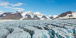
A crevasse is a deep crack that forms in a glacier or ice sheet. Crevasses form as a result of the movement and resulting stress associated with the shear stress generated when two semi-rigid pieces above a plastic substrate have different rates of movement. The resulting intensity of the shear stress causes a breakage along the faces.

The Khumbu Glacier is located in the Khumbu region of northeastern Nepal between Mount Everest and the Lhotse-Nuptse ridge. With elevations of 4,900 m (16,100 ft) at its terminus to 7,600 m (24,900 ft) at its source, it is the world's highest glacier. The Khumbu Glacier is followed for the final part of the trail to one of the Everest Base Camps. The start of the glacier is in the Western Cwm near Everest. The glacier has a large icefall, the Khumbu Icefall, at the west end of the lower Western Cwm. This icefall is the first major obstacle—and among the more dangerous—on the standard south col route to the Everest summit. It is also the largest glacier in Nepal.

An icefall is a portion of certain glaciers characterized by relatively rapid flow and chaotic crevassed surface, caused in part by gravity. The term icefall is formed by analogy with the word waterfall, which is a similar phenomenon of the liquid phase but at a more spectacular speed. When ice movement of a glacier is faster than elsewhere, because the glacier bed steepens or narrows, and the flow cannot be accommodated by plastic deformation, the ice fractures, forming crevasses. Where two fractures meet, seracs can be formed. When the movement of the ice slows down, the crevasses can coalesce, resulting in the surface of the glacier becoming smoother.

A serac is a block or column of glacial ice, often formed by intersecting crevasses on a glacier. Commonly house-sized or larger, they are dangerous to mountaineers, since they may topple with little warning. Even when stabilized by persistent cold weather, they can be an impediment to glacier travel.

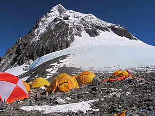
There are two base camps on Mount Everest, on opposite sides of the mountains: South Base Camp is in Nepal at an altitude of 5,364 metres (17,598 ft), while North Base Camp is in Tibet at 5,150 metres (16,900 ft).

Pheriche is a village in the Khumbu region of eastern Nepal. Situated at an altitude of about 4,371 m (14,340 ft), above the Tsola River, Pheriche is a popular stop for trekkers and climbers. There is a rudimentary hospital in Pheriche managed by the Himalayan Rescue Association. The Pheriche hospital is open only during the two trekking/climbing seasons. Although the hospital was built with Japanese support in 1975, it is staffed by Nepalis and volunteer physicians who are mostly from the US, Europe, Canada and Australia.

The 1970 Mt. Everest disaster is the term for the avalanche death of six Nepalese Sherpa porters on 5 April 1970, who were killed on the Khumbu Icefall of Mount Everest while assisting the Japanese Everest Skiing Expedition 1970 climbing expedition. Four days later Sherpa Kyak Tsering, a porter on a different Japanese Mt. Everest expedition, was killed by ice falling from a serac. Later, Yūichirō Miura, the focus of the film expedition, became the first person to attempt to successfully ski down Everest.

On 18 April 2014, seracs on the western spur of Mount Everest failed, resulting in an ice avalanche that killed sixteen climbing Sherpas in the Khumbu Icefall. This was the same icefall where the 1970 Mount Everest disaster had taken place. Thirteen bodies were recovered within two days, while the remaining three were never recovered due to the great danger in attempting such an expedition. Many Sherpas were angered by what they saw as the Nepalese government's meager offer of compensation to victims' families, and threatened a protest or strike. On 22 April, the Sherpas announced they would not work on Everest for the remainder of 2014 as a mark of respect for the victims.

The Lho La is a col on the border between Nepal and Tibet north of the Western Cwm, near Mount Everest. It is at the lowest point of the West Ridge of the mountain at a height of 6,006 metres (19,705 ft). It is not exactly a Pass, but a part of Mt. Everest Range. There was once a proposal, which failed, to change its name to Khumbu La.

Lingtren, 6,749 metres (22,142 ft), is a mountain in the Mahalangur Himal area of Himalaya, about 8 kilometres (5.0 mi) distant in a direct line from Mount Everest. It lies on the international border between Nepal and the Tibet Autonomous Region of China and it was first climbed in 1935. A mountain nearby to the west was originally named Lingtrennup but is now more commonly called Xi Lingchain.

In the afternoon of 25 April 2015, a MW 7.8 earthquake struck Nepal and surrounding countries. Tremors from the quake triggered an avalanche from Pumori into Base Camp on Mount Everest. At least twenty-two people were killed, surpassing the toll of an avalanche that occurred in 2014 as the deadliest disaster on the mountain.
The 1951 British Mount Everest reconnaissance expedition ran between 27 August 1951 and 21 November 1951 with Eric Shipton as leader.

The Mount Everest climbing season of 2013 included 658 summits and 8 deaths. Due to avalanches in 2014 and 2015, this was the last big summiting year until 2016.

Mount Everest climbing season included 245 summits on May 19, 2012, a record number of summits on a single day. It would take seven more years to break this record. This added congestion resulted in the highest fatality total since 1996. 683 climbers from 34 countries attempted to climb the mountain, and 547 people summited. A record was set in May when 234 climbers summitted on a single day. There were 11 deaths, some of which were attributed to overcrowding near the peak.


