
The Ghaghara River, called Karnali River in Nepal, Mapcha Tsangpo in Tibet, and the lower Ghaghara in Awadh called Sarayu River, is a perennial trans-boundary river that originates in the northern slopes of the Himalayas in the Tibetan Plateau, cuts through the Himalayas in Nepal and joins the Sharda River at Brahmaghat in India. Together they form the Ghaghara River, a major left-bank tributary of the Ganges. With a length of 507 km (315 mi), it is the longest river in Nepal. The total length of the Ghaghara up to its confluence with the Ganges at Revelganj in Bihar is 1,080 km (670 mi). It is the largest tributary of the Ganges by volume and the second largest by length after Yamuna.

The Terai or Tarai is to a lowland region in parts of northern India and southern Nepal that lies to the south of the outer foothills of the Himalayas, the Sivalik Hills and north of the Indo-Gangetic Plain. This lowland belt is characterised by tall grasslands, scrub savannah, sal forests and clay rich swamps. In North India, the Terai spreads from the Yamuna River eastward across Haryana, Uttarakhand, Uttar Pradesh, Bihar and West Bengal. The Terai is part of the Terai-Duar savanna and grasslands ecoregion. Nepal's Terai stretches over 33,998.8 km2 (13,127.0 sq mi), about 23.1% of Nepal's land area, and lies at an elevation of between 67 and 300 m. The region comprises more than 50 wetlands. North of the Terai rises the Bhabar, a narrow but continuous belt of forest about 8–12 km (5.0–7.5 mi) wide.

Banke District (Nepali: बाँके जिल्ला, romanized: Bām̐kē jillā;, a part of Lumbini Province, is one of the 77 districts of Nepal. The district, located in midwestern Nepal with Nepalganj as its district headquarters, covers an area of 2,337 km2 and had a population of 385,840 in 2001 and 491,313 in 2011. There are three main cities in the Banke District: Nepalganj, Kohalpur and Khajura Bajaar.

Bardiya District, one of the seventy-seven Districts of Nepal, is part of Lumbini Province of Nepal. The district, with Gulariya as its headquarters, covers an area of 2,025 km2 (782 sq mi) and according to the 2001 census the population was 382,649 in 2011 it has 426,576.
Surkhet District is a district in Karnali Province of mid-western Nepal. Surkhet is one of the ten districts of Karnali located about 600 kilometres (373 mi) west of the national capital Kathmandu. The district's area is 2,489 square kilometres (961 sq mi). It had 288,527 population in 2001 and 350,804 in 2011 which male comprised 169,461 and female 181,381. Its district headquarters, Birendranagar, is the capital of Karnali Province. It is serving as a business hub and document center for Karnali province. According to population, development, road links, landforms, climate, many peoples are migrating here. After becoming province capital developmental activities are boosted and are in peak level. All the governmental works are carried here. Birendranagar is beautiful valley surrounded by hills having moderate climate.

Doti, also known as Doti region, Dotigarh (डोटीगढ़) as used in the Jagar, in the Farwestern region of Nepal, is a region situated between River Kali bordering Kumaon division of Uttarakhand, India in the west and the Karnali river on the east. Doti was one of eight different princely states of the Katyuri Kingdom.

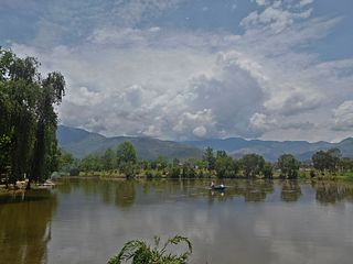
Bardiya National Park is a protected area in Nepal that was established in 1988 as Royal Bardia National Park. Covering an area of 968 km2 (374 sq mi) it is the largest and most undisturbed national park in Nepal's Terai, adjoining the eastern bank of the Karnali River and bisected by the Babai River in the Bardiya District. Its northern limits are demarcated by the crest of the Siwalik Hills. The Nepalgunj-Surkhet highway partly forms the southern boundary, but seriously disrupts the protected area. Natural boundaries for human settlements are formed in the west by the Geruwa, a branch of the Karnali River, and in the southeast by the Babai River.

Mahendra Highway, also called East-West Highway, runs across the Terai geographical region of Nepal, from Mechinagar in the east to Bhim Datta in the west, cutting across the entire width of the country. It is the longest highway in Nepal and was constructed in cooperation with various countries. The highway is named after King Mahendra Shah.

The Far-Western Development Region was one of Nepal's five development regions. It was located at the western end of the country and had its headquarters in Dipayal.
Chisapani is a village in Banke District in Lumbini Province of south-western Nepal, not to be confused with Chisapani in the bank of Karnali River.
Manpur Tapara is a town and marketplace in Rajapur Municipality in Bardiya District in the Bheri Zone of south-western Nepal. The former village development committee (VDC) was merged with Daulatpur, Naya Gaun, Badalpur, Bhimapur and Rajapur VDCs to form the new municipality on 18 May 2014. It is almost at the centre of river island called Bhawara Tappu of Karnali River.
The Mid-Western Development Region was one of the largest and formerly one of Nepal's five development regions. Westward from the Central region surrounding Kathmandu were the Western, Mid-Western and finally Far-Western regions. Counter-intuitively, Mid-Western lay west of Western.

The Tharu or Tharuhat languages are any of the Indo-Aryan languages spoken by the Tharu people of the Terai region in Nepal, and neighboring regions of Uttarakhand, Uttar Pradesh and Bihar in India.
Lamki Chuha is a municipality in Kailali District in Sudurpashchim Province of Nepal established on 18 May 2014 by merging Baliya and Chuha, two existing village development committees. Later in May 8, 2014 it was formed by merging all the ward of Pratappur Village development committee. Lamki Chuha lies 72 kilometres (45 mi) east of Dhangadhi and 590 km (370 mi) west of the capital, Kathmandu. It is surrounded by Bardagoriya Rural Municipality and Joshipur Rural Municipality in the West, Bardiya District in the East, Mohanyal Rural Municipality in the North and Janaki Rural Municipality in the South. Its Municipal office is located at Lamki chuha 2 Bhalka, Kailali.

Hilsa is a village in the northwestern corner of Nepal bordering Tibet Autonomous Region (China), where the Humla Karnali crosses from the Tibetan Plateau into the mountain regions on its descent to the Ganges. Hilsa is in Humla District, Karnali Zone facing Burang County, Ngari Prefecture, Tibet region of China.

The Dodhara Chandani Bridge, commonly known as Mahakali Bridge is a suspension bridge for pedestrians and at this point only about 1452.5 m long over Mahakali River in the far west of Nepal.

Sudurpashchim Province is one of the seven provinces established by the new constitution of Nepal which was adopted on 20 September 2015. It borders the Tibet Autonomous Region of China to the north, Karnali Province and Lumbini Province to the east, and India's states of Uttarakhand and Uttar Pradesh to the west and south, respectively. The province covers an area of 19,539 km2, or about 13.22% of the country's total area.
Rani Jamara Kulariya Irrigation Project is one of the National Pride Projects of Nepal located in Kailali district. The intake of the project is located in Chisapani in the Karnali River. The project has an incremental history with multiple phases. The first initiation was done in 1953BS by Rani Padam Kumari Shah with a command area of 4,000 ha which was named Rani kulo pranali. The command area was increased by 3700 ha in 1960 BS by Dhundi Raj Sahi that was named Jamara kulo pranali. In 1972BS, 3300 ha was added by Madhu Mahato with name of Kulriya kulo pranali. The project was included National Pride Project in 2066 BS. with an aim to develop canal system to cover a command area of 20,300 ha. along with the construction of an agricultural road.
The Karnali River Bridge was designed by Steinman, a firm that was later incorporated into the Parsons Corporation, USA. Kawasaki Heavy Industries constructed the bridge.


