Major road and railway bridges
This table presents the structures with spans greater than 100 meters (non-exhaustive list).
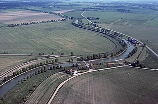
This is a list of bridges and viaducts in Sweden, including those for pedestrians and vehicular traffic.
This table presents the structures with spans greater than 100 meters (non-exhaustive list).
| Name | Length (m) | Span(m) | Type of traffic | Opened |
|---|---|---|---|---|
| Øresund Bridge | 7 845; 5300 m in Sweden | 490 | Road/Railway | 2000 |
| Öland Bridge | 6 072 | 130 | Road | 1972 |
| Igelsta Bridge | 2 140 | Railway | 1995 | |
| Sundsvall Bridge | 2 109 | 170 | Road | 2014 |
| Umeälvsbron | 1 938 | Railway | 2010 | |
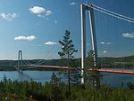
| Höga Kusten Bridge | 1 867 | 1 210 | Road | 1997 |
| Uddevalla Bridge | 1 712 | 414 | Road | 2000 |
| Vallsundsbron | 1 500 | Road | 1998 | |
| Stallbackabron | 1 392 | 124 | Road | 1981 |
| Sannsundsbron | 1 322 | Road | 1981 | |
| Kista bridge | ≈1 200 | Metro | 1977 | |
| Strängnäsbron | 1 164 | Road | 1981 | |
| Partihallsförbindelsen | ≈1 150 | Road | 2011 | |
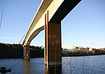
| Alnöbron | 1 042 | 134 | Road | 1964 |
| Ångermanälven bridge | 1 035 | Railway | 2008 | |
| Nätraån bridge | 1 014 | Railway | 2008 | |
| Hjulstabron | ≈1000 | Road | 1953 | |
| Lidingöbron | 997 | 73 | Road | 1971 |
| Obbola Bridge | 979 | Road | 1989 | |
| Nordreälvsbron | 956 | Road | 1968 | |
| Göta älvbron | 950 | Road/Tramway/Bike path | 1939 | |
| Älvsborg Bridge | 933 | 418 | Road/Bike path | 1966 |
| Angeredsbron | 930 | Road/Bike path | 1978 | |
| Marieholmsbron | 907 | Railway/Bike path | 1996 | |
| Bergnäsbron | 896 | Road | 1954 | |
| Västra Årstabron | 833 | Railway/Bike path | 2005 | |
| Sandö Bridge | 811 | 264 | Road | 1943 |
| Älandsfjärdenbron | 785 | Railway | 2011 | |
| Sölvesborgsbron | 760 | Walk/Bike path | 2012 | |
| Johanneshovsbron | 756 | 56 | Road | 1984 |
| Östra Årstabron | 753 | 151 | Railway | 1929 |
| Old Lidingöbron | 750 | 140 | Railway/Bike path | 1925 |
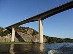
| Svinesund Bridge | 704, about half in Sweden | 247 | Road | 2005 |
| Kolbäck Bridge | 700 | 103 | Road | 2001 |
| Rödöbron | 677 | Road | 1993 | |
| Almö Bridge | 667 | 278 | 1960 | |
| Tjörn Bridge | 664 | 366 | Road/Bike path | 1981 |
{{cite web}}: CS1 maint: multiple names: authors list (link)| Structural types |
|  |
|---|---|---|
| Lists of bridges by type | ||
| Lists of bridges by size | ||
| Additional lists | ||
| Related | ||

Örnsköldsvik Municipality is one of Sweden's 290 municipalities, in Västernorrland County in northern Sweden. Its seat is in the town Örnsköldsvik. The present municipality was created in 1971 by the amalgamation of the City of Örnsköldsvik with seven former rural municipalities.

The Øresund or Öresund Bridge is a combined railway and motorway bridge across the Øresund strait between Denmark and Sweden. It is the longest in Europe with both roadway and railway combined in a single structure, running nearly 8 kilometres from the Swedish coast to the artificial island Peberholm in the middle of the strait. The crossing is completed by the 4-kilometre (2.5 mi) Drogden Tunnel from Peberholm to the Danish island of Amager.

A cable-stayed bridge has one or more towers, from which cables support the bridge deck. A distinctive feature are the cables or stays, which run directly from the tower to the deck, normally forming a fan-like pattern or a series of parallel lines. This is in contrast to the modern suspension bridge, where the cables supporting the deck are suspended vertically from the main cable, anchored at both ends of the bridge and running between the towers. The cable-stayed bridge is optimal for spans longer than cantilever bridges and shorter than suspension bridges. This is the range within which cantilever bridges would rapidly grow heavier, and suspension bridge cabling would be more costly.
The High Coast is a part of the coast of Sweden on the Gulf of Bothnia, in the Ångermanland province of northeast Sweden, centered in the area of the municipalities of Kramfors, Härnösand, Sollefteå and Örnsköldsvik. It is notable as an area for research on post-glacial rebound and eustacy, in which the land rises as the covering glaciers melt, a phenomenon first recognised and studied there. Since the last ice age, the land has risen 300 meters, which accounts for the region's unusually tall cliffs. The High Coast is part of the Swedish/Finnish High Coast/Kvarken Archipelago UNESCO World Heritage Site because of its exceptional geology and unique example of isostatic rebound.

The Bothnia Line is a high-speed railway line in northern Sweden. The 190 km (118 mi) long route, from Höga Kusten Airport, where it connects to the Ådalen Line, via Örnsköldsvik to Umeå, was opened in 2010 and trains are allowed to travel at speeds up to 250 km/h (155 mph). Although, no train with a higher top speed than 200 km/h (125 mph) uses the railway as of 2023.
NextJet was one of the largest regional airlines in Sweden. It was headquartered in Frösundavik in Solna Municipality, just north of Stockholm. The airline filed for bankruptcy on 16 May 2018, half a year after one of its planes was believed to be sabotaged.
Höga Kusten Airport, translated High Coast Airport, is an airport situated between the localities Kramfors and Sollefteå in Sweden. To the Swedish Aeronautical Information Publication the airport is known as Kramfors-Sollefteå Airport. The airport is named Kramfors on tickets and flight lists on other airports.

Alnö is an island in the Gulf of Bothnia just outside Sundsvall in Medelpad, Sweden. It has an area of 67.79 km2 and a permanent population of 8,417, although its summertime inhabitants are about twice that number. Most of the island's inhabitants work in Sundsvall and other towns on the mainland.

The Air Defence Regiment, is the only anti-aircraft regiment in the Swedish Armed Forces. Its new organisation was introduced in 2000, when all other anti-aircraft units in Sweden were disbanded. The regiment is located in Halmstad and has the responsibility for training two air defence battalions and one home guard battalion.

Lilla Bommen is a part of Gothenburg harbor used for visiting boats and also the name given to the land surrounding the harbor. The eponymous building along with The Göteborg Opera house and the barque Viking are all located at Lilla Bommen.