List of bridges in Hungary

Last updated

This list of bridges in Hungary lists bridges of particular historical, scenic, architectural or engineering interest. Road and railway bridges, viaducts, aqueducts and footbridges are included.

Contents

Major road and railway bridges

This table presents the structures with spans greater than 100 meters (non-exhaustive list).

NameHungarianSpanLengthTypeCarries
Crosses
OpenedLocationRegionRef.
Dunaujvaros, Pentele hid legi felvetelen.jpg 1 Pentele Bridge Dunaújvárosi híd308 m (1,010 ft)1,670 m (5,480 ft) Arch
Steel tied arch
Bow-string bridge
2007 Dunaújváros Dunavecse
46°54′12.0″N18°57′29.7″E / 46.903333°N 18.958250°E / 46.903333; 18.958250 (Pentele Bridge)
Central Transdanubia
Southern Great Plain
[S 1]
[1]
Civertanmegyeri4.jpg 2 Megyeri Bridge Megyeri híd300 m (980 ft)1,862 m (6,109 ft) Cable-stayed
Steel girder deck, concrete pylons
145+300+145
M0 motorway
Budapest Ring Road
4 lanes
Danube
2008 Budapest
47°36′26.6″N19°05′32.6″E / 47.607389°N 19.092389°E / 47.607389; 19.092389 (Megyeri Bridge)
Central Hungary [S 2]
[B 1]
[2]
Erzsebet Bridge (1903), Budapest, Hungary.jpg 3 Elisabeth Bridge (1903)
destroyed in 1945
Erzsébet híd290 m (950 ft)379 m (1,243 ft) Suspension
Chain bridge
1903 Budapest
1st - 5th
47°29′27.2″N19°02′56.7″E / 47.490889°N 19.049083°E / 47.490889; 19.049083 (Elisabeth Bridge (Budapest)(1903))
Central Hungary [S 3]
[B 2]
[3]
Bridge over the Danube at Budapest -c.jpg 4 Elisabeth Bridge Erzsébet híd290 m (950 ft)380 m (1,250 ft) Suspension
Steel girder deck, steel pylons
6 lanes road bridge
Danube
1964 Budapest
1st - 5th
47°29′27.4″N19°02′57.2″E / 47.490944°N 19.049222°E / 47.490944; 19.049222 (Elisabeth Bridge (Budapest))
Central Hungary [S 4]
[B 2] [3]
Monostor Bridge.jpg 5 Monoštor Bridge  [ hu ]Monostori híd252 m (827 ft)600 m (2,000 ft) Cable-stayed
Steel girder deck, steel pylon
2 lanes road bridge
Danube
2020 Komárom Komárno
47°45′23.5″N18°05′04.9″E / 47.756528°N 18.084694°E / 47.756528; 18.084694 (Monoštor Bridge)
Central Transdanubia
Flag of Slovakia.svg  Slovakia
[4]
Lanchid (17. szamu muemlek) 22.jpg 6 Széchenyi Chain Bridge Széchenyi Lánchíd202 m (663 ft)380 m (1,250 ft) Suspension
Chain bridge, wrought iron deck, masonry pylons
89+202+89
2 lanes road bridge
Danube
1849 Budapest
5th
47°29′56.3″N19°02′36.7″E / 47.498972°N 19.043528°E / 47.498972; 19.043528 (Széchenyi Chain Bridge)
Central Hungary [S 5]
[B 3]
[5]
Szabadsag Bridge 2010.JPG 7 Liberty Bridge (Budapest) Szabadság híd179 m (587 ft)337 m (1,106 ft) Truss
Steel
79+179+79
2 lanes road bridge
Trams in Budapest
(lines 2, 2B, 2M)
Danube
1896 Budapest
5th - 11th
47°29′08.7″N19°03′17.7″E / 47.485750°N 19.054917°E / 47.485750; 19.054917 (Liberty Bridge (Budapest))
Central Hungary [S 6]
[B 4]
[6]
Budapest Petofi Bridge.jpg 8 Petőfi Bridge Petőfi híd154 m (505 ft)514 m (1,686 ft) Truss
Steel
112+154+112
4 lanes road bridge
Trams in Budapest
(lines 4, 6)
Danube
1937 Budapest
5th - 11th
47°28′43.9″N19°03′48.2″E / 47.478861°N 19.063389°E / 47.478861; 19.063389 (Petőfi Bridgei)
Central Hungary [S 7]
[B 5]
[7]
Tisza-szeged1.jpg 9 Belvárosi Bridge Belvárosi híd147 m (482 ft) Arch
Steel tied arch
Bow-string bridge
2 lanes road bridge
Tisza
1948 Szeged
46°15′03.1″N20°09′12.1″E / 46.250861°N 20.153361°E / 46.250861; 20.153361 (Belvárosi Bridge (Szeged))
Southern Great Plain [S 8]
Szeged Uj hid ujszegedi oldal.JPG 10 Bertalan Bridge  [ hu ]Bertalan híd141 m (463 ft)762 m (2,500 ft) Beam bridge
Steel
1979 Szeged
46°15′21.8″N20°09′54.3″E / 46.256056°N 20.165083°E / 46.256056; 20.165083 (Bertalan Bridge)
Southern Great Plain [S 9]
Dunafoldvar-Dunahid2-a.jpg 11 József Beszédes Bridge  [ hu ]Beszédes József híd136 m (446 ft)(x2)509 m (1,670 ft) Truss
Steel
109+2x136+109
Main road 52
2 lanes
Danube
1930 Dunaföldvár Solt
46°48′37.9″N18°55′59.3″E / 46.810528°N 18.933139°E / 46.810528; 18.933139 (József Beszédes Bridge)
Southern Transdanubia
Southern Great Plain
[8]
Nagyhid Medvenel.jpg 12 Vámosszabadi Bridge  [ hu ]Vámosszabadi híd133 m (436 ft)363 m (1,191 ft) Truss
Steel
114+133+114
1942 Vámosszabadi Medveďov
47°47′36.5″N17°39′05.4″E / 47.793472°N 17.651500°E / 47.793472; 17.651500 (Vámosszabadi Bridge)
Western Transdanubia
Flag of Slovakia.svg  Slovakia
[9]
Szent Laszlo hid a magasbol.jpg 13 Szent László Bridge  [ hu ]Szent László híd120 m (390 ft)(x3)917 m (3,009 ft) Box girder
Steel
80+3x120+80
M9 motorway
2 lanes
Danube
2003 Szekszárd
46°21′08.1″N18°53′43.9″E / 46.352250°N 18.895528°E / 46.352250; 18.895528 (Szent László Bridge)
Southern Transdanubia [10]
Koroshegyi volgyhid.jpg 14 Kőröshegyi Viaduct  [ hu ]Kőröshegyi völgyhíd120 m (390 ft)(x13)1,872 m (6,142 ft) Box girder
Prestressed concrete
95+13x120+95
2007 Kőröshegy
46°48′59.8″N17°54′07.3″E / 46.816611°N 17.902028°E / 46.816611; 17.902028 (Kőröshegyi Viaduct)
Southern Transdanubia [S 10]
[11]
Maria-Valeria-Brucke, Esztergom 01.jpg 15 Mária Valéria Bridge Mária Valéria híd119 m (390 ft)514 m (1,686 ft) Truss
Steel
85+102+119+102+85
2 lanes road bridge
Danube
1895 Esztergom Štúrovo
47°47′43.0″N18°43′47.6″E / 47.795278°N 18.729889°E / 47.795278; 18.729889 (Mária Valéria Bridge)
Central Transdanubia
Flag of Slovakia.svg  Slovakia
[S 11]
[12]
Harosi M0-as Duna-hid2.jpg 16 Deák Ferenc Bridge  [ hu ]Deák Ferenc híd108 m (354 ft)(x3)770 m (2,530 ft) Box girder
Steel
Twin bridges
3x73+3x10⁸+3x73
M0 motorway
8 lanes
Budapest Ring Road
Danube
1990
2013
Budapest 22nd Szigetszentmiklós
47°23′20.6″N19°00′50.1″E / 47.389056°N 19.013917°E / 47.389056; 19.013917 (Deák Ferenc Bridge)
Central Hungary [13]
Arpadhid.jpg 17 Árpád Bridge Árpád híd103 m (338 ft)(x2)928 m (3,045 ft) Beam bridge
Steel
82+103+103+82
76+102+76
6 lanes road bridge
Trams in Budapest
(lines 1, 1M, 17, 41)
Danube
1950 Budapest
2nd - 13th
47°32′14.8″N19°03′14.9″E / 47.537444°N 19.054139°E / 47.537444; 19.054139 (Árpád Bridge)
Central Hungary [S 12]
[B 6]
[14]
Bajai hid 01.jpg 18 István Türr Bridge  [ hu ]Türr István híd103 m (338 ft)(x4)582 m (1,909 ft) Truss
Steel
4x10³
Route 55
Bátaszék–Baja–Kiskunhalas railway
Danube
1950 Baja, Hungary Pörböly
46°11′34.9″N18°55′38.0″E / 46.193028°N 18.927222°E / 46.193028; 18.927222 (István Türr Bridge)
Southern Great Plain [S 13]
[15]
Komarom279.JPG 19 Komárom Railway Bridge  [ hu ]Komáromi vasúti összekötő híd103 m (338 ft)494 m (1,621 ft) Truss
Steel
4x10³+82
Komárom–Nové Zámky railway
Danube
1909 Komárom Komárno
47°45′24.2″N18°05′13.2″E / 47.756722°N 18.087000°E / 47.756722; 18.087000 (Komárom Railway Bridge)
Central Transdanubia
Flag of Slovakia.svg  Slovakia
[16]
Komarom, Elizabeth bridge.JPG 20 Elisabeth Bridge (Komárom)  [ hu ]Erzsébet híd (Komárom)102 m (335 ft)(x4)411 m (1,348 ft) Truss
Steel
4x10²
Main road 132
2 lanes
Danube
1892 Komárom Komárno
47°45′04.9″N18°07′15.5″E / 47.751361°N 18.120972°E / 47.751361; 18.120972 (Elisabeth Bridge (Komárom))
Central Transdanubia
Flag of Slovakia.svg  Slovakia
[S 14]
[17]

Notes and references

  1. "Megyeri Bridge". Archived from the original on 16 May 2022.
  2. 1 2 "Elizabeth Bridge". Archived from the original on 16 May 2022.
  3. "Chain Bridge". Archived from the original on 30 June 2022.
  4. "Liberty Bridge". Archived from the original on 16 May 2022.
  5. "Petofi Bridge". Archived from the original on 16 May 2022.
  6. "Arpad Bridge". Archived from the original on 16 May 2022.
  1. A dunaújvárosi Pentele duna-híd, Duna-hídjaink, p.86-89
  2. Az M0 autópálya Megyeri duna-hídja, Duna-hídjaink, p.49-51
  3. 1 2 Erzsébet híd, Duna-hídjaink, p.68-71
  4. "Nový cestný most cez Dunaj medzi mestami Komárom a Komárno" [New road bridge over the Danube between the towns of Komárom and Komárno]. asb.sk (in Slovak).
  5. Széchenyi lánchíd, Duna-hídjaink, p.64-67
  6. Szabadság - Ferenc József híd, Duna-hídjaink, p.72-75
  7. Petőfi (Horthy miklós, Boráros téri) Híd, Duna-hídjaink, p.76,77
  8. A dunaföldvári Beszédes József duna-híd, Duna-hídjaink, p.90-92
  9. A Vámosszabadi duna-híd, Duna-hídjaink, p.40,41
  10. A szekszárdi Szent László duna-híd, Duna-hídjaink, p.93,94
  11. "Köröshegy Viaduct". pont-terv.hu - TERV Engineering Consultants. Archived from the original on 25 February 2014.
  12. Az EsztErgomi mária Valéria duna-híd, Duna-hídjaink, p.46-48
  13. Az m0 autóút hárosi duna-hídja, Duna-hídjaink, p.84,85
  14. Árpád híd, Duna-hídjaink, p.54-57
  15. A bajai türr istván duna-híd, Duna-hídjaink, p.95-97
  16. A komáromi Vasúti duna-híd, Duna-hídjaink, p.42,43
  17. A komáromi ErzsébEt duna-híd, Duna-hídjaink, p.44,45

See also

Map all coordinates using: OpenStreetMap

Further reading

Related Research Articles

<span class="mw-page-title-main">Komárno</span> Town in Slovakia

Komárno, colloquially also called Révkomárom, Öregkomárom, Észak-Komárom in Hungarian, is a town in Slovakia at the confluence of the Danube and the Váh rivers. Historically it was formed by the "old town" on the left bank of Danube, present day Komárno in Slovakia, and by a "new town" on the right bank, present day Komárom in Hungary, which were historically one administrative unit. Following World War I and the Treaty of Trianon, the border of the newly created Czechoslovakia cut the historical, unified town in half, creating two new independent towns in two countries. Komárno and Komárom are connected by the Elisabeth Bridge, which used to be an official border crossing between Slovakia and Hungary until border checks were lifted due to the Schengen Area rules. In 2020, a new road bridge was opened.

<span class="mw-page-title-main">Komárom</span> City in Komárom-Esztergom county. Hungary

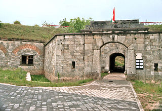
Komárom is a city in Hungary on the south bank of the Danube in Komárom-Esztergom County. Komárno, Slovakia, is on the northern bank. Komárom was formerly a separate village called Újszőny. In 1892 Komárom and Újszőny were connected with an iron bridge and in 1896 the two towns were united under the name city of Komárom. The fortress played an important role in the Hungarian Revolution of 1848 and many contemporary English sources refer to it as the Fortress of Comorn.

<span class="mw-page-title-main">Esztergom</span> City with county rights in Komárom-Esztergom, Hungary

Esztergom is a city with county rights in northern Hungary, 46 kilometres northwest of the capital Budapest. It lies in Komárom-Esztergom County, on the right bank of the river Danube, which forms the border with Slovakia there. Esztergom was the capital of Hungary from the 10th until the mid-13th century when King Béla IV of Hungary moved the royal seat to Buda.

<span class="mw-page-title-main">György Klapka</span> Hungarian soldier (1820–1892)

György (Móric) Klapka was a Hungarian general. He was one of the most important Hungarian generals of the Hungarian War of Independence of 1848–1849, politician, member of the Hungarian Parliament, and deputy War Minister.

<span class="mw-page-title-main">Csepel</span> District of Budapest in Central Hungary, Hungary

Csepel, officially known as the 21st District of Budapest is a district and a neighbourhood in Budapest, Hungary. Csepel officially became part of Budapest on 1 January 1950.

<span class="mw-page-title-main">Margaret Bridge</span> Three-way bridge in Budapest, Hungary

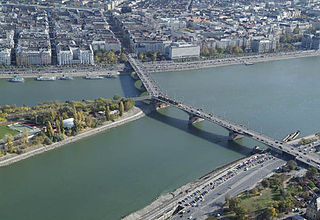
Margaret Bridge or Margit híd is a three-way bridge in Budapest, Hungary, connecting Buda and Pest across the Danube and linking Margaret Island to the banks. It is the second-northernmost and second-oldest public bridge in Budapest.

<span class="mw-page-title-main">Árpád Bridge</span> Bridge in Budapest, Hungary

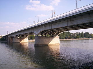
Árpád Bridge or Árpád híd is a bridge in Budapest, Hungary, connecting northern Buda (Óbuda) and Pest across the Danube.

<span class="mw-page-title-main">Rákóczi Bridge</span>

Rákóczi Bridge is a bridge in Budapest, Hungary, connecting the settlements of Buda and Pest across the Danube. The construction of the steel girder bridge was started in 1992 to the plans of Tibor Sigrai.

<span class="mw-page-title-main">Dorog</span> Town in Komárom-Esztergom, Hungary

Dorog is a small town in Komárom-Esztergom County, Hungary. It lies 38 km (24 mi) north-west from the center of Budapest.

The bridges of Budapest, Hungary, crossing the River Danube from north to south are as follows:

<span class="mw-page-title-main">Megyeri Bridge</span> Bridge in Budapest

The Megyeri Bridge, previously known as the Northern M0 Danube bridge, is a cable-stayed bridge that spans the River Danube between Buda and Pest, respectively the west and east sides of Budapest, the capital of Hungary. It is an important section of the M0 ringroad around Budapest.

Budapest is the capital of Hungary. Below is a list of public place names of Budapest that refer to famous people, cities or historic events. Generality of Budapest's public place names relate to the Hungarian national history. In Budapest there are about 8,600 named public place.

<span class="mw-page-title-main">Danube Promenade</span> Promenade in Budapest, Hungary

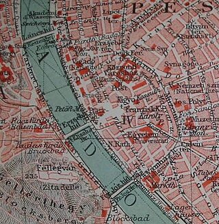
The Danube Promenade is located on the Pest side of Budapest, Hungary. The promenade itself lies on the left bank of the Danube, extending from the Széchenyi Chain Bridge to the Erzsébet Bridge.
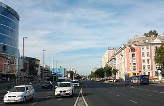
Ács is a town in Komárom-Esztergom county, northern Hungary.

<span class="mw-page-title-main">First Battle of Komárom (1849)</span> Battle of the Hungarian War of Independence

The First battle of Komárom was one of the most important battles of the Hungarian War of Independence, fought on 26 April 1849, between the Hungarian and the Austrian Imperial main armies, which some consider ended as a Hungarian victory, while others say that actually it was undecided. This battle was part of the Hungarian Spring Campaign. After the revolutionary army attacked and broke the Austrian siege of the fortress, the Imperials, having received reinforcements which made them numerically very superior to their enemies, successfully counterattacked, but after stabilising their situation, they retreated towards Győr, leaving the trenches and much of their siege artillery in Hungarian hands. By this battle the Hungarian revolutionary army relieved the fortress of Komárom from a very long imperial siege, and forced the enemy to retreat to the westernmost margin of the Kingdom of Hungary. After this battle, following a long debate among the Hungarian military and political leaders about whether to continue their advance towards Vienna, the Habsburg capital, or towards the Hungarian capital, Buda, whose fortress was still held by the Austrians, the second option was chosen.

Paul from the kindred Szécs, also known as Paul of Komárom, was a Hungarian nobleman and landowner who was lord of Komárom from the 1280s. He came to prominence during the last regnal years of Andrew III of Hungary.

<i>Clark Ádám</i> (crane vessel)

Clark Ádám is a crane vessel, specifically a floating sheerleg, built in 1980 in Budapest, Hungary, by the Hungarian Shipyards and Crane Factory Angyalföld Division. It originally had a lifting capacity of 120 metric tons, gradually raised to 200 tons by 2006, making it one of the largest in lifting capacity on Central European rivers. It is mainly used for building bridges, but is also commissioned to assist salvage operations, as well as to launch hydrofoils. It has rescued several ships; in 2019 it raised the sunken Hableány from the Danube at Budapest. The vessel is named after Scottish engineer Adam Clark (1811–1866).

<span class="mw-page-title-main">Fourth Battle of Komárom (1849)</span>

The Fourth Battle of Komárom was fought in 30 July and 3 August 1849 between the Hungarian garrison of the fortress of Komárom led by General György Klapka and the besieging Austrian army led by Lieutenant field marshal Anton Freiherr Csorich von Monte Creto. Thanks to the capturing, by a Hungarian detachment of Hussars, of a statement containing the number of the besieging Austrian II. corps, Klapka understood, that he actually has numerical superiority over the besiegers. So in two sorties made on 30 July and 3 August he managed to crush their siege on the northern, then also on the southern section of the fortress, chasing them towards West, and causing them heavy losses. Thanks to this victory Klapka liberated the region between Komárom and Győr, planning to attack Austria, when he learned about the surrender of the Hungarian main troops from 13 August, and as result of this, he retreated with his troops in Komárom.