
Uruguay, officially the Oriental Republic of the Uruguay, is a country in South America. It shares borders with Argentina to its west and southwest and Brazil to its north and northeast; while bordering the Río de la Plata to the south and the Atlantic Ocean to the southeast. Uruguay covers an area of approximately 176,000 square kilometers (68,000 sq mi) and has a population of an estimated 3.51 million, of whom 2 million live in the metropolitan area of its capital and largest city, Montevideo.

Uruguay is a country in the southeastern region of South America, bordering the Atlantic Ocean, between Argentina and Brazil. It is located in the Southern Hemisphere on the Atlantic seaboard of South America between 53 and 58 west longitude and 30 and 35 south latitude. It is bordered to the west by Argentina, on the north and northeast by Brazil, and on the southeast by the Atlantic Ocean, which makes up Uruguay's coast.

South is one of the cardinal directions or compass points. South is the opposite of north and is perpendicular to east and west.
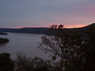
The Uruguay River is a major river in South America. It flows from north to south and forms parts of the boundaries of Brazil, Argentina, and Uruguay, separating some of the Argentine provinces of La Mesopotamia from the other two countries. It passes between the states of Santa Catarina and Rio Grande do Sul in Brazil; forms the eastern border of the provinces of Misiones, Corrientes, and Entre Ríos in Argentina; and makes up the western borders of the departments of Artigas, Salto, Paysandú, Río Negro, Soriano, and Colonia in Uruguay.
Uruguaiana is a municipality in the Brazilian state of Rio Grande do Sul. It is located on the eastern shore of the Uruguay River bordering Argentina. Opposite to Uruguaiana, and joined to it by a road/railway bridge, lies the Argentine city of Paso de los Libres, Corrientes. North of Uruguaiana lies the Brazilian municipality of Itaqui, connected by a bridge constructed by the English in 1888 over the Ibicuí River. The municipality also borders the municipalities of Alegrete, Barra do Quaraí and Quaraí, and, also, Uruguay, making it one of the few international triple-border municipalities of Brazil.

Fray Bentos is the capital city of the Río Negro Department, in south-western Uruguay. Its port on the Uruguay River is one of the nation's most important harbours. The city hosts the first campus of the Technological University, beside the historically relevant industrial complex Anglo, a World Heritage site.
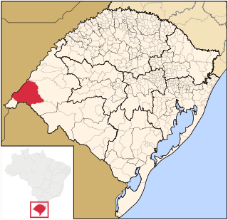
Río Negro Department is a department of the northwestern region of Uruguay. It has an area of 9,282 km2 (3,584 sq mi) and a population of 54,765. Its capital is Fray Bentos. It borders Paysandú Department to the north, Tacuarembó Department to the east, Durazno Department to the southeast, Soriano Department to the south and has the Río Uruguay flowing at its west, separating it from Argentina.

Paysandú is the capital of Paysandú Department in western Uruguay.

The pulp mill dispute was a dispute between Argentina and Uruguay concerning the construction of pulp mills on the Uruguay River. The presidents at the time were Néstor Kirchner (Argentina) and Tabaré Vázquez (Uruguay). As a diplomatic, economic, and public relations conflict between both parties, the dispute also affected tourism and transportation as well as the otherwise amicable relations between the two countries. The feud was unprecedented between the two countries, which have shared historical and cultural ties.
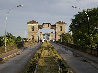
The Libertador General San Martín Bridge is a cantilever road bridge that crosses the Uruguay River and joins Argentina and Uruguay. It runs between Puerto Unzué, near Gualeguaychú, Entre Ríos Province, Argentina, and Fray Bentos, Río Negro Department, Uruguay, with a total length of 5,366 meters (3.7 mi).

The General Artigas Bridge is an international road bridge that crosses the Uruguay River and joins Argentina and Uruguay. It runs between Colón, Entre Ríos Province, Argentina, and Paysandú, Paysandú Department, Uruguay. It is a cantilever bridge with a total length of 2,350 metres (7,709 ft). The main span of the bridge measures 140 metres (460 ft) in length.

The Salto Grande Dam is a large hydroelectric dam on the Uruguay River, located between Concordia, Argentina, and Salto, Uruguay; thus shared between the two countries.

Carmelo is a city located in the department of Colonia of western Uruguay, noted for its wineries.

Santana do Livramento is a city in the state of Rio Grande do Sul, Brazil. It is located along the border with the city of Rivera, Uruguay, forming together an international city of almost 170,000 inhabitants. Santana do Livramento was founded on July 30, 1823, and in 1857 was emancipated from Alegrete as a city. In 2009, the city was officially declared by the Brazilian government as the symbolic city of Brazilian integration with the Mercosur member states.
Jaguarão is a municipality in the southern Brazilian state of Rio Grande do Sul located on the shores of the Jaguarão River, bordering Uruguay.

Rocha is the capital city of the Rocha Department in Uruguay.

Route 10 is a national route of Uruguay. In 1983, it was assigned the name Juan Díaz de Solís, honouring the Spanish navigator.

Laguna José Ignacio is a body of water located between Maldonado Department and Rocha Department, Uruguay.

The Currents Bridge, is a tied-arch bridge that crosses the Lérez River in the city of Pontevedra, Spain. It was inaugurated in 2012 and connects Uruguay Avenue and Domingo Fontán Street.


