| Crossing | Distance from mouth (in km) | Carries | Location | Built | Coordinates | Photo |
|---|
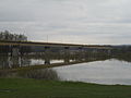
Andreas Maurer bridge  | 1886.2 | Bernstein Straße | Hainburg an der Donau, Engelhartstetten | Dec 1972 | |  |
|---|
| Barbara bridge | 1914.4 | Gas pipe | Schwechat, Vienna | 1957 | |  |
|---|
| Mannswörth pipeline bridge | 1917.7 | Gas pipe [f] [g] | Schwechat, Vienna | 1959 | |  |
|---|
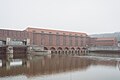
| Weir 2 [h] | 1918.3 | Footpath | Vienna | 1988 | |  |
|---|
| Waluliso Bridge [i] | | Footpath [j] | Vienna | 1998 | |  |
|---|
| Freudenauer Hafenbrücke | 1921.1 | Covered pedestrian/bicycle path with viewing platform | Vienna | 1992 | |  |
|---|
| Steinsporn Bridge | | Footpath | Vienna | 1974 | |  |
|---|
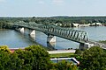
| Stadlau Eastern Railway Bridge | 1925 | Laaer Ostbahn | Vienna [12] | 1931 | |  |
|---|
| Prater Bridge | 1925.8 | Vienna Southeast Bypass motorway A23 | Vienna | 1967 [k] | |  |
|---|
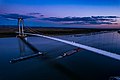
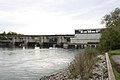
| Danube city bridge | 1926 | Line U2 | Vienna | Mar 1997 | | 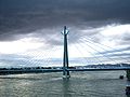 |
|---|
| Weir 1 [l] | 1926.2 | Footpath | Vienna | 1978 | | 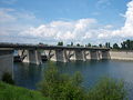 |
|---|
| Kaisermühlen Bridge | | Footpath | Vienna | 1993 | |  |
|---|
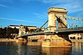
| Reichsbrücke | 1928.9 | Angerner Straße, U1 | Vienna | 8 Nov 1980 [13] | |  |
|---|
| Ponte Cagrana [m] | | pedestrian/bicycle access [n] | Vienna | 2000 | |  |
|---|
| Brigittenauer Bridge | 1930.4 | Klosterneuburger Straße | Vienna | 25 Oct 1982 | |  |
|---|
| Georg Danzer Bridge | 1931.2 | Line U6 | Vienna | 1991 | |  |
|---|
| Northern Railway Bridge | 1931.2 | North railway line | Vienna | 1870 | |  |
|---|
| Floridsdorfer Brücke | 1931.7 | Floridsdorfer Straße | Vienna [14] | 1924 [o] | | 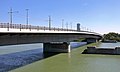 |
|---|
| Steinitzsteg Footbridge | 1932.5 | Footpath | Vienna | 1995 | | 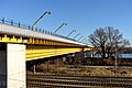 |
|---|
| North Bridge | 1932.6 | North Bridge Feeder | Vienna | 19 Dec 1964 | |  |
|---|
| Jedleseer Bridge | | Footpath | Vienna | 1983 | | 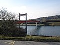 |
|---|
| Langenzersdorf intake structure | 1938.1 | pedestrian/bicycle crossing between Langenzersdorf and the Danube Island | Klosterneuburg, Langenzersdorf | 1975 | | 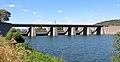 |
|---|
| Greifenstein power station | 1949.2 | Footpath | Sankt Andrä-Wördern, Spillern | 1981 | | 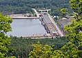 |
|---|
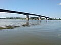
| Donaubrücke Tulln | 1963.2 | Railway line, Tullner Straße | Tulln an der Donau | 1875 | |  |
|---|
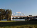
| Rose Bridge | 1965.4 | Tullner Straße | Tulln an der Donau, Langenrohr | 1992 | |  |
|---|
| Altenwörth power station | 1980.4 | Footpath | Altenwörth | 1973 | |  |
|---|
| Traismauer Danube motorway bridge | 1991.4 | S33 expressway | Krems, Gedersdorf, Grafenwörth | 31 Oct 2010 | [15] |  |
|---|
| Krems Danube bridge | 1999.8 | Kremser Straße | Furth bei Göttweig [15] , Krems [15] | 1971 | | 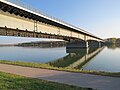 |
|---|
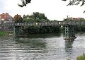
| Krems railway bridge | 2001.5 | Bahnstrecke Krems an der Donau - Herzogenburg | Mautern an der Donau, Krems | 1889 [p] | | 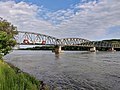 |
|---|
| Mauterner Donaubrücke | 2003.6 | Aggsteiner Straße | Krems [16] , Mautern an der Donau | 18 May 1895 | |  |
|---|
| Melk Danube Bridge | 2034.5 | Melker Straße | Emmersdorf an der Donau [15] , Melk [15] | 1972 | | 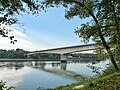 |
|---|
| Melk power station dam | 2038 | Footpath | Melk [15] , Emmersdorf an der Donau [15] , Zelking-Matzleinsdorf [15] , Leiben [15] | 1979 | |  |
|---|
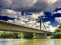
| Pöchlarn Danube bridge | 2043.6 | Pöchlarner Straße | Pöchlarn | 2002 | |  |
|---|
| Persenbeug Dam | 2060.4 | Erlauftal Straße | Ybbs an der Donau, Hofamt Priel | 1959 | | 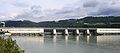 |
|---|
| Leopold Helbich Bridge | 2080.8 | Greiner Straße | Grein | 1965 | |  |
|---|
| Wallsee-Mitterkirchen power station | 2094.5 | road (L1427) | Mitterkirchen im Machland, Wallsee-Sindelburg | 1965 | |  |
|---|
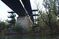
| Mauthausen railway bridge | 2111.1 | Donauuferbahn, Summerauer Bahn | Mauthausen, Sankt Pantaleon-Erla | 1872 | |  |
|---|
| Mauthausen Danube bridge | 2111.1 | Mauthausener Straße | Mauthausen, Sankt Pantaleon-Erla | 1962 | |  |
|---|
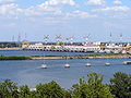
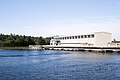
| Abwinden-Asten power station | 2119.6 | Footpath, bike path | Luftenberg an der Donau | 1973 | |  |
|---|
| Steyregg Railway Bridge | 2127.6 | Summerauer Bahn | Steyregg, Linz | 1873 | | 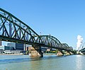 |
|---|
| Steyregger Bridge | 2127.7 | Donau Straße | Steyregg, Linz | 12 Sep 1979 | |  |
|---|
| VÖEST Bridge | 2133.5 | Mühlkreis Autobahn | Linz | 1968 | |  |
|---|
| Eisenbahnbrücke, Linz | 2133.9 | railway, road (129), pedestrians - to be closed in 2012 [17] | Linz | 1900 | |  |
|---|
| Nibelungen Bridge | 2135.1 | Eferdinger Straße | Linz | 1938 | |  |
|---|
| Ottensheim-Wilhering power station | 2146.7 | Footpath, bike path | Ottensheim | 1970 | |  |
|---|
| Aschach Danube Bridge | 2160 | Aschacher Straße | Aschach an der Donau, Feldkirchen an der Donau | 1962 [18] | |  |
|---|
| Niederranna Danube bridge | 2194 | Niederranna-Wesenufer road (L587) | Hofkirchen im Mühlkreis, Waldkirchen am Wesen | 1980 | |  |
|---|