Ottensheim

Last updated
Ottensheim
Ottensheim - Ortsansicht (b).JPG
Wappen at ottensheim.png
Austria adm location map.svg
Red pog.svg
Ottensheim
Location within Austria
Coordinates: 48°20′00″N14°10′37″E / 48.33333°N 14.17694°E / 48.33333; 14.17694
Country Austria
State Upper Austria
District Urfahr-Umgebung
Government
  BurgermeisterFranz Füreder (Austrian People's Party (ÖVP))
Area
[1]
  Total11.81 km2 (4.56 sq mi)
Elevation
270 m (890 ft)
Population
 (2018-01-01) [2]
  Total4,721
  Density400/km2 (1,000/sq mi)
Time zone UTC+1 (CET)
  Summer (DST) UTC+2 (CEST)
Postal code
4100
Area code 07234
Vehicle registration UU
Website www.ottensheim.
ooe.gv.at

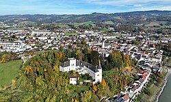
Ottensheim is a municipality in the district of Urfahr-Umgebung in the Austrian state of Upper Austria. At its rowing venue, Regattastrecke Ottensheim, it has hosted numerous international rowing competitions, including various World Championships, World U23 Championships, World Junior Championships, and World Cups.

Contents

History

First settlements in this area date from about 4000 BC. The first mention of the settlement in a document dates from 1148 AD. In 1228 AD, Ottensheim received the market right – as third town in Upper Austria, after Linz (1210) and Enns (1212). In 1527, the Habsburg-Monarch Ferdinand I endowed the town and the castle to his chancellor Niklas Rabenhaupt von Suche, who expanded the castle. The coat of arms of Ottensheim dates from this time.

Ottensheim has existed as a municipality since 1848. At this time and until 1893 the now self-contended municipality Puchenau also belonged to Ottensheim. In 1871 the first ferry over the Danube was installed. It was destroyed by an ice jam eight years later, and rebuilt in 1882. In 1964 the now still working ferry boat was built. Every year since the 1990s an alternative music festival for about 2,000 people takes place on the Rodl park near the Danube river, the Open Air Ottensheim, where local and international rock, hip-hop and experimental music acts take place.

Most residents work in the closest city, Linz. Ottensheim has many parks and sporting facilities as well as a secondary school, music school, cinema (est. 1919, one of the oldest in Upper Austria), police station and post office which also serves the neighbouring villages. Ottensheim also has Austria's 7th largest hydroelectric power plant, on the Danube.

Politics

The governor of Ottensheim is Franz Füreder from the Austrian People's Party (ÖVP), who won the direct vote. The municipal council is formed by 10 mandates of the Austrian People's Party, 7 mandates of the Social Democratic Party of Austria (SPÖ), 7 of "Pro O" and one mandate of the right Freedom Party of Austria (FPÖ). The left party The Greens – The Green Alternative does not exist in Ottensheim, but has, with 20–25%, the highest rate of voters in Upper Austria in case of nationwide votes.

Related Research Articles

<span class="mw-page-title-main">Mauthausen, Upper Austria</span> Place in Upper Austria, Austria

Mauthausen is a small market town in the Austrian state of Upper Austria. It is located at about 20 kilometres east of the city of Linz. The town lies on the banks of the Danube river, opposite the town of Enns, where the major Danube tributary of Enns joins it. During World War II, the town was the site of the Mauthausen concentration camp.

<span class="mw-page-title-main">Melk</span> Place in Lower Austria, Austria

Melk is a city in the Austrian state of Lower Austria, next to the Wachau valley along the Danube. Melk has a population of 5,257. It is best known as the site of a massive baroque Benedictine monastery named Melk Abbey.

<span class="mw-page-title-main">Oberpullendorf</span> Place in Burgenland, Austria

Oberpullendorf is a town in Burgenland, Austria. It is the administrative center of the district of Oberpullendorf.

<span class="mw-page-title-main">Werfen</span> Municipality in Salzburg, Austria

Werfen is a market town in the district of St. Johann im Pongau, in the Austrian state of Salzburg. It is mainly known for medieval Hohenwerfen Castle and the Eisriesenwelt ice cave, the largest in the world.

<span class="mw-page-title-main">Attersee am Attersee</span> Place in Upper Austria, Austria

Attersee am Attersee is a village on the western shore of Attersee lake in the Austrian state of Upper Austria.

<span class="mw-page-title-main">Enns (town)</span> Place in Upper Austria, Austria

Enns is a town in the Austrian state of Upper Austria on the river Enns, which forms the border with the state of Lower Austria.

<span class="mw-page-title-main">Hainburg an der Donau</span> Town in Lower Austria, Austria

Hainburg an der Donau is a town located in the Bruck an der Leitha district in the state of Lower Austria of eastern Austria. In 2021 it had a population of about 7,000.

<span class="mw-page-title-main">Pasching</span> Place in Upper Austria, Austria

Pasching is a municipality in the Austrian state of Upper Austria. It is situated a few miles southwest of Linz and borders Leonding, Hörsching, Wilhering and Traun.

<span class="mw-page-title-main">Freistadt</span> Place in Upper Austria, Austria

Freistadt is a small Austrian town in the state of Upper Austria in the region Mühlviertel. With a population of approximately 7,500 residents, it is a trade centre for local villages. Freistadt is the economic centre of a district of the same name District Freistadt. The nearest sizeable cities are Linz, the capital of Upper Austria, about 40 km in the south, and České Budějovice, the capital of Southern Bohemia, about 60 km in the north.

<span class="mw-page-title-main">Schärding</span> Place in Upper Austria, Austria

Schärding is a town in the northern Austrian state of Upper Austria, the capital of the district of the same name, and a major port on the Inn River. Historically, it was owned by the Wittelsbach family, which is reflected in the town's architecture.

<span class="mw-page-title-main">Kötschach-Mauthen</span> Place in Carinthia, Austria

Kötschach-Mauthen is a market town in the district of Hermagor in Carinthia in Austria.

<span class="mw-page-title-main">Lesachtal</span> Place in Carinthia, Austria

Lesachtal is a municipality in Hermagor District, in the Austrian state of Carinthia. It comprises the western part of the eponymous valley formed by the upper Gail River, and stretches from the Carinthian border with East Tyrol down to Kötschach-Mauthen in the east.

<span class="mw-page-title-main">Bad Sankt Leonhard im Lavanttal</span> Place in Carinthia, Austria

Bad Sankt Leonhard im Lavanttal is a spa town in the district of Wolfsberg in the Austrian state of Carinthia.

<span class="mw-page-title-main">Eferding</span> Place in Upper Austria, Austria

Eferding is the capital of the Eferding district in the Austrian state of Upper Austria.

<span class="mw-page-title-main">Aschach an der Donau</span> Place in Upper Austria, Austria

Aschach an der Donau is a municipality in the district Eferding in the Austrian state of Upper Austria.

<span class="mw-page-title-main">Vorchdorf</span> Place in Upper Austria, Austria

Vorchdorf is a market town in the district of Gmunden in Upper Austria, Austria, as well as the name of the municipal area ("Gemeinde") that the town and others occupy. As of the 2005 census, the town of Vorchdorf had a population of 7,287 inhabitants.

<span class="mw-page-title-main">Windischgarsten</span> Place in Upper Austria, Austria

Windischgarsten is a municipality in the district of Kirchdorf an der Krems in the Austrian state of Upper Austria. Since 1964, the town has been classified as a Luftkurort, a mountain spa town.

Dimbach is a municipality in the district Perg in Upper Austria, Austria. It had a population of 1015 according to the 2015 census.

Pühret is a municipality in the district of Vöcklabruck in the Austrian state of Upper Austria, with an estimated population of 613 inhabitants at the start of 2018.

<span class="mw-page-title-main">Donausteig (Danube Trail)</span> Hiking trail

The Donausteig is a hiking trail that passes through parts of Bavaria and Austria. Since the summer of 2010, the trail follows both banks of the Danube, from Passau via Linz up to St. Nikola and Grein.

References

  1. "Dauersiedlungsraum der Gemeinden Politischen Bezirke und Bundesländer - Gebietsstand 1.1.2018". Statistics Austria. Retrieved 10 March 2019.
  2. "Einwohnerzahl 1.1.2018 nach Gemeinden mit Status, Gebietsstand 1.1.2018". Statistics Austria. Retrieved 9 March 2019.