Eidenberg

Last updated

Eidenberg
A4201-Eidenberg-Neues-Schloss 2013 001.jpg
New castle
Wappen at eidenberg.png
Coat of arms
Austria adm location map.svg
Red pog.svg
Eidenberg
Location within Austria
Coordinates: 48°23′42″N14°13′51″E / 48.39500°N 14.23083°E / 48.39500; 14.23083 Coordinates: 48°23′42″N14°13′51″E / 48.39500°N 14.23083°E / 48.39500; 14.23083
Country Austria
State Upper Austria
District Urfahr-Umgebung
Government
   Mayor Adolf Hinterhölzl (ÖVP)
Area
[1]
  Total29.28 km2 (11.31 sq mi)
Elevation
685 m (2,247 ft)
Population
 (2018-01-01) [2]
  Total2,105
  Density72/km2 (190/sq mi)
Time zone UTC+1 (CET)
  Summer (DST) UTC+2 (CEST)
Postal code
4201
Area code 07239
Vehicle registration UU
Website www.eidenberg.at

Eidenberg is a municipality in the district of Urfahr-Umgebung in the Austrian state of Upper Austria, with 2105 inhabitants (as of 1 January 2018). The community is located in the judicial district Urfahr.

Austria Federal republic in Central Europe

Austria, officially the Republic of Austria, is a country in Central Europe comprising nine federated states. Its capital, largest city and one of nine states is Vienna. Austria has an area of 83,879 km2 (32,386 sq mi), a population of nearly nine million people and a nominal GDP of $477 billion. It is bordered by the Czech Republic and Germany to the north, Hungary and Slovakia to the east, Slovenia and Italy to the south, and Switzerland and Liechtenstein to the west. The terrain is landlocked and highly mountainous, lying within the Alps; only 32% of the country is below 500 m (1,640 ft), and its highest point is 3,798 m (12,461 ft). The majority of the population speaks local Bavarian dialects as their native language, and German in its standard form is the country's official language. Other regional languages are Hungarian, Burgenland Croatian, and Slovene.

Upper Austria State of Austria

Upper Austria is one of the nine states or Bundesländer of Austria. Its capital is Linz. Upper Austria borders on Germany and the Czech Republic, as well as on the other Austrian states of Lower Austria, Styria, and Salzburg. With an area of 11,982 km2 (4,626 sq mi) and 1.437 million inhabitants, Upper Austria is the fourth-largest Austrian state by land area and the third-largest by population.

A judicial district or legal district denotes the territorial area for which a legal court (law) has jurisdiction.

Population

Historical population
YearPop.±%
19911,646    
20011,812+10.1%
20081,988+9.7%

Related Research Articles

Alberndorf in der Riedmark Place in Upper Austria, Austria

Alberndorf in der Riedmark is a municipality in the district of Urfahr-Umgebung in the Austrian state of Upper Austria.

Altenberg bei Linz Place in Upper Austria, Austria

Altenberg bei Linz is a municipality in the district of Urfahr-Umgebung in the Austrian state of Upper Austria.

Feldkirchen an der Donau Place in Upper Austria, Austria

Feldkirchen an der Donau is a municipality in the district of Urfahr-Umgebung in the Austrian state of Upper Austria.

Goldwörth Place in Upper Austria, Austria

Goldwörth is a municipality in the district of Urfahr-Umgebung in the Austrian state of Upper Austria.

Haibach im Mühlkreis Place in Upper Austria, Austria

Haibach im Mühlkreis is a municipality in the district of Urfahr-Umgebung in the Austrian state of Upper Austria.

Hellmonsödt Place in Upper Austria, Austria

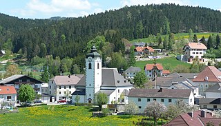
Hellmonsödt is a municipality in the district of Urfahr-Umgebung in the Austrian state of Upper Austria.

Herzogsdorf Place in Upper Austria, Austria

Herzogsdorf is a municipality in the district of Urfahr-Umgebung in the Austrian state of Upper Austria.

Kirchschlag bei Linz Place in Upper Austria, Austria

Kirchschlag bei Linz is a municipality in the district of Urfahr-Umgebung in the Austrian state of Upper Austria.

Lichtenberg, Austria Place in Upper Austria, Austria

Lichtenberg is a municipality in the district of Urfahr-Umgebung in the Austrian state of Upper Austria.

Oberneukirchen, Austria Place in Upper Austria, Austria

Oberneukirchen is a municipality in the district of Urfahr-Umgebung in the Austrian state of Upper Austria.

Ottenschlag im Mühlkreis Place in Upper Austria, Austria

Ottenschlag im Mühlkreis is a municipality in the district of Urfahr-Umgebung in the Austrian state of Upper Austria.

Puchenau Place in Upper Austria, Austria

Puchenau is a municipality in the district of Urfahr-Umgebung in the Austrian state of Upper Austria. Until 1893 it was part of the neighbouring town of Ottensheim.

Reichenau im Mühlkreis Place in Upper Austria, Austria

Reichenau im Mühlkreis is a municipality in the district of Urfahr-Umgebung in the Austrian state of Upper Austria.

Reichenthal Place in Upper Austria, Austria

Reichenthal is a municipality in the district of Urfahr-Umgebung in the Austrian state of Upper Austria.

Schenkenfelden Place in Upper Austria, Austria

Schenkenfelden is a municipality in the district of Urfahr-Umgebung in the Austrian state of Upper Austria.

Sonnberg im Mühlkreis Place in Upper Austria, Austria

Sonnberg im Mühlkreis is a municipality in the district of Urfahr-Umgebung in the Austrian state of Upper Austria.

Steyregg Place in Upper Austria, Austria

Steyregg is a municipality in the district of Urfahr-Umgebung in the Austrian state of Upper Austria.

Vorderweißenbach Place in Upper Austria, Austria

Vorderweißenbach is a municipality in the district of Urfahr-Umgebung in the Austrian state of Upper Austria.

Walding Place in Upper Austria, Austria

For people with the surname, see Walding (surname).

Zwettl an der Rodl Place in Upper Austria, Austria

Zwettl an der Rodl is a municipality in the district of Urfahr-Umgebung in the Austrian state of Upper Austria.

References

  1. "Dauersiedlungsraum der Gemeinden Politischen Bezirke und Bundesländer - Gebietsstand 1.1.2018". Statistics Austria. Retrieved 10 March 2019.
  2. "Einwohnerzahl 1.1.2018 nach Gemeinden mit Status, Gebietsstand 1.1.2018". Statistics Austria. Retrieved 9 March 2019.