Neu-Ulm

Last updated
Neu-Ulm
Neu-ulm-petrusplatz.jpg
Saint Peter's Square
DEU Neu-Ulm COA.svg
Location of Neu-Ulm within Neu-Ulm district
Neu-Ulm in NU.svgAuwaldOberroggenburger WaldStoffenrieder ForstUnterroggenburger WaldAltenstadtBuchHolzheimRoggenburgVöhringen
Germany adm location map.svg
Red pog.svg
Neu-Ulm
Bavaria location map.svg
Red pog.svg
Neu-Ulm
Coordinates: 48°23′N10°00′E / 48.383°N 10.000°E / 48.383; 10.000
Country Germany
State Bavaria
Admin. region Schwaben
District Neu-Ulm
Subdivisions12 Stadtteile
Government
   Lord mayor (202026) Katrin Albsteiger [1] (CSU)
Area
  Total80.50 km2 (31.08 sq mi)
Highest elevation
527 m (1,729 ft)
Lowest elevation
470 m (1,540 ft)
Population
 (2022-12-31) [2]
  Total61,043
  Density760/km2 (2,000/sq mi)
Time zone UTC+01:00 (CET)
  Summer (DST) UTC+02:00 (CEST)
Postal codes
89201–89233
Dialling codes 0731, 07307, 07308
Vehicle registration NU
Website nu.neu-ulm.de

Neu-Ulm (Swabian: Nej-Ulm) is the seat of the Neu-Ulm district and a town in Swabia, Bavaria. Neighbouring towns include Ulm, Senden, Pfaffenhofen an der Roth, Holzheim, Nersingen and Elchingen. The population is 58,978 (31 December 2019).

Contents

History

The modern history of Neu-Ulm began with the change of the sovereignty over the city of Ulm in 1810 from the Kingdom of Bavaria to the Kingdom of Württemberg. The Danube became the boundary between Bavaria and Württemberg. Land on the right bank of the Danube thus remained under Bavarian sovereignty. This was the beginning of Neu-Ulm's status as an independent town.

At this time Neu-Ulm was very small with little more than a few houses, taverns, pieces of land, and the village of Offenhausen. It was still known as Ulm am rechten Donauufer (Ulm on the right-hand side of the Danube). The name "Neu-Ulm" was first mentioned in records in 1814.

The town's real growth began a few decades later in 1841, when the Frankfurter Bundesversammlung announced the building of the Federal Fort of Ulm, the Bundesfestung. Upon the wishes of King Ludwig I, Neu-Ulm was included within the fort and the building work in Neu-Ulm was overseen by Major Theodor von Hildebrandt. [3] [ better source needed ] After Neu-Ulm was connected to the railway line to Augsburg in 1853, soldiers arrived and a garrison was created there.

The city began to blossom under Mayor Josef Kollmann at the end of the 19th century. A tram line connecting Ulm and Neu-Ulm was built in 1897 and in 1900 the water tower (still a landmark today) was built, guaranteeing Neu-Ulm's water supply. In 1906, Neu-Ulm expanded beyond the city walls for the first time. The first factories were built, and it continued to expand.

After World War I, the garrison was closed. The population and wealth of the town grew, and it became a rich town. However, World War II left its mark; nearly eighty percent of the town was destroyed by Allied bombing, and all bridges across the Danube to Ulm were destroyed.

Rebuilding began, and from the end of World War II up to the 1990s, the US Army were stationed in Neu-Ulm. In 1968 the 1st Battalion, 81st Field Artillery Regiment moved from Wackernheim to Wiley Barracks. It was initially equipped with eight Pershing 1 nuclear missiles and in 1969 replaced these with 36 Pershing 1a missiles, replacing these with Pershing II missiles in 1984. The battalion was inactivated in 1986 and reformed as the 1st Battalion, 9th Field Artillery Regiment. With the ratification of the Intermediate-Range Nuclear Forces Treaty on 27 May 1988 the missiles were destroyed and the battalion was inactivated on 30 June 1991.

The departure of the US Army had a large impact on the town's economy and also left a large number of vacant army buildings.

Coat of arms

In 1857, the town was given a coat of arms, although it was not legally a city at the time. It was first granted city status by King Ludwig II in 1869. The coat of arms consists of three horizontal bands of black, white and blue, with a tower in front. The tower symbolises the fort built around Neu-Ulm, the colours black and white indicate the relationship with Ulm, and the colours white and blue show the association with Bavaria.

Districts

Neu-Ulm is arranged into 14 districts, 9 of them added between 1972 and 1977. The districts are: Burlafingen, Finningen, Gerlenhofen, Hausen, Holzschwang (including Tiefenbach), Jedelhausen, Ludwigsfeld, Neu-Ulm, Offenhausen, Pfuhl, Reutti, Schwaighofen, Steinheim and Wiley.

Politics

Neu-Ulm is currently controlled by the Christian Social Union (CSU). The mayor is Katrin Albsteiger, elected in March 2020. [1] Her predecessor was Gerold Noerenberg, who was in office between 2004 and 2020. He had succeeded Beate Merk, who had been appointed as Bavarian law minister by Edmund Stoiber on 14 October 2003.

Neu-Ulm is part of the Neu-Ulm (electoral district) for elections to the Bundestag.

The town council is arranged into four parliamentary groups with eight different parties and citizens' initiatives (the number of seats are shown in brackets):

Education and science

In 1994, the Neu-Ulm Fachhochschule (University of Applied Sciences) was founded. The School of Economics was first opened as a branch office of the Fachhochschule Kempten im Allgäu , but has been independent since 1998. The Fachhochschule Neu-Ulm was initially located in the buildings of the former US base's Wiley Barracks, before expanding into two floors of the newly built Edison Center and then transferring to a new, larger building on the site of the former US base in summer 2008.

Twin towns – sister cities

Neu-Ulm is twinned with: [4]

Notable people

Hermann Kohl 1930 second from the left Bundesarchiv Bild 102-09801, Ozeanflieger Hauptmann Kohl.jpg
Hermann Köhl 1930 second from the left

Associated with the town

Related Research Articles

<span class="mw-page-title-main">Ulm</span> City in Baden-Württemberg, Germany

Ulm is a city in the German state of Baden-Württemberg, situated on the river Danube on the border with Bavaria. The city, which has an estimated population of more than 126,000 (2018), forms an urban district of its own and is the administrative seat of the Alb-Donau district.

Günzburg is a Landkreis (district) in Swabia, Bavaria, Germany. Its capital is the town Günzburg. It is bounded by the districts of Dillingen, Augsburg, Unterallgäu and Neu-Ulm, and by the state of Baden-Württemberg.

Neu-Ulm is a Landkreis (district) in Swabia, Bavaria, Germany. It is bounded by the districts of Günzburg and Unterallgäu and the state of Baden-Württemberg.

<span class="mw-page-title-main">Memmingen</span> Town in Bavaria, Germany

Memmingen is a town in Swabia, Bavaria, Germany. It is the economic, educational and administrative centre of the Danube-Iller region. To the west the town is flanked by the Iller, the river that marks the Baden-Württemberg border. To the north, east and south the town is surrounded by the district of Unterallgäu.

<span class="mw-page-title-main">Günzburg</span> Town in Bavaria, Germany

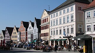
Günzburg is a town in Bavaria, Germany. It is a Große Kreisstadt and the capital of the Swabian district Günzburg. This district was constituted in 1972 by combining the city of Günzburg – which had not previously been assigned to a Kreis (district) – with the district of Günzburg and the district of Krumbach.

<span class="mw-page-title-main">Elchingen</span> Settlement in Germany

Elchingen is a municipality about 7 km east of Ulm–Neu-Ulm in the district of Neu-Ulm in Bavaria, Germany.

<span class="mw-page-title-main">Weißenhorn</span> Town in Bavaria, Germany

Weißenhorn is a town in the district of Neu-Ulm in Bavaria. Weißenhorn is located about 22 km southeast of Ulm.

<span class="mw-page-title-main">Vöhringen, Bavaria</span> Town in Bavaria, Germany

Vöhringen is a town in the district of Neu-Ulm in Bavaria, Germany. It is located on the Iller, approximately 18 km south of Ulm and 40 km north of Memmingen. It is in the Donau-Iller Region in Central Swabia.

<span class="mw-page-title-main">Senden</span> Town in Bavaria, Germany

The town of Senden is the second-largest town of the district of Neu-Ulm in Bavaria and is located at the border to Baden-Württemberg. The town belongs to the Donau-Iller-Nahverkehrsverbund. Senden's neighbours are Neu-Ulm in the north, Weißenhorn in the east, Vöhringen in the south and Illerkirchberg in the west.

<span class="mw-page-title-main">Lauingen</span> Town in Bavaria, Germany

Lauingen is a town in the district of Dillingen in Bavaria, Germany. It is located on the left bank of the Danube, 5 km west of Dillingen, and 37 km northeast of Ulm.

<span class="mw-page-title-main">Leipheim</span> Town in Bavaria, Germany

Leipheim is a town in the district of Günzburg, in Bavaria, Germany. It is situated on the Danube, 5 kilometres west of Günzburg, and 17 kilometres northeast of Ulm. The village Riedheim and the hamlet Weissingen are districts of Leipheim. Since 1993, Leipheim has been twinned with the Hungarian town Fonyód.

<span class="mw-page-title-main">Offingen</span> Municipality in Bavaria, Germany

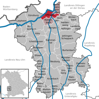
Offingen is a municipality in the Swabian administrative district Günzburg in Bavaria in Germany.

<span class="mw-page-title-main">Ulm Hauptbahnhof</span> Railway station in Ulm, Germany

Ulm Hauptbahnhof is the main station in the city of Ulm, which lies on the Danube, on the border of the German states of Baden-Württemberg and Bavaria in the Danube-Iller region.

<span class="mw-page-title-main">56th Artillery Command</span> Force Field Artillery Headquarters for U.S. Army Europe and Africa

The 56th Artillery Command is a two-star command of the United States Army that serves as the Force Field Artillery Headquarters for U.S. Army Europe and Africa, with a mission to synchronize, integrate, and control fires and effects in support of the theater land component. The unit was originally formed on September 14, 1942, as the 56th Coast Artillery Brigade and has been reorganized and redesignated several times until its inactivation on June 30, 1991, following the reunification of Germany and the end of the Cold War.

<span class="mw-page-title-main">Fortress of Ulm</span>

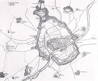
The fortress of Ulm was one of five federal fortresses of the German Confederation around the cities of Ulm and Neu-Ulm. With its 9 km polygonal main circumvallation Ulm had the biggest fortress in Germany in the 19th century and it is still one of the biggest in Europe.

<span class="mw-page-title-main">59th Ordnance Brigade</span> Brigade of the United States Army

The 59th Ordnance Brigade is a military unit of the United States Army. The unit is currently stood up as the U.S. Army Ordnance School's training brigade. In its previous iteration, the brigade had more than 6,500 soldiers. It was responsible for storage, delivering, maintaining, Nuclear and Chemical Control Orders, and supervising the weapons of mass destruction for U.S. Forces and Forces of the Allied NATO-Countries, except France.

<span class="mw-page-title-main">81st Field Artillery Regiment</span> Military unit

The 81st Field Artillery Regiment is a field artillery regiment of the United States Army.

<span class="mw-page-title-main">Pershing II</span> American ballistic missile

The Pershing II Weapon System was a solid-fueled two-stage medium-range ballistic missile designed and built by Martin Marietta to replace the Pershing 1a Field Artillery Missile System as the United States Army's primary nuclear-capable theater-level weapon. The U.S. Army replaced the Pershing 1a with the Pershing II Weapon System in 1983, while the German Air Force retained Pershing 1a until all Pershings were eliminated in 1991. The U.S. Army Missile Command (MICOM) managed the development and improvements, while the Field Artillery Branch deployed the systems and developed tactical doctrine.

<span class="mw-page-title-main">55th Support Battalion</span> Military unit

The 55th Support Battalion was a unit of the United States Army, which was last active from 9 July 1982 to 15 June 1991.

There are a number of Pershing missile models of the Pershing 1 and Pershing 1a Field Artillery Missile Systems and of the Pershing II Weapon System.

References

  1. 1 2 Liste der ersten Bürgermeister/Oberbürgermeister in kreisangehörigen Gemeinden, Bayerisches Landesamt für Statistik, 15 July 2021.
  2. Genesis Online-Datenbank des Bayerischen Landesamtes für Statistik Tabelle 12411-003r Fortschreibung des Bevölkerungsstandes: Gemeinden, Stichtag (Einwohnerzahlen auf Grundlage des Zensus 2011)
  3. Description: The German federation and its fortresses
  4. "Die Partnerstädte Neu-Ulms". nu.neu-ulm.de (in German). Neu-Ulm. Retrieved 2021-03-02.