Illertissen

Last updated • 3 min readFrom Wikipedia, The Free Encyclopedia
Illertissen
Illertissen - Pfarrkirche St Martin v S.jpg
Saint Martin Church
Wappen Illertissen.svg
Location of Illertissen within Neu-Ulm district
Illertissen in NU.svgAuwaldOberroggenburger WaldStoffenrieder ForstUnterroggenburger WaldAltenstadtBuchHolzheimRoggenburgVöhringen
Germany adm location map.svg
Red pog.svg
Illertissen
Bavaria location map.svg
Red pog.svg
Illertissen
Coordinates: 48°13′N10°05′E / 48.217°N 10.083°E / 48.217; 10.083
Country Germany
State Bavaria
Admin. region Schwaben
District Neu-Ulm
Government
   Mayor (202026) Jürgen Eisen [1] (CSU)
Area
  Total36.45 km2 (14.07 sq mi)
Elevation
513 m (1,683 ft)
Population
 (2023-12-31) [2]
  Total18,578
  Density510/km2 (1,300/sq mi)
Time zone UTC+01:00 (CET)
  Summer (DST) UTC+02:00 (CEST)
Postal codes
89257
Dialling codes 07303
Vehicle registration NU, ILL
Website www.illertissen.de

Illertissen (German: [ɪlɐˈtɪsn̩] ) is a town in the district of Neu-Ulm in Bavaria. It is situated approximately 20 km south from Ulm nearby the river Iller.

Contents

Coat of arms

The coat of arms lent by Erhard Vöhlin in the year 1530 shows an upright standing lion in red, covered by a black bar with three "P"s in silver capital letters. They stand for Pugnamus pro pace (from the Latin), meaning For peace we fight (not "Pugnamus pro Papa" which means "For the Pope we fight" as has been erroneously suggested.)

History

Vohlinschloss 1923 Illertissen-schloss-1923.jpg
Vöhlinschloss 1923

The oldest evidence of settlement in Illertissen goes back to the beginning of the 6th century A.D. The first documented mention, with the name "Tussa", was in the year 954. That was on the occasion of the reconciliation by Ulrich, Bishop of Augsburg and the then bishop of Chur, King Otto I, and his son Duke Liudolf of Swabia. The occasion was a military alliance at Lechfeld, with the goal of preventing further penetrations by the Magyars. The three "P"s in the coat of arms may have originated from that event.

From the 12th century to the 13th century, the castle of Tissen was developed by the Counts of Kirchberg. Today, the castle is known as the Vöhlin château. By 1430, Kirchberg had become the seat of jurisdiction through Emperor Sigismund for the village of Tissen. From that time on, trade and handcraft blossomed in the region. Beside farmers and craftsmen in Illertissen, brewers and webbers were prominent. The trade house of the Vöhlin (1520-1757), a patrician family from Memmingen, heavily influenced the history of Illertissen. In the 18th century, the financial bankruptcy of the Vöhlin ended, and led to the sale of their rule to the Bavarian elector Maximilian III. in 1756. Since 1803, the château has been in the possession of the Bavarian state. It included accommodation for the pension offices, the district government, state parliament and treasury, and also the district court. Since 1983, the Bavarian Bee and Homeland museums have been accommodated in some formerly unused rooms.

An important development in the agrarian market was the opening of the Ulm - Oberstdorf railway line in 1861/62, the so-called Illertalbahn. Industries were established west of the line, and the number of inhabitants rose from 1,000 in 1800 to 2,500 in 1930. After the 1923 inflation crisis, the market municipality recovered in 1926. Then came the Nazi regime and World War II. Three years after the war, the currency reorganization and the free-market economy led to an upswing like never before, and new industries emerged. Illertissen was able to industrialize without destroying the natural environment, social equilibrium or the skyline. In addition, post-war refugees made a remarkable contribution. In 1971, Betlinshausen was incorporated, and Au, Jedesheim and Tiefenbach were added in 1978, as part of a regional reorganization. Illertissen became a town with around 16,000 inhabitants.

With the district reorganization, the former district capital Illertissen had to deliver some offices to the district of Neu-Ulm, but Illertissen did not lose its economic integrity as a regional middle center in the south district.

Main sights

Transport

Illertissen is served by the Neu-Ulm-Kempten railway.

The nearest international airports are located in: Memmingen (35 km), Friedrichshafen (99 km), Stuttgart (106 km) and Munich (173 km).

Twin cities

Sons and daughters of the town

Related Research Articles

Neu-Ulm is a Landkreis (district) in Swabia, Bavaria, Germany. It is bounded by the districts of Günzburg and Unterallgäu and the state of Baden-Württemberg.

Unterallgäu is a Landkreis (district) in Swabia, Bavaria, Germany. Neighboring districts are Neu-Ulm, Günzburg, Augsburg, Ostallgäu, Oberallgäu, and the districts Ravensburg und Biberach in Baden-Württemberg. The district-free city Memmingen in the west of the district is nearly surrounded by the district. The capital of the district is Mindelheim.

<span class="mw-page-title-main">Memmingen</span> Town in Bavaria, Germany

Memmingen is a town in Swabia, Bavaria, Germany. It is the economic, educational and administrative centre of the Danube-Iller region. To the west the town is flanked by the Iller, the river that marks the Baden-Württemberg border. To the north, east and south the town is surrounded by the district of Unterallgäu.

<span class="mw-page-title-main">Neu-Ulm</span> Town in Bavaria, Germany

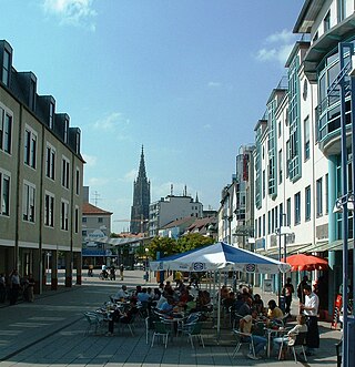
Neu-Ulm is the seat of the Neu-Ulm district and a town in Swabia, Bavaria. Neighbouring towns include Ulm, Senden, Pfaffenhofen an der Roth, Holzheim, Nersingen and Elchingen. The population is 58,978.

<span class="mw-page-title-main">Elchingen</span> Settlement in Germany

Elchingen is a municipality about 7 km east of Ulm–Neu-Ulm in the district of Neu-Ulm in Bavaria, Germany.

<span class="mw-page-title-main">Weißenhorn</span> Town in Bavaria, Germany

Weißenhorn is a town in the district of Neu-Ulm in Bavaria. Weißenhorn is located about 22 km southeast of Ulm.

<span class="mw-page-title-main">Mindelheim</span> Town in Bavaria, Germany

Mindelheim is a town in Swabia, Bavaria, Germany. The town is the capital of the Unterallgäu district. At various points in history it was the chief settlement of an eponymous state.

<span class="mw-page-title-main">Pfaffenhofen an der Roth</span> Municipality in Bavaria, Germany

Pfaffenhofen an der Roth is a municipality in the district of Neu-Ulm in Bavaria in Germany. Its most famous son is Hermann Köhl, an aviation pioneer of the 1920s.

<span class="mw-page-title-main">Vöhringen, Bavaria</span> Town in Bavaria, Germany

Vöhringen is a town in the district of Neu-Ulm in Bavaria, Germany. It is located on the Iller, approximately 18 km south of Ulm and 40 km north of Memmingen. It is in the Donau-Iller Region in Central Swabia.

<span class="mw-page-title-main">Eckental</span> Municipality in Bavaria, Germany

Eckental is a municipality in the district of Erlangen-Höchstadt, in Bavaria, Germany. It is situated 14 km east of Erlangen, and 16 km northeast of Nuremberg. It contains 17 districts: Benzendorf, Brand, Brandermühle, Büg, Ebach, Eckenhaid, Eckenmühle, Eschenau, Forth, Frohnhof, Herpersdorf, Illhof, Marquardsburg, Mausgesees, Oberschöllenbach, Oedhof, and Unterschöllenbach.

<span class="mw-page-title-main">Krumbach, Bavaria</span> Municipality in Bavaria, Germany

Krumbach is a town with 13,000 residents in the district Günzburg in Swabia, Bavaria, Germany. It is the second biggest town in the district.

<span class="mw-page-title-main">Ichenhausen</span> Town in Bavaria, Germany

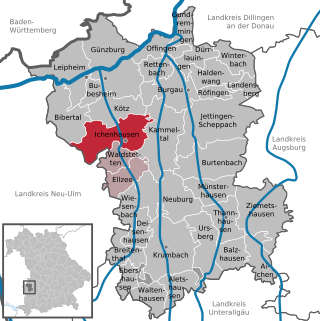
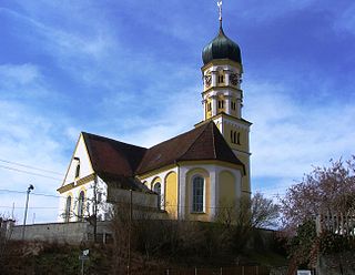
Ichenhausen is a town in the district of Günzburg, in Bavaria, Germany. It is situated on the river Günz, 9 km south of Günzburg.

<span class="mw-page-title-main">Leipheim</span> Town in Bavaria, Germany

Leipheim is a town in the district of Günzburg, in Bavaria, Germany. It is situated on the Danube, 5 kilometres west of Günzburg, and 17 kilometres northeast of Ulm. The village Riedheim and the hamlet Weissingen are districts of Leipheim. Since 1993, Leipheim has been twinned with the Hungarian town Fonyód.

<span class="mw-page-title-main">Roggenburg, Bavaria</span> Municipality in Bavaria, Germany

Roggenburg is a municipality in the district of Neu-Ulm in Bavaria in Germany.

<span class="mw-page-title-main">Heroldsberg</span> Municipality in Bavaria, Germany

Heroldsberg is a municipality in the district of Erlangen-Höchstadt, in Bavaria, Germany. It is located eleven kilometers north-east from the city of Nuremberg and 23 kilometers east from Erlangen and is the headquarters of Schwan-Stabilo.

<span class="mw-page-title-main">Altenstadt, Swabia</span> Municipality in Bavaria, Germany

Altenstadt is a municipality in the district of Neu-Ulm in Bavaria in Germany.

<span class="mw-page-title-main">Kellmünz</span> Municipality in Bavaria, Germany

Kellmünz(official: Kellmünz a.d.Iller) is a municipality in the district of Neu-Ulm in Bavaria in Germany.

<span class="mw-page-title-main">Bad Grönenbach</span> Municipality in Bavaria, Germany

Bad Grönenbach is a market town in the district of Unterallgäu in Bavaria, Germany. It belongs to the region of Upper Swabia and the headquarters of the Gemeindeverband of the same name.

<span class="mw-page-title-main">Kirchheim in Schwaben</span> Municipality in Bavaria, Germany

Kirchheim or Kirchheim in Schwaben is a municipality and a market town in the district of Unterallgäu in the region of Swabia (Schwaben) in the south-west of Bavaria, Germany. The town was greatly influenced by the Fugger family. North-east of the town lies the Augsburg Western Woods Nature Park.

<span class="mw-page-title-main">Untergriesbach</span> Municipality in Bavaria, Germany

Untergriesbach is a municipality in the district of Passau in Bavaria in Germany.

References