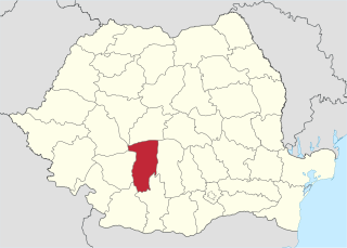
Vâlcea County is a county (județ) that lies in south-central Romania. Located in the historical regions of Oltenia and Muntenia, it is also part of the wider Wallachia region. Its capital city is Râmnicu Vâlcea.
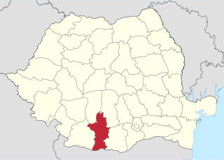
Olt County is a county (județ) of Romania on the border with Bulgaria, in the historical regions of Oltenia and Muntenia. The capital city is Slatina.

Sibiu County is a county of Romania, in the historical region of Transylvania. Its county seat is the namesake town of Sibiu.

The Mureș or Maros is a 789-kilometre-long (490 mi) river in Eastern Europe. Its drainage basin covers an area of 30,332 km2 (11,711 sq mi). It originates in the Hășmașu Mare Range in the Eastern Carpathian Mountains, Romania, rising close to the headwaters of the river Olt, and joins the Tisza at Szeged in southeastern Hungary. In Romania, its length is 761 km (473 mi) and its basin size is 27,890 km2 (10,770 sq mi).

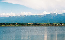
The Făgăraș Mountains are the highest mountains of the Southern Carpathians, in Romania.

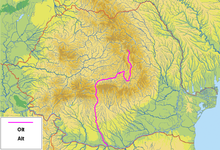
DN7 is a national road in Romania which links Bucharest with the Banat region, in western Romania, and further to the eastern European capitals Budapest and Belgrade via the border with Hungary at Nădlac. It is a high-traffic road and the preferred route for trucks. Near Râmnicu Vâlcea, the road crosses the Southern Carpathians along the Olt River, through the Valea Oltului touristic region.
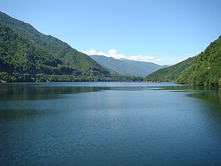
The Lotru is a right tributary of the river Olt in Romania. Its source is in the Parâng Mountains. It feeds the reservoirs Vidra, Malaia and Brădișor. It flows into the Olt in Golotreni, near the town of Brezoi. It passes through the communes Voineasa, Malaia, and Brezoi. Its length is 83 km (52 mi) and its basin size is 990 km2 (380 sq mi).
The Avrig is a left tributary of the river Olt in Romania. It discharges into the Olt in the town Avrig. The upper reach of the river is also known as the Râul Mare. Its source is the Avrig Lake in the Făgăraș Mountains. Its length is 24 km (15 mi) and its basin size is 66 km2 (25 sq mi).

The Râul Negru is a left tributary of the river Olt in Romania. It joins the Olt in Lunca Câlnicului. The Râul Negru flows through the villages Lemnia, Lunga, Catalina, Hătuica, Surcea, Telechia, Bita, Reci, Sântionlunca, Ozun, Băcel, Chichiș and Lunca Câlnicului. Its length is 88 km (55 mi) and its basin size is 2,349 km2 (907 sq mi).

The Topolog is a left tributary of the river Olt in Romania. It discharges into the Olt in Ostroveni. It is formed by two source rivers that come from the southern slopes of the Făgăraș Mountains: Negoiu and Scara. It flows through the communes Sălătrucu, Șuici, Cepari, Tigveni, Ciofrângeni, Poienarii de Argeș, Milcoiu, Nicolae Bălcescu and Galicea. Including its longest source river, Negoiu, its total length is 111.5 km (69.3 mi) and its basin size is 546.3 km2 (210.9 sq mi). For much of its length it forms the border between the counties Argeș and Vâlcea.
Cuca is a commune in Argeș County, Muntenia, Romania. It is composed of fourteen villages: Bălțata, Bărbălani, Cârcești, Cotu, Crivățu, Cuca, Lăunele de Sus, Măcăi, Mănești, Sinești, Stănicei, Teodorești, Valea Cucii and Vonigeasa. It was one of the most remote places in Romania. Today, in Romanian, Cuca Măcăii means "a remote village or place, very difficult to reach".

Băbeni is a town located in Vâlcea County, Romania. The town, elevated to that status in 2002, administers six villages: Bonciu, Capu Dealului, Pădurețu, Români, Tătărani, and Valea Mare. It is situated in the historical region of Oltenia.
This article discusses the administrative divisions of the Kingdom of Romania between 1941 and 1944. As a result of the Soviet occupation of Bessarabia and Northern Bukovina, Second Vienna Award and the Treaty of Craiova, territories that had previously been part of Romania were lost to the Soviet Union, Hungary and Bulgaria respectively. By September 1940 the administrative system set up in 1938 based on 'ținuturi' (regions) was disbanded and the former counties (județe) were reintroduced.

Praetorium II (Racovița) was a fort in the Roman province of Dacia near the present village of Racovița, Vâlcea. It was built in the middle of the 3rd century, part of the Roman frontier system of the Limes Alutanus along the Olt (river) and was the largest fort in the mountain area of the Limes.

Praetorium I (Copăceni) was a fort in the Roman province of Dacia near the present village of Copăceni, Racovița, Vâlcea, Romania. It was part of the Roman frontier system of the Limes Alutanus along the Olt (river). It was built in 138 and reinforced with two towers two years later.
